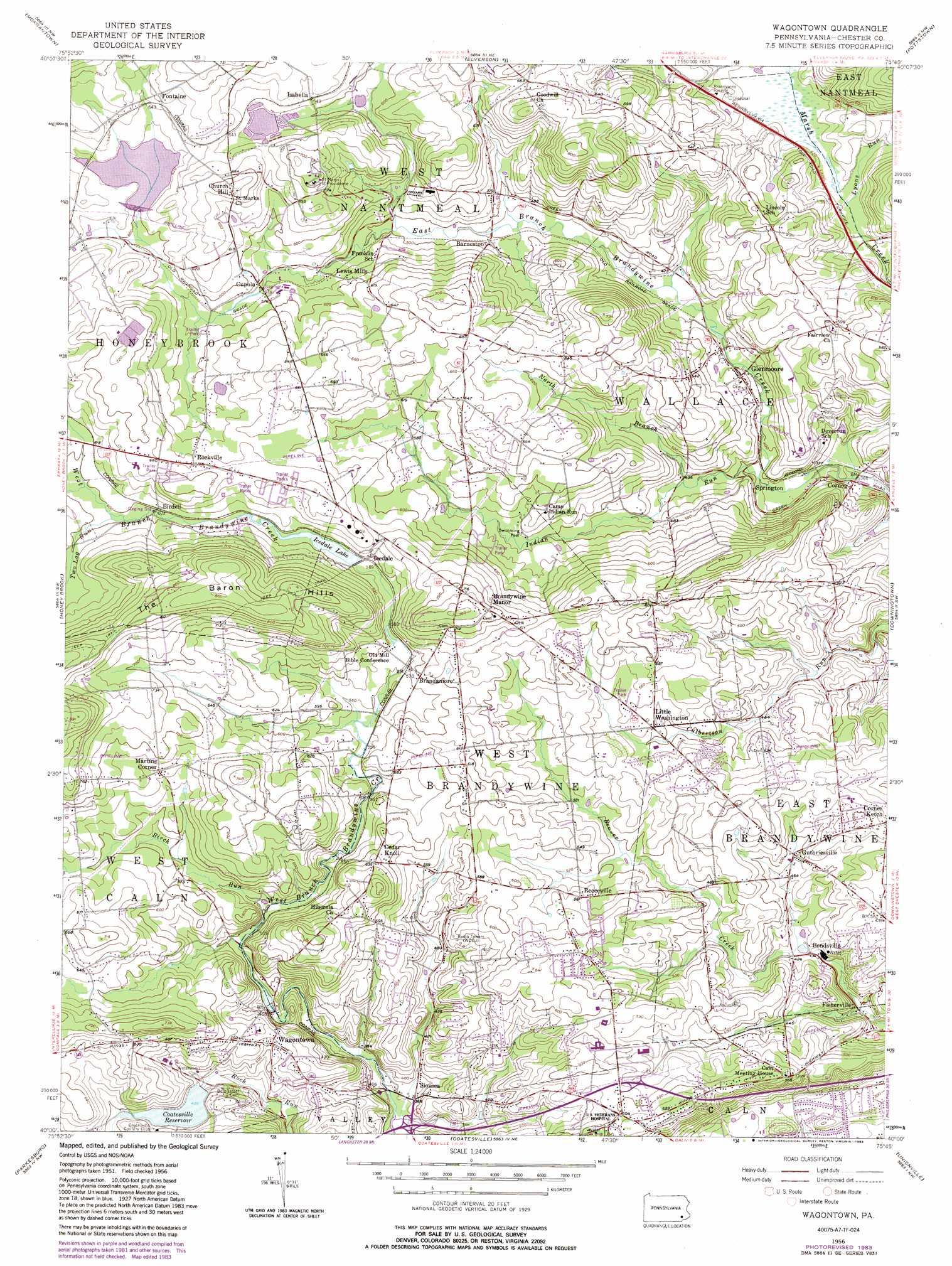
Wagontown Topo Map Pennsylvania
To zoom in, hover over the map of Wagontown
USGS Topo Quad 40075a7 - 1:24,000 scale
| Topo Map Name: | Wagontown |
| USGS Topo Quad ID: | 40075a7 |
| Print Size: | ca. 21 1/4" wide x 27" high |
| Southeast Coordinates: | 40° N latitude / 75.75° W longitude |
| Map Center Coordinates: | 40.0625° N latitude / 75.8125° W longitude |
| U.S. State: | PA |
| Filename: | o40075a7.jpg |
| Download Map JPG Image: | Wagontown topo map 1:24,000 scale |
| Map Type: | Topographic |
| Topo Series: | 7.5´ |
| Map Scale: | 1:24,000 |
| Source of Map Images: | United States Geological Survey (USGS) |
| Alternate Map Versions: |
Wagontown PA 1956, updated 1957 Download PDF Buy paper map Wagontown PA 1956, updated 1966 Download PDF Buy paper map Wagontown PA 1956, updated 1970 Download PDF Buy paper map Wagontown PA 1956, updated 1970 Download PDF Buy paper map Wagontown PA 1956, updated 1976 Download PDF Buy paper map Wagontown PA 1956, updated 1977 Download PDF Buy paper map Wagontown PA 1956, updated 1983 Download PDF Buy paper map Wagontown PA 1956, updated 1983 Download PDF Buy paper map Wagontown PA 1999, updated 2001 Download PDF Buy paper map Wagontown PA 2010 Download PDF Buy paper map Wagontown PA 2013 Download PDF Buy paper map Wagontown PA 2016 Download PDF Buy paper map |
1:24,000 Topo Quads surrounding Wagontown
Sinking Spring |
Reading |
Birdsboro |
Boyertown |
Sassamansville |
Terre Hill |
Morgantown |
Elverson |
Pottstown |
Phoenixville |
New Holland |
Honey Brook |
Wagontown |
Downingtown |
Malvern |
Gap |
Parkesburg |
Coatesville |
Unionville |
West Chester |
Kirkwood |
Oxford |
West Grove |
Kennett Square |
Wilmington North |
> Back to 40075a1 at 1:100,000 scale
> Back to 40074a1 at 1:250,000 scale
> Back to U.S. Topo Maps home
Wagontown topo map: Gazetteer
Wagontown: Airports
Beiler Airport elevation 212m 695′Wagontown: Crossings
Pennsylvania Turnpike Interchange 14 elevation 184m 603′Wagontown: Dams
Bondsville Dam elevation 128m 419′Brandamore Dam elevation 178m 583′
Coatesville Dam elevation 157m 515′
Robert G Struble Dam elevation 187m 613′
Rock Run Dam elevation 148m 485′
Wagontown Dam elevation 134m 439′
Wagontown: Populated Places
Barneston elevation 147m 482′Birdell elevation 184m 603′
Bondsville elevation 126m 413′
Brandamore elevation 189m 620′
Brandywine Manor elevation 215m 705′
Caln Meeting House elevation 172m 564′
Cedar Knoll elevation 192m 629′
Church Hill elevation 221m 725′
Cornog elevation 110m 360′
Cupola elevation 171m 561′
Dampman elevation 189m 620′
Fisherville elevation 106m 347′
Fontaine elevation 206m 675′
Glenmoore elevation 136m 446′
Guthriesville elevation 147m 482′
Icedale elevation 178m 583′
Isabella elevation 196m 643′
Lewis Mills elevation 188m 616′
Little Washington elevation 159m 521′
Martins Corner elevation 200m 656′
Reeceville elevation 169m 554′
Rocklyn elevation 207m 679′
Rockville elevation 207m 679′
Siousca elevation 114m 374′
Springton elevation 122m 400′
Wagontown elevation 163m 534′
Wyebrooke elevation 189m 620′
Wagontown: Post Offices
Barnestown Post Office (historical) elevation 147m 482′Brandamore Post Office elevation 185m 606′
Glenmoore Post Office elevation 144m 472′
Isabella Post Office (historical) elevation 196m 643′
Wagontown Post Office elevation 161m 528′
Wagontown: Reservoirs
Coatesville Reservoir elevation 143m 469′Icedale Lake elevation 177m 580′
Robert G Struble Lake elevation 187m 613′
Struble Lake elevation 187m 613′
Wagontown: Streams
Birch Run elevation 151m 495′Indian Run elevation 122m 400′
Lyons Run elevation 155m 508′
North Branch Indian Run elevation 131m 429′
Two Log Run elevation 182m 597′
Wagontown digital topo map on disk
Buy this Wagontown topo map showing relief, roads, GPS coordinates and other geographical features, as a high-resolution digital map file on DVD:
Atlantic Coast (NY, NJ, PA, DE, MD, VA, NC)
Buy digital topo maps: Atlantic Coast (NY, NJ, PA, DE, MD, VA, NC)
 map DVD")