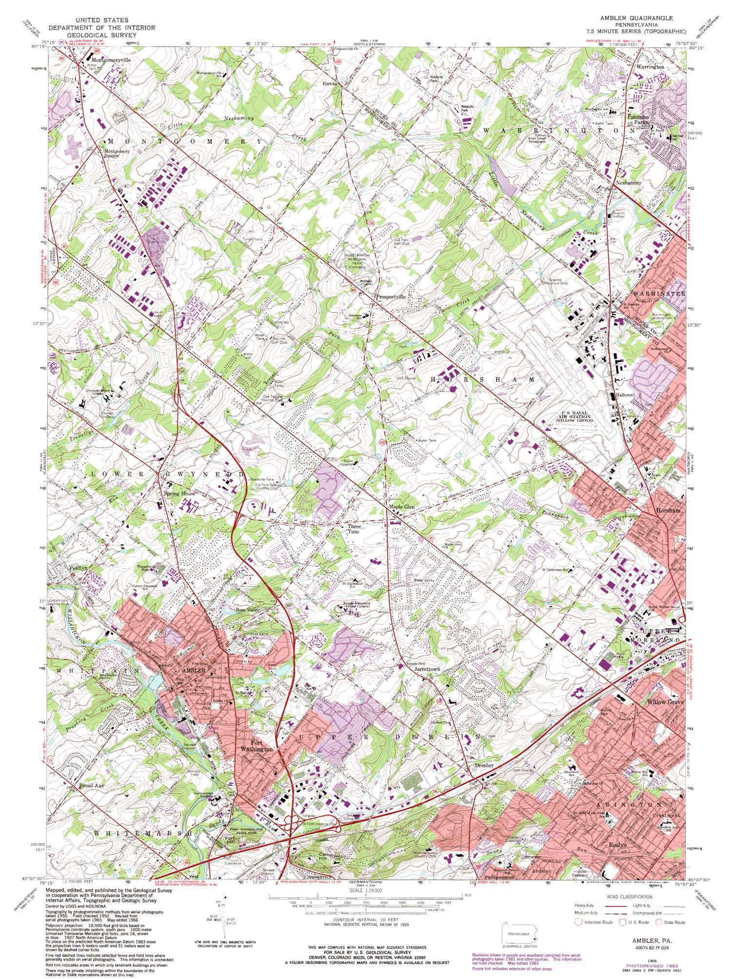
Ambler Topo Map Pennsylvania
To zoom in, hover over the map of Ambler
USGS Topo Quad 40075b2 - 1:24,000 scale
| Topo Map Name: | Ambler |
| USGS Topo Quad ID: | 40075b2 |
| Print Size: | ca. 21 1/4" wide x 27" high |
| Southeast Coordinates: | 40.125° N latitude / 75.125° W longitude |
| Map Center Coordinates: | 40.1875° N latitude / 75.1875° W longitude |
| U.S. State: | PA |
| Filename: | o40075b2.jpg |
| Download Map JPG Image: | Ambler topo map 1:24,000 scale |
| Map Type: | Topographic |
| Topo Series: | 7.5´ |
| Map Scale: | 1:24,000 |
| Source of Map Images: | United States Geological Survey (USGS) |
| Alternate Map Versions: |
Ambler PA 1952, updated 1953 Download PDF Buy paper map Ambler PA 1952, updated 1960 Download PDF Buy paper map Ambler PA 1966, updated 1968 Download PDF Buy paper map Ambler PA 1966, updated 1974 Download PDF Buy paper map Ambler PA 1966, updated 1983 Download PDF Buy paper map Ambler PA 1966, updated 1983 Download PDF Buy paper map Ambler PA 1999, updated 2001 Download PDF Buy paper map Ambler PA 2010 Download PDF Buy paper map Ambler PA 2013 Download PDF Buy paper map Ambler PA 2016 Download PDF Buy paper map |
1:24,000 Topo Quads surrounding Ambler
Milford Square |
Quakertown |
Bedminster |
Lumberville |
Stockton |
Perkiomenville |
Telford |
Doylestown |
Buckingham |
Lambertville |
Collegeville |
Lansdale |
Ambler |
Hatboro |
Langhorne |
Valley Forge |
Norristown |
Germantown |
Frankford |
Beverly |
Media |
Lansdowne |
Philadelphia |
Camden |
Moorestown |
> Back to 40075a1 at 1:100,000 scale
> Back to 40074a1 at 1:250,000 scale
> Back to U.S. Topo Maps home
Ambler topo map: Gazetteer
Ambler: Airports
Asplundh Airport elevation 84m 275′Copter-Barness Airport elevation 97m 318′
Horsham Township Police Airport elevation 79m 259′
Horsham Valley Golf Course Airport elevation 101m 331′
Kenas Airport elevation 105m 344′
Keystone Helicopter Corp/Toll Brothers Airport elevation 103m 337′
Melville Airport elevation 101m 331′
Montgomeryville Airport elevation 140m 459′
Prudential Business Campus Airport elevation 78m 255′
Rorer Group Airport elevation 70m 229′
Turner Field (historical) elevation 107m 351′
Whisper Pines Airport elevation 110m 360′
Ambler: Crossings
Interchange 339 elevation 57m 187′Interchange 340 elevation 64m 209′
Pennsylvania Turnpike Interchange 16 elevation 70m 229′
Pennsylvania Turnpike Interchange 26 elevation 50m 164′
Ambler: Dams
Cornog Dam elevation 70m 229′Craft Dam elevation 76m 249′
Dager Dam elevation 79m 259′
Foedisch Dam elevation 80m 262′
Hoopes Dam elevation 76m 249′
Keasby Mattison Dam elevation 58m 190′
Lock Alsh Dam elevation 86m 282′
Lock Alsh Reservoir Dam elevation 84m 275′
Lock Linden Dam elevation 79m 259′
Long Dam elevation 72m 236′
McKean Dam elevation 79m 259′
Mehler Dam elevation 80m 262′
Neshaminy SCS Dam 611 elevation 68m 223′
Rittenhouse Dam elevation 46m 150′
Taylor Dam elevation 84m 275′
Thompson Dam elevation 55m 180′
Warrington Township Retention Basin Dam elevation 71m 232′
Worthington Dam elevation 75m 246′
Wright Dam elevation 107m 351′
Ambler: Parks
Ambler City Park elevation 64m 209′Bradford Reservoir Recreation Area elevation 78m 255′
Burn Brae Park elevation 87m 285′
Carl Kohler Park elevation 75m 246′
Cedar Hill Road Park elevation 105m 344′
Cheston Robbins Park elevation 96m 314′
Cheston-Robbins Park elevation 102m 334′
Crestmont Park elevation 103m 337′
Deep Meadow Park elevation 82m 269′
Evergreen Manor Park elevation 92m 301′
Fort Washington State Park elevation 68m 223′
Genuardi Pool and Pavillion elevation 93m 305′
Graeme Park elevation 67m 219′
Graeme State Park elevation 76m 249′
Henry Lee Willett Park elevation 82m 269′
Hideaway Hills Park elevation 94m 308′
Horsham Township Park elevation 95m 311′
Horsham Valley Township Park elevation 76m 249′
Jarrett Road Park elevation 104m 341′
Lair Park elevation 71m 232′
Loch Alsh Park elevation 87m 285′
Lower Gwynedd Park elevation 73m 239′
Lower Gwynedd Township Centennial Park elevation 91m 298′
Lower Nike Park elevation 83m 272′
Meetinghouse Park elevation 88m 288′
Meetinghouse Park elevation 88m 288′
Mondock Commons Park elevation 84m 275′
Mundock Park elevation 54m 177′
Samuel Carpenter Park elevation 72m 236′
Strawbridge Park elevation 81m 265′
Tannerie Run Park elevation 101m 331′
The Highlands Park elevation 71m 232′
Three Tuns Park elevation 111m 364′
Twin Oaks Park elevation 101m 331′
Upper Nike Park elevation 98m 321′
Willett Park elevation 85m 278′
Windlestrae Park elevation 97m 318′
Ambler: Populated Places
Ambler elevation 65m 213′Ambler House elevation 77m 252′
Arbor Glen elevation 114m 374′
Broad Axe elevation 87m 285′
Broad Axe Village elevation 82m 269′
Carpenters Way elevation 112m 367′
Cloverly Farms elevation 106m 347′
Crestmont elevation 106m 347′
Dawesfield elevation 97m 318′
De La Salle elevation 146m 479′
Dresher elevation 62m 203′
Dresher Woods elevation 63m 206′
Dreshertowne elevation 94m 308′
Dublin Chase elevation 59m 193′
Dublin Crossing elevation 98m 321′
Dublin Estates elevation 84m 275′
Dublin Glen elevation 114m 374′
Dublin Hunt II elevation 81m 265′
Dublin Lea elevation 107m 351′
Dublin Meadows elevation 114m 374′
Estate of Dublin elevation 101m 331′
Estates at Cedar Hill elevation 111m 364′
Estates of Horsham Lea elevation 116m 380′
Estates of Montgomery elevation 109m 357′
Eureka elevation 94m 308′
Fairoaks elevation 74m 242′
Fort Washington elevation 71m 232′
Georgetown of Philadelphia elevation 91m 298′
Greystone Manor elevation 68m 223′
Gwynedd Estates elevation 108m 354′
Gwynedd Knoll elevation 134m 439′
Gwynedd Lea elevation 127m 416′
Gwynmont Farms elevation 147m 482′
Gwynn Oaks elevation 104m 341′
Hallowell elevation 103m 337′
Hampton Green elevation 135m 442′
Horsham elevation 76m 249′
Horsham Chase elevation 105m 344′
Horsham Terrace elevation 94m 308′
Jarrettown elevation 77m 252′
Maple Glen elevation 114m 374′
Maple Glen Hollow elevation 105m 344′
Meadow View Estates elevation 110m 360′
Meadowcreek Estates elevation 84m 275′
Meadows at Lower Gwynedd elevation 72m 236′
Meetinghouse Village elevation 101m 331′
Mercer Hill Village elevation 70m 229′
Montgomery Crossing elevation 119m 390′
Montgomery Greeny elevation 103m 337′
Montgomery Oaks elevation 116m 380′
Montgomeryville elevation 139m 456′
Mount Pleasant elevation 69m 226′
Myers Tract elevation 94m 308′
Neshaminy elevation 76m 249′
Palomino Farms elevation 83m 272′
Parsons Glen elevation 107m 351′
Pen Ambler elevation 72m 236′
Penllyn elevation 71m 232′
Pennbrooke Manor elevation 89m 291′
Pheasant Knoll elevation 86m 282′
Prospectville elevation 107m 351′
Rose Valley elevation 93m 305′
Roslyn elevation 73m 239′
Saw Mill Valley elevation 101m 331′
Spring House elevation 87m 285′
Squires Estates elevation 113m 370′
Squires Knoll elevation 100m 328′
Stuart Creek Farms elevation 68m 223′
Talamore elevation 91m 298′
Talamore at Oak Terrace elevation 85m 278′
Tannerie Woods elevation 104m 341′
The Meadows elevation 101m 331′
The Meadows of Horsham Towne elevation 103m 337′
The Reserve at Trewellyn elevation 101m 331′
The Ridings of Montgomery elevation 109m 357′
The Woodlands elevation 107m 351′
The Woods elevation 99m 324′
Three Tuns elevation 114m 374′
Trewellyn Estates elevation 98m 321′
Upper Dublin elevation 84m 275′
Victoria Glen elevation 105m 344′
Warrington elevation 120m 393′
Welsh Woods elevation 114m 374′
Willow Manor elevation 101m 331′
Willow Manor Farms elevation 84m 275′
Willowmere elevation 73m 239′
Winding Estates elevation 94m 308′
Windsor Pass elevation 91m 298′
Wister Woods elevation 77m 252′
Wooded Pond elevation 93m 305′
Wynmere Downs elevation 97m 318′
Ambler: Post Offices
Ambler Post Office elevation 57m 187′Dresher Post Office elevation 60m 196′
Horsham Post Office elevation 81m 265′
Maple Glen Branch Post Office elevation 116m 380′
Springhouse Branch Post Office elevation 95m 311′
Ambler: Reservoirs
Bradford Reservoir elevation 73m 239′Lock Alsh Reservoir elevation 84m 275′
Warrington Lake elevation 68m 223′
Ambler: Streams
Park Creek elevation 65m 213′Pine Run elevation 81m 265′
Prophecy Creek elevation 51m 167′
Sandy Run elevation 45m 147′
Willow Run elevation 66m 216′
Ambler: Summits
Camp Hill elevation 104m 341′Fort Hill elevation 88m 288′
Ambler digital topo map on disk
Buy this Ambler topo map showing relief, roads, GPS coordinates and other geographical features, as a high-resolution digital map file on DVD:
Atlantic Coast (NY, NJ, PA, DE, MD, VA, NC)
Buy digital topo maps: Atlantic Coast (NY, NJ, PA, DE, MD, VA, NC)
 map DVD")