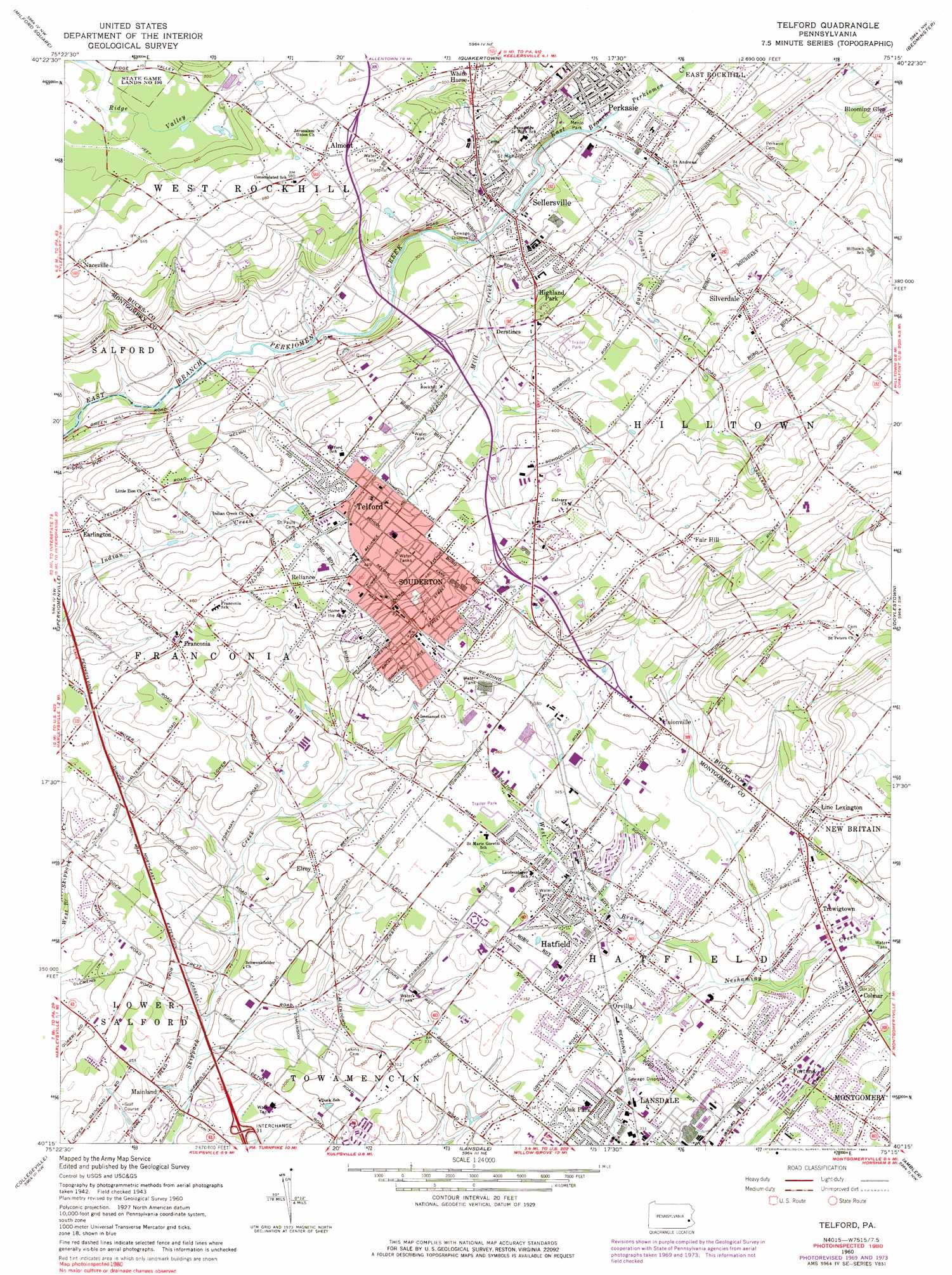
Telford Topo Map Pennsylvania
To zoom in, hover over the map of Telford
USGS Topo Quad 40075c3 - 1:24,000 scale
| Topo Map Name: | Telford |
| USGS Topo Quad ID: | 40075c3 |
| Print Size: | ca. 21 1/4" wide x 27" high |
| Southeast Coordinates: | 40.25° N latitude / 75.25° W longitude |
| Map Center Coordinates: | 40.3125° N latitude / 75.3125° W longitude |
| U.S. State: | PA |
| Filename: | o40075c3.jpg |
| Download Map JPG Image: | Telford topo map 1:24,000 scale |
| Map Type: | Topographic |
| Topo Series: | 7.5´ |
| Map Scale: | 1:24,000 |
| Source of Map Images: | United States Geological Survey (USGS) |
| Alternate Map Versions: |
Telford PA 1953, updated 1954 Download PDF Buy paper map Telford PA 1960, updated 1963 Download PDF Buy paper map Telford PA 1960, updated 1967 Download PDF Buy paper map Telford PA 1960, updated 1971 Download PDF Buy paper map Telford PA 1960, updated 1975 Download PDF Buy paper map Telford PA 1960, updated 1983 Download PDF Buy paper map Telford PA 1995, updated 1996 Download PDF Buy paper map Telford PA 1997, updated 2000 Download PDF Buy paper map Telford PA 2010 Download PDF Buy paper map Telford PA 2013 Download PDF Buy paper map Telford PA 2016 Download PDF Buy paper map |
1:24,000 Topo Quads surrounding Telford
Allentown West |
Allentown East |
Hellertown |
Riegelsville |
Frenchtown |
East Greenville |
Milford Square |
Quakertown |
Bedminster |
Lumberville |
Sassamansville |
Perkiomenville |
Telford |
Doylestown |
Buckingham |
Phoenixville |
Collegeville |
Lansdale |
Ambler |
Hatboro |
Malvern |
Valley Forge |
Norristown |
Germantown |
Frankford |
> Back to 40075a1 at 1:100,000 scale
> Back to 40074a1 at 1:250,000 scale
> Back to U.S. Topo Maps home
Telford topo map: Gazetteer
Telford: Airports
Boland Airport elevation 118m 387′Gehris Airport elevation 185m 606′
I G Rosenberger Inc Airport elevation 132m 433′
Navarro Field elevation 159m 521′
Souderton Airport elevation 149m 488′
Telford: Bridges
South Perkasie Covered Bridge elevation 95m 311′Telford: Crossings
Pennsylvania Turnpike Interchange 31 elevation 83m 272′Telford: Dams
Bergey Dam elevation 104m 341′Fehl Dam elevation 114m 374′
Gerhart Dam elevation 82m 269′
Hallman Dam elevation 80m 262′
Hilltown Dam elevation 112m 367′
Landis Dam elevation 89m 291′
Moyer Dam elevation 115m 377′
Telford: Parks
Earl B Druckenmiller Park elevation 93m 305′Enos Godshall Park elevation 94m 308′
Franconia Community Park elevation 121m 396′
Hatfield Community Park elevation 99m 324′
Holiday House Recreation Area elevation 160m 524′
James Memorial Park elevation 171m 561′
John S Clemens Memorial Park elevation 97m 318′
Kulp Park elevation 94m 308′
Lenare Park elevation 91m 298′
Menlo Park elevation 102m 334′
Souderton Borough Park elevation 145m 475′
Souderton Community Park elevation 109m 357′
State Game Lands Number 196 elevation 145m 475′
Telford Park elevation 124m 406′
Telford: Populated Places
Almont elevation 174m 570′Apple Tree Estates elevation 94m 308′
Banbury elevation 102m 334′
Banbury Crossing elevation 107m 351′
Belcourt Manor elevation 99m 324′
Bramble Gate elevation 97m 318′
Bremen Woods elevation 78m 255′
Bridgetown elevation 106m 347′
Bridle Run elevation 140m 459′
Cambridge Reserve elevation 114m 374′
Cobblestone East elevation 116m 380′
Colmar elevation 96m 314′
Cowpath Village elevation 93m 305′
Cross Gate elevation 114m 374′
Derstine Estates elevation 113m 370′
Derstines elevation 108m 354′
Dock Manor Terrace elevation 86m 282′
Earlington elevation 115m 377′
Elroy elevation 101m 331′
Estates at Tall Oaks elevation 129m 423′
Fair Hill elevation 191m 626′
Forrest View elevation 108m 354′
Fortuna elevation 106m 347′
Franconia elevation 121m 396′
Franconia Hunt elevation 131m 429′
Gristmill Run elevation 92m 301′
Hatfield elevation 101m 331′
Hidden Springs Mobile Home Park elevation 153m 501′
Highland Park elevation 119m 390′
Hillcrest Estate elevation 90m 295′
Hilpert elevation 102m 334′
Hunter Crest elevation 92m 301′
Hunters Greene elevation 133m 436′
Kimberwick Green elevation 117m 383′
Lexington Farms elevation 102m 334′
Lexington Leas elevation 92m 301′
Line Lexington elevation 118m 387′
Lions Gate II elevation 111m 364′
Mainland elevation 70m 229′
Mews at Wickford Commons elevation 104m 341′
Naceville elevation 168m 551′
Oak Grove Trailer Park elevation 109m 357′
Oak Wood East elevation 103m 337′
Orchard Glen elevation 122m 400′
Orvilla elevation 101m 331′
Pear Tree Village elevation 127m 416′
Pelham Green elevation 88m 288′
Pennfield Manor elevation 116m 380′
Perkasie elevation 110m 360′
Reliance elevation 143m 469′
Schlichter elevation 171m 561′
Sellersville elevation 104m 341′
Sellersville Heights elevation 98m 321′
Selsie Village elevation 115m 377′
Silverdale elevation 132m 433′
Society Meadows elevation 128m 419′
Souderton elevation 128m 419′
Stonycrest elevation 119m 390′
Summerwind elevation 91m 298′
Telford elevation 135m 442′
Telford Chase elevation 147m 482′
Telford Commons elevation 126m 413′
Telford Hills elevation 114m 374′
Trewigtown elevation 97m 318′
Unionville elevation 122m 400′
Village at Salford Mill elevation 94m 308′
Village Scene Trailer Park elevation 109m 357′
White Horse elevation 166m 544′
Wynmere Hunt elevation 100m 328′
Yorkshire Commons elevation 106m 347′
Telford: Post Offices
Almont Post Office (historical) elevation 174m 570′Colmar Post Office elevation 97m 318′
Earlington Post Office elevation 115m 377′
Line Lexington Post Office elevation 104m 341′
Mainland Post Office elevation 73m 239′
Sellersville Post Office elevation 100m 328′
Sellersville Post Office (historical) elevation 104m 341′
Silverdale Post Office (historical) elevation 132m 433′
Souderton Post Office elevation 133m 436′
Telford: Reservoirs
Lenape Lake elevation 91m 298′Telford: Streams
Mill Creek elevation 89m 291′Pleasant Spring Creek elevation 94m 308′
Telford digital topo map on disk
Buy this Telford topo map showing relief, roads, GPS coordinates and other geographical features, as a high-resolution digital map file on DVD:
Atlantic Coast (NY, NJ, PA, DE, MD, VA, NC)
Buy digital topo maps: Atlantic Coast (NY, NJ, PA, DE, MD, VA, NC)
 map DVD")