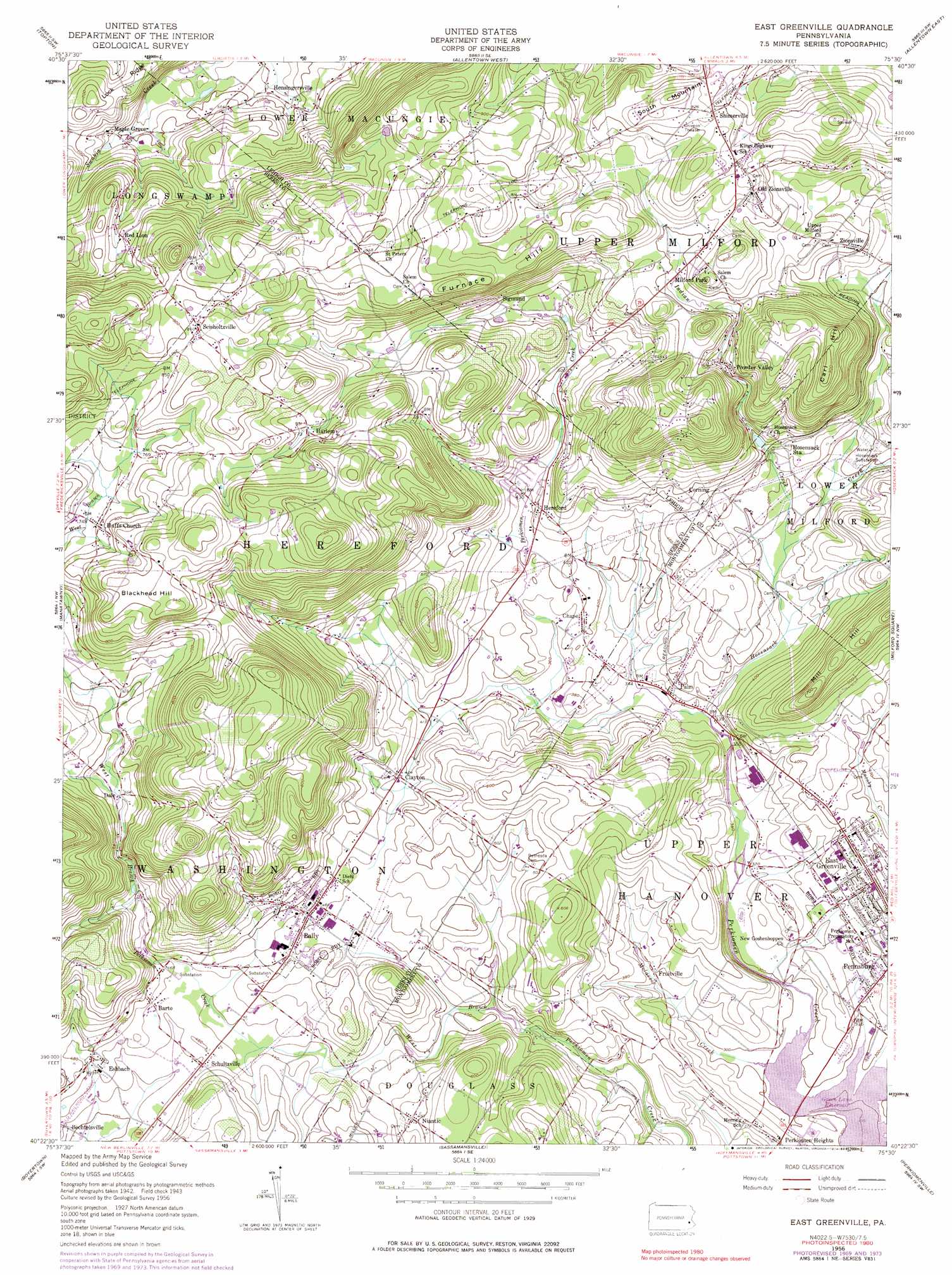
East Greenville Topo Map Pennsylvania
To zoom in, hover over the map of East Greenville
USGS Topo Quad 40075d5 - 1:24,000 scale
| Topo Map Name: | East Greenville |
| USGS Topo Quad ID: | 40075d5 |
| Print Size: | ca. 21 1/4" wide x 27" high |
| Southeast Coordinates: | 40.375° N latitude / 75.5° W longitude |
| Map Center Coordinates: | 40.4375° N latitude / 75.5625° W longitude |
| U.S. State: | PA |
| Filename: | o40075d5.jpg |
| Download Map JPG Image: | East Greenville topo map 1:24,000 scale |
| Map Type: | Topographic |
| Topo Series: | 7.5´ |
| Map Scale: | 1:24,000 |
| Source of Map Images: | United States Geological Survey (USGS) |
| Alternate Map Versions: |
East Greenville PA 1956, updated 1956 Download PDF Buy paper map East Greenville PA 1956, updated 1958 Download PDF Buy paper map East Greenville PA 1956, updated 1966 Download PDF Buy paper map East Greenville PA 1956, updated 1971 Download PDF Buy paper map East Greenville PA 1956, updated 1974 Download PDF Buy paper map East Greenville PA 1956, updated 1983 Download PDF Buy paper map East Greenville PA 1992, updated 1995 Download PDF Buy paper map East Greenville PA 1999, updated 2002 Download PDF Buy paper map East Greenville PA 2010 Download PDF Buy paper map East Greenville PA 2013 Download PDF Buy paper map East Greenville PA 2016 Download PDF Buy paper map |
1:24,000 Topo Quads surrounding East Greenville
New Tripoli |
Slatedale |
Cementon |
Catasauqua |
Nazareth |
Kutztown |
Topton |
Allentown West |
Allentown East |
Hellertown |
Fleetwood |
Manatawny |
East Greenville |
Milford Square |
Quakertown |
Birdsboro |
Boyertown |
Sassamansville |
Perkiomenville |
Telford |
Elverson |
Pottstown |
Phoenixville |
Collegeville |
Lansdale |
> Back to 40075a1 at 1:100,000 scale
> Back to 40074a1 at 1:250,000 scale
> Back to U.S. Topo Maps home
East Greenville topo map: Gazetteer
East Greenville: Airports
Butter Valley Golf Port Airport elevation 138m 452′East Greenville: Bridges
Barto Bridge elevation 151m 495′East Greenville: Dams
Hensingersville Dam elevation 257m 843′Hosensack Number Four Dam elevation 149m 488′
Kurtzs Dam elevation 95m 311′
Mill Dam elevation 112m 367′
Mill Side Park Dam elevation 100m 328′
East Greenville: Parks
Barto Community Park elevation 139m 456′Green Lane Reservoir Park elevation 89m 291′
Hereford Township Park elevation 269m 882′
Melcher Park elevation 145m 475′
Washington Township Park elevation 139m 456′
East Greenville: Populated Places
Bally elevation 147m 482′Barto elevation 139m 456′
Chapel elevation 123m 403′
Churchville elevation 142m 465′
Clayton elevation 133m 436′
Corning elevation 161m 528′
Dale elevation 173m 567′
East Greenville elevation 122m 400′
Eshbach elevation 142m 465′
Fruitville elevation 103m 337′
Harlem elevation 238m 780′
Hensingersville elevation 143m 469′
Hereford elevation 137m 449′
Hereford Estates Mobile Home Park elevation 139m 456′
Huffs Church elevation 234m 767′
Maple Grove elevation 151m 495′
Milford Park elevation 227m 744′
Mountain Village Mobile Home Park elevation 278m 912′
Niantic elevation 148m 485′
Old Zionsville elevation 237m 777′
Palm elevation 114m 374′
Perkiomen Heights elevation 107m 351′
Perkiomen Place elevation 111m 364′
Powder Valley elevation 199m 652′
Red Lion elevation 226m 741′
Schultzville elevation 134m 439′
Seisholtzville elevation 261m 856′
Shimerville elevation 244m 800′
Sigmund elevation 203m 666′
Zionsville elevation 188m 616′
East Greenville: Post Offices
Barto Post Office elevation 161m 528′East Greenville: Reservoirs
Bally Community Swimming Pool elevation 145m 475′East Greenville: Streams
Hosensack Creek elevation 102m 334′Indian Creek elevation 113m 370′
Molasses Creek elevation 90m 295′
Pachwechen Run elevation 106m 347′
Valley Run elevation 120m 393′
East Greenville: Summits
Blackhead Hill elevation 278m 912′Carl Hill elevation 269m 882′
Furnace Hill elevation 259m 849′
Mill Hill elevation 202m 662′
East Greenville digital topo map on disk
Buy this East Greenville topo map showing relief, roads, GPS coordinates and other geographical features, as a high-resolution digital map file on DVD:
Atlantic Coast (NY, NJ, PA, DE, MD, VA, NC)
Buy digital topo maps: Atlantic Coast (NY, NJ, PA, DE, MD, VA, NC)
 map DVD")