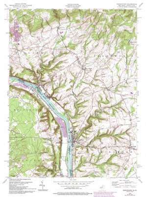
Frenchtown Topo Map New Jersey
To zoom in, hover over the map of Frenchtown
USGS Topo Quad 40075e1 - 1:24,000 scale
| Topo Map Name: | Frenchtown |
| USGS Topo Quad ID: | 40075e1 |
| Print Size: | ca. 21 1/4" wide x 27" high |
| Southeast Coordinates: | 40.5° N latitude / 75° W longitude |
| Map Center Coordinates: | 40.5625° N latitude / 75.0625° W longitude |
| U.S. States: | NJ, PA |
| Filename: | o40075e1.jpg |
| Download Map JPG Image: | Frenchtown topo map 1:24,000 scale |
| Map Type: | Topographic |
| Topo Series: | 7.5´ |
| Map Scale: | 1:24,000 |
| Source of Map Images: | United States Geological Survey (USGS) |
| Alternate Map Versions: |
Frenchtown NJ 1953 Download PDF Buy paper map Frenchtown NJ 1955, updated 1956 Download PDF Buy paper map Frenchtown NJ 1955, updated 1962 Download PDF Buy paper map Frenchtown NJ 1955, updated 1972 Download PDF Buy paper map Frenchtown NJ 1955, updated 1981 Download PDF Buy paper map Frenchtown NJ 1955, updated 1994 Download PDF Buy paper map Frenchtown NJ 1997, updated 1999 Download PDF Buy paper map Frenchtown NJ 2011 Download PDF Buy paper map Frenchtown NJ 2014 Download PDF Buy paper map Frenchtown NJ 2016 Download PDF Buy paper map |
1:24,000 Topo Quads surrounding Frenchtown
> Back to 40075e1 at 1:100,000 scale
> Back to 40074a1 at 1:250,000 scale
> Back to U.S. Topo Maps home
Frenchtown topo map: Gazetteer
Frenchtown: Airports
Alexandria Airport elevation 142m 465′Cumulus Ridge elevation 205m 672′
Erkes Airport elevation 107m 351′
Erwinna Private Airport elevation 107m 351′
Herr Brothers Airport elevation 89m 291′
Malone Airport elevation 127m 416′
Sullivan Airport elevation 107m 351′
Tinicum Farms Heliport elevation 172m 564′
Frenchtown: Bridges
Erwinna Covered Bridge elevation 37m 121′Uhlerstown Covered Bridge elevation 36m 118′
Frenchtown: Dams
Nishisakawick Creek Dam elevation 184m 603′Frenchtown: Islands
Pennington Island elevation 37m 121′Frenchtown: Parks
Delaware Canal State Park elevation 115m 377′Tinicum County Park elevation 36m 118′
Frenchtown: Populated Places
Baptistown elevation 157m 515′Chestnut Ridge Acres elevation 178m 583′
Clay Ridge elevation 158m 518′
Erwinna elevation 41m 134′
Everbreeze Plateau elevation 122m 400′
Everittstown elevation 102m 334′
Frenchtown elevation 43m 141′
Golden Acres Estates elevation 138m 452′
Jugtown elevation 43m 141′
Little York elevation 109m 357′
Lodi elevation 37m 121′
Milford elevation 39m 127′
Mount Pleasant elevation 90m 295′
Palmyra elevation 143m 469′
Riegel Ridge elevation 188m 616′
Ruppletown elevation 157m 515′
Spring Mills elevation 88m 288′
Uhlerstown elevation 36m 118′
Upper Black Eddy elevation 37m 121′
Frenchtown: Reservoirs
Camp Marudy Lake elevation 184m 603′Frenchtown: Streams
Copper Creek elevation 33m 108′Hakihokake Creek elevation 36m 118′
Harihokake Creek elevation 36m 118′
Little Nishisakawick Creek elevation 36m 118′
Nishisakawick Creek elevation 36m 118′
Swamp Creek elevation 36m 118′
Frenchtown: Valleys
Hermit Hollow elevation 134m 439′Sweet Hollow elevation 120m 393′
Frenchtown digital topo map on disk
Buy this Frenchtown topo map showing relief, roads, GPS coordinates and other geographical features, as a high-resolution digital map file on DVD:
Atlantic Coast (NY, NJ, PA, DE, MD, VA, NC)
Buy digital topo maps: Atlantic Coast (NY, NJ, PA, DE, MD, VA, NC)


