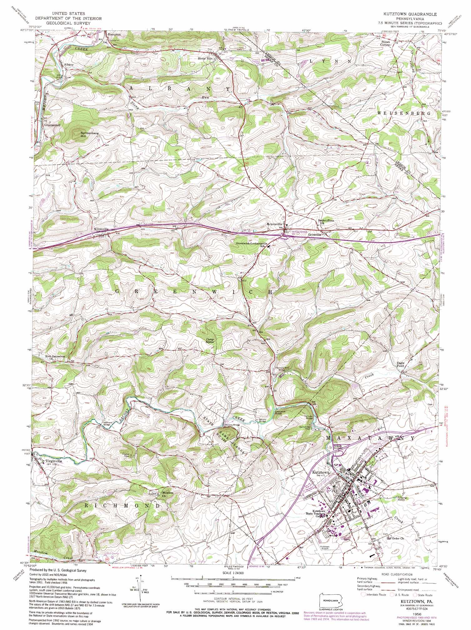
Kutztown Topo Map Pennsylvania
To zoom in, hover over the map of Kutztown
USGS Topo Quad 40075e7 - 1:24,000 scale
| Topo Map Name: | Kutztown |
| USGS Topo Quad ID: | 40075e7 |
| Print Size: | ca. 21 1/4" wide x 27" high |
| Southeast Coordinates: | 40.5° N latitude / 75.75° W longitude |
| Map Center Coordinates: | 40.5625° N latitude / 75.8125° W longitude |
| U.S. State: | PA |
| Filename: | o40075e7.jpg |
| Download Map JPG Image: | Kutztown topo map 1:24,000 scale |
| Map Type: | Topographic |
| Topo Series: | 7.5´ |
| Map Scale: | 1:24,000 |
| Source of Map Images: | United States Geological Survey (USGS) |
| Alternate Map Versions: |
Kutztown PA 1956, updated 1957 Download PDF Buy paper map Kutztown PA 1956, updated 1961 Download PDF Buy paper map Kutztown PA 1956, updated 1971 Download PDF Buy paper map Kutztown PA 1956, updated 1977 Download PDF Buy paper map Kutztown PA 1956, updated 1986 Download PDF Buy paper map Kutztown PA 1956, updated 1994 Download PDF Buy paper map Kutztown PA 1997, updated 1999 Download PDF Buy paper map Kutztown PA 2010 Download PDF Buy paper map Kutztown PA 2013 Download PDF Buy paper map Kutztown PA 2016 Download PDF Buy paper map |
1:24,000 Topo Quads surrounding Kutztown
Delano |
Tamaqua |
Nesquehoning |
Lehighton |
Palmerton |
Orwigsburg |
New Ringgold |
New Tripoli |
Slatedale |
Cementon |
Auburn |
Hamburg |
Kutztown |
Topton |
Allentown West |
Bernville |
Temple |
Fleetwood |
Manatawny |
East Greenville |
Sinking Spring |
Reading |
Birdsboro |
Boyertown |
Sassamansville |
> Back to 40075e1 at 1:100,000 scale
> Back to 40074a1 at 1:250,000 scale
> Back to U.S. Topo Maps home
Kutztown topo map: Gazetteer
Kutztown: Airports
Kutztown Airpark elevation 146m 479′Kutztown: Bridges
Deturks Bridge elevation 118m 387′Dietrichs Mill Bridge elevation 118m 387′
Greenwich Bridge elevation 112m 367′
Heffners Bridge elevation 102m 334′
Sacony Bridge elevation 110m 360′
Saucony Bridge elevation 109m 357′
Kutztown: Parks
Kutztown Park elevation 141m 462′State Game Lands Number 182 elevation 132m 433′
University Field elevation 141m 462′
Kutztown: Populated Places
Albany elevation 124m 406′Eagle Point elevation 135m 442′
Greenawald elevation 124m 406′
Grimville elevation 226m 741′
Highland Estates Mobile Home Park elevation 193m 633′
Klinesville elevation 131m 429′
Krumsville elevation 231m 757′
Kutztown elevation 128m 419′
Stines Corner elevation 217m 711′
Stony Run elevation 201m 659′
Virginville elevation 102m 334′
Kutztown: Post Offices
Kutztown Post Office elevation 130m 426′Kutztown: Reservoirs
Kutztown Swimming Pool elevation 122m 400′Kutztown: Streams
Mill Creek elevation 111m 364′Pine Creek elevation 117m 383′
Sacony Creek elevation 94m 308′
Stony Run elevation 119m 390′
Kutztown: Summits
Spitzenberg Hill elevation 322m 1056′Kutztown digital topo map on disk
Buy this Kutztown topo map showing relief, roads, GPS coordinates and other geographical features, as a high-resolution digital map file on DVD:
Atlantic Coast (NY, NJ, PA, DE, MD, VA, NC)
Buy digital topo maps: Atlantic Coast (NY, NJ, PA, DE, MD, VA, NC)
 map DVD")