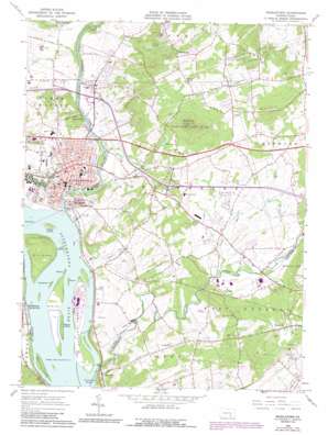
Middletown Topo Map Pennsylvania
To zoom in, hover over the map of Middletown
USGS Topo Quad 40076b6 - 1:24,000 scale
| Topo Map Name: | Middletown |
| USGS Topo Quad ID: | 40076b6 |
| Print Size: | ca. 21 1/4" wide x 27" high |
| Southeast Coordinates: | 40.125° N latitude / 76.625° W longitude |
| Map Center Coordinates: | 40.1875° N latitude / 76.6875° W longitude |
| U.S. State: | PA |
| Filename: | o40076b6.jpg |
| Download Map JPG Image: | Middletown topo map 1:24,000 scale |
| Map Type: | Topographic |
| Topo Series: | 7.5´ |
| Map Scale: | 1:24,000 |
| Source of Map Images: | United States Geological Survey (USGS) |
| Alternate Map Versions: |
Middletown PA 1963, updated 1965 Download PDF Buy paper map Middletown PA 1963, updated 1972 Download PDF Buy paper map Middletown PA 1963, updated 1973 Download PDF Buy paper map Middletown PA 1963, updated 1990 Download PDF Buy paper map Middletown PA 1963, updated 1990 Download PDF Buy paper map Middletown PA 1999, updated 2001 Download PDF Buy paper map Middletown PA 2010 Download PDF Buy paper map Middletown PA 2013 Download PDF Buy paper map Middletown PA 2016 Download PDF Buy paper map |
1:24,000 Topo Quads surrounding Middletown
> Back to 40076a1 at 1:100,000 scale
> Back to 40076a1 at 1:250,000 scale
> Back to U.S. Topo Maps home
Middletown topo map: Gazetteer
Middletown: Airports
Ecko Field elevation 110m 360′Metropolitan Edison Three Mile Island Heliport elevation 111m 364′
Three Mile Island Number Two Airport elevation 91m 298′
Middletown: Dams
Lewis Dam elevation 116m 380′Round Top Dam elevation 152m 498′
York Haven Dam elevation 79m 259′
Middletown: Falls
Conewago Falls elevation 79m 259′Middletown: Islands
Bashore Island elevation 86m 282′Beech Island elevation 86m 282′
Fall Island elevation 84m 275′
Goosehorn Island elevation 85m 278′
Henry Island elevation 86m 282′
Hill Island elevation 116m 380′
Kohr Island elevation 84m 275′
Poplar Island elevation 86m 282′
Shelley Island elevation 87m 285′
Threemile Island elevation 91m 298′
Middletown: Parks
Conoy Township Park elevation 156m 511′Shank Park elevation 188m 616′
State Game Land Number 246 elevation 264m 866′
Swatara Park elevation 105m 344′
Middletown: Populated Places
Braeburn elevation 134m 439′Clifton elevation 96m 314′
Coldsborough Manor elevation 101m 331′
Conewago elevation 128m 419′
Crest View elevation 135m 442′
Edgewood Hills elevation 212m 695′
Falmouth elevation 109m 357′
Freys Grove elevation 91m 298′
Hickory Ridge elevation 160m 524′
Hillsdale Acres elevation 121m 396′
Laurel Woods elevation 216m 708′
Middletown elevation 110m 360′
Newville elevation 168m 551′
Pine Manor elevation 123m 403′
Round Top Manor elevation 111m 364′
Royalton elevation 90m 295′
Sandhill elevation 200m 656′
Spot Mobile Home Park elevation 130m 426′
Waltonville elevation 213m 698′
Wood Ridge Manor elevation 223m 731′
Middletown: Post Offices
Falmouth Post Office (historical) elevation 109m 357′Middletown: Reservoirs
Lewis Lake elevation 116m 380′Middletown Reservoir elevation 138m 452′
Round Top Impoundment elevation 152m 498′
Middletown: Streams
Brills Run elevation 114m 374′Conewago Creek elevation 84m 275′
Fishing Creek elevation 84m 275′
Iron Run elevation 90m 295′
Lynch Run elevation 111m 364′
Swatara Creek elevation 84m 275′
Middletown: Summits
Round Top elevation 281m 921′Middletown digital topo map on disk
Buy this Middletown topo map showing relief, roads, GPS coordinates and other geographical features, as a high-resolution digital map file on DVD:
Atlantic Coast (NY, NJ, PA, DE, MD, VA, NC)
Buy digital topo maps: Atlantic Coast (NY, NJ, PA, DE, MD, VA, NC)


