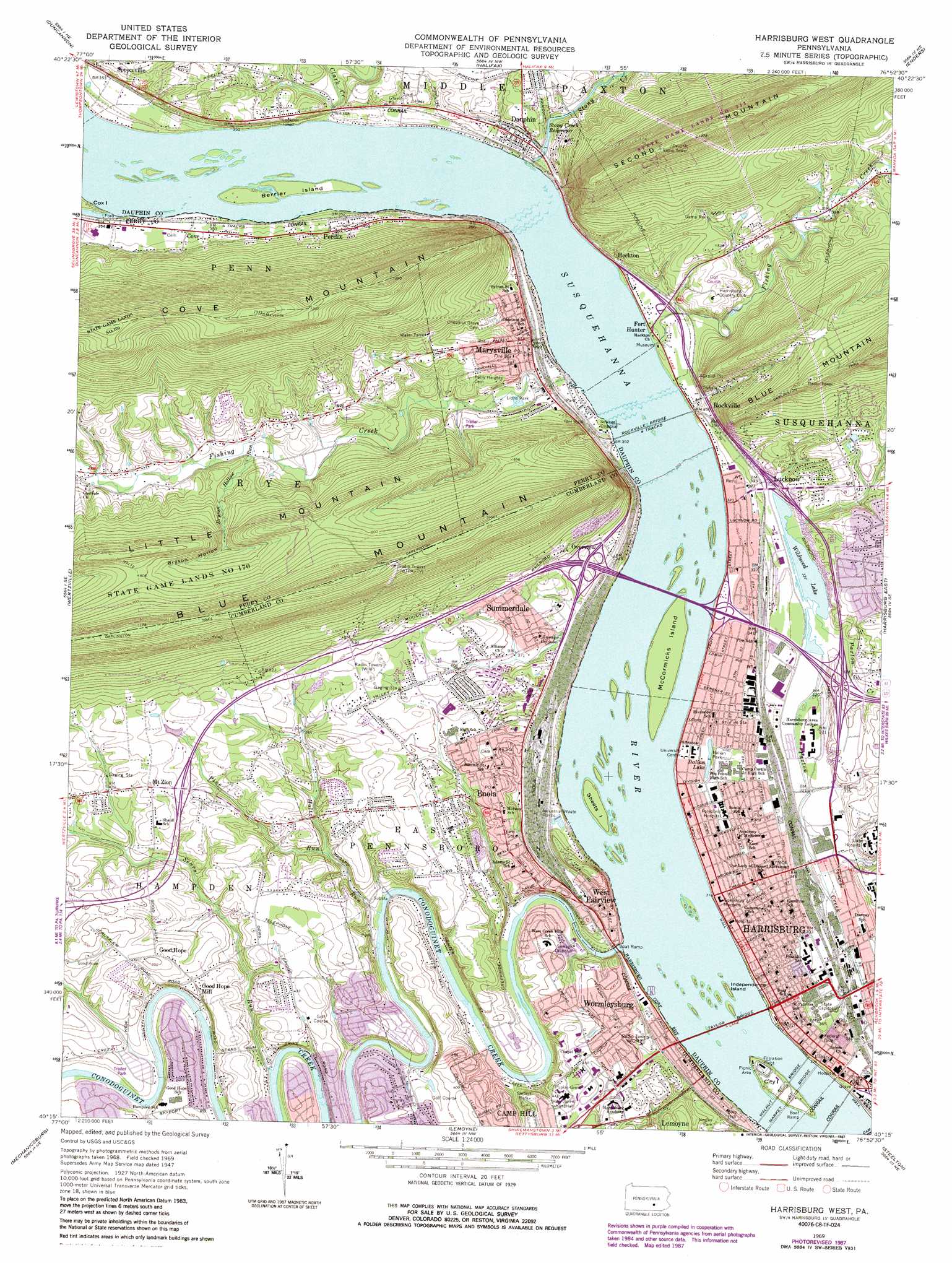
Harrisburg West Topo Map Pennsylvania
To zoom in, hover over the map of Harrisburg West
USGS Topo Quad 40076c8 - 1:24,000 scale
| Topo Map Name: | Harrisburg West |
| USGS Topo Quad ID: | 40076c8 |
| Print Size: | ca. 21 1/4" wide x 27" high |
| Southeast Coordinates: | 40.25° N latitude / 76.875° W longitude |
| Map Center Coordinates: | 40.3125° N latitude / 76.9375° W longitude |
| U.S. State: | PA |
| Filename: | o40076c8.jpg |
| Download Map JPG Image: | Harrisburg West topo map 1:24,000 scale |
| Map Type: | Topographic |
| Topo Series: | 7.5´ |
| Map Scale: | 1:24,000 |
| Source of Map Images: | United States Geological Survey (USGS) |
| Alternate Map Versions: |
Harrisburg West PA 1947 Download PDF Buy paper map Harrisburg West PA 1947 Download PDF Buy paper map Harrisburg West PA 1947, updated 1947 Download PDF Buy paper map Harrisburg West PA 1963, updated 1963 Download PDF Buy paper map Harrisburg West PA 1969, updated 1972 Download PDF Buy paper map Harrisburg West PA 1969, updated 1977 Download PDF Buy paper map Harrisburg West PA 1969, updated 1987 Download PDF Buy paper map Harrisburg West PA 1969, updated 1987 Download PDF Buy paper map Harrisburg West PA 1993, updated 1999 Download PDF Buy paper map Harrisburg West PA 2010 Download PDF Buy paper map Harrisburg West PA 2013 Download PDF Buy paper map Harrisburg West PA 2016 Download PDF Buy paper map |
1:24,000 Topo Quads surrounding Harrisburg West
Millerstown |
Reward |
Millersburg |
Elizabethville |
Lykens |
Newport |
Duncannon |
Halifax |
Enders |
Grantville |
Shermans Dale |
Wertzville |
Harrisburg West |
Harrisburg East |
Hershey |
Carlisle |
Mechanicsburg |
Lemoyne |
Steelton |
Middletown |
Mount Holly Springs |
Dillsburg |
Wellsville |
Dover |
York Haven |
> Back to 40076a1 at 1:100,000 scale
> Back to 40076a1 at 1:250,000 scale
> Back to U.S. Topo Maps home
Harrisburg West topo map: Gazetteer
Harrisburg West: Airports
Harsco Heliport elevation 118m 387′Holy Spirit Heliport elevation 133m 436′
Mount View Airfield (historical) elevation 134m 439′
Mount View Airport elevation 140m 459′
Harrisburg West: Bridges
George N Wade Bridge elevation 85m 278′Market Street Bridge elevation 96m 314′
Memorial Bridge elevation 94m 308′
Rockville Bridge elevation 91m 298′
Taylor Bridge elevation 85m 278′
Walnut Bridge elevation 94m 308′
Harrisburg West: Dams
Wildwood Dam elevation 109m 357′Harrisburg West: Islands
Berrier Island elevation 97m 318′City 1 elevation 96m 314′
City Island elevation 96m 314′
Independence Island elevation 91m 298′
McCormicks Island elevation 91m 298′
Sheets Island elevation 91m 298′
Harrisburg West: Lakes
Italian Lake elevation 103m 337′Wildwood Lake elevation 98m 321′
Harrisburg West: Parks
Adam Ricci Community Park elevation 144m 472′Braxton Park elevation 109m 357′
Delaware and Wallace Park elevation 109m 357′
Fourth and Dauphin Park elevation 104m 341′
Gorgas Park elevation 111m 364′
Italian Park elevation 106m 347′
Lions Park elevation 107m 351′
Negly Park elevation 133m 436′
Penn and Dauphin Park elevation 99m 324′
Penn and Sayford Park elevation 99m 324′
Seventh and Radnor Park elevation 110m 360′
State Game Land No. 319 elevation 97m 318′
State Game Lands No 211 elevation 402m 1318′
Wildwood Lake Nature Center elevation 101m 331′
Wildwood Park elevation 107m 351′
Harrisburg West: Populated Places
Beaufort Farms elevation 116m 380′Cove elevation 111m 364′
Coventry Close elevation 121m 396′
Coxtown (historical) elevation 98m 321′
Dauphin elevation 111m 364′
Enola elevation 136m 446′
Fort Hunter elevation 98m 321′
Fox Ridge Court elevation 102m 334′
Glenvale elevation 139m 456′
Good Hope elevation 149m 488′
Good Hope Mill elevation 126m 413′
Grandview Acres elevation 146m 479′
Hampden Village Mobile Home Park elevation 117m 383′
Harrisburg elevation 102m 334′
Heckton elevation 107m 351′
Hillside Village elevation 102m 334′
Jackson Lick elevation 104m 341′
Kingwood elevation 123m 403′
Knob Point elevation 135m 442′
Lucknow elevation 136m 446′
Marysville elevation 114m 374′
Montrose Park elevation 102m 334′
Mount View elevation 134m 439′
Mount Zion elevation 140m 459′
Mountain Dale elevation 188m 616′
Mountain View Estates elevation 136m 446′
Overview elevation 160m 524′
Perdix elevation 134m 439′
Ridgeland elevation 131m 429′
Rockville elevation 100m 328′
Sherwood Park elevation 137m 449′
Speeceville elevation 138m 452′
Summerdale elevation 116m 380′
Treemont elevation 132m 433′
West Creek Hills elevation 121m 396′
West Enola elevation 139m 456′
West Fairview elevation 101m 331′
Westwood Village elevation 137m 449′
Windsor Farms elevation 138m 452′
Wormleysburg elevation 135m 442′
Harrisburg West: Reservoirs
Stony Creek Reservoir elevation 107m 351′Harrisburg West: Streams
Asylum Run elevation 95m 311′Boyer Run elevation 114m 374′
Bryson Hollow Run elevation 135m 442′
Clark Creek elevation 98m 321′
Conodoguinet Creek elevation 85m 278′
Fishing Creek elevation 97m 318′
Fishing Creek elevation 93m 305′
Holtz Run elevation 91m 298′
Lambs Gap Run elevation 124m 406′
Pine Run elevation 107m 351′
Sears Run elevation 98m 321′
Starry Brook elevation 116m 380′
Stony Creek elevation 97m 318′
University Run elevation 85m 278′
Harrisburg West: Valleys
Bryson Hollow elevation 127m 416′Harrisburg West digital topo map on disk
Buy this Harrisburg West topo map showing relief, roads, GPS coordinates and other geographical features, as a high-resolution digital map file on DVD:
Atlantic Coast (NY, NJ, PA, DE, MD, VA, NC)
Buy digital topo maps: Atlantic Coast (NY, NJ, PA, DE, MD, VA, NC)
 map DVD")