Bethel Topo Map Pennsylvania
To zoom in, hover over the map of Bethel
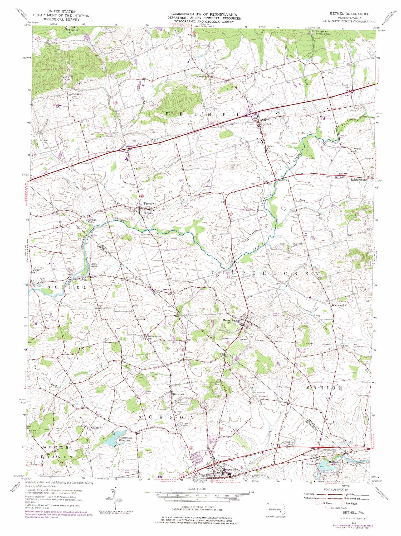
USGS Topo Quad 40076d3 - 1:24,000 scale
| Topo Map Name: | Bethel |
| USGS Topo Quad ID: | 40076d3 |
| Print Size: | ca. 21 1/4" wide x 27" high |
| Southeast Coordinates: | 40.375° N latitude / 76.25° W longitude |
| Map Center Coordinates: | 40.4375° N latitude / 76.3125° W longitude |
| U.S. State: | PA |
| Filename: | o40076d3.jpg |
| Download Map JPG Image: | Bethel topo map 1:24,000 scale |
| Map Type: | Topographic |
| Topo Series: | 7.5´ |
| Map Scale: | 1:24,000 |
| Source of Map Images: | United States Geological Survey (USGS) |
| Alternate Map Versions: |
Bethel PA 1955, updated 1956 Download PDF Buy paper map Bethel PA 1955, updated 1969 Download PDF Buy paper map Bethel PA 1955, updated 1970 Download PDF Buy paper map Bethel PA 1955, updated 1977 Download PDF Buy paper map Bethel PA 1992, updated 1995 Download PDF Buy paper map Bethel PA 2010 Download PDF Buy paper map Bethel PA 2013 Download PDF Buy paper map Bethel PA 2016 Download PDF Buy paper map |
1:24,000 Topo Quads surrounding Bethel
Valley View |
Tremont |
Minersville |
Pottsville |
Orwigsburg |
Tower City |
Pine Grove |
Swatara Hill |
Friedensburg |
Auburn |
Indiantown Gap |
Fredericksburg |
Bethel |
Strausstown |
Bernville |
Palmyra |
Lebanon |
Richland |
Womelsdorf |
Sinking Spring |
Elizabethtown |
Manheim |
Lititz |
Ephrata |
Terre Hill |
> Back to 40076a1 at 1:100,000 scale
> Back to 40076a1 at 1:250,000 scale
> Back to U.S. Topo Maps home
Bethel topo map: Gazetteer
Bethel: Airports
Grimes Airport elevation 177m 580′Krill Airport elevation 162m 531′
Bethel: Canals
Union Canal elevation 120m 393′Bethel: Dams
Stacks Dam elevation 153m 501′Stracks Dam elevation 160m 524′
Bethel: Lakes
Millards Quarry Pond elevation 122m 400′Bethel: Parks
Frystown Lions Park elevation 152m 498′Sportsman Park elevation 204m 669′
Bethel: Populated Places
Bethel elevation 171m 561′Crosskill Mills elevation 145m 475′
Frystown elevation 143m 469′
Greble elevation 136m 446′
Kutztown elevation 200m 656′
Millardsville elevation 148m 485′
Mount Aetna elevation 190m 623′
Nacetown elevation 187m 613′
Sun Valley Mobile Home Park elevation 183m 600′
Wintersville elevation 171m 561′
Bethel: Post Offices
Bethel Post Office (historical) elevation 171m 561′Bethel: Reservoirs
Myerstown Reservoir elevation 152m 498′Bethel: Streams
Crosskill Creek elevation 133m 436′Mill Creek elevation 151m 495′
Owl Creek elevation 128m 419′
Bethel digital topo map on disk
Buy this Bethel topo map showing relief, roads, GPS coordinates and other geographical features, as a high-resolution digital map file on DVD:
Atlantic Coast (NY, NJ, PA, DE, MD, VA, NC)
Buy digital topo maps: Atlantic Coast (NY, NJ, PA, DE, MD, VA, NC)
 map DVD")