Swatara Hill Topo Map Pennsylvania
To zoom in, hover over the map of Swatara Hill
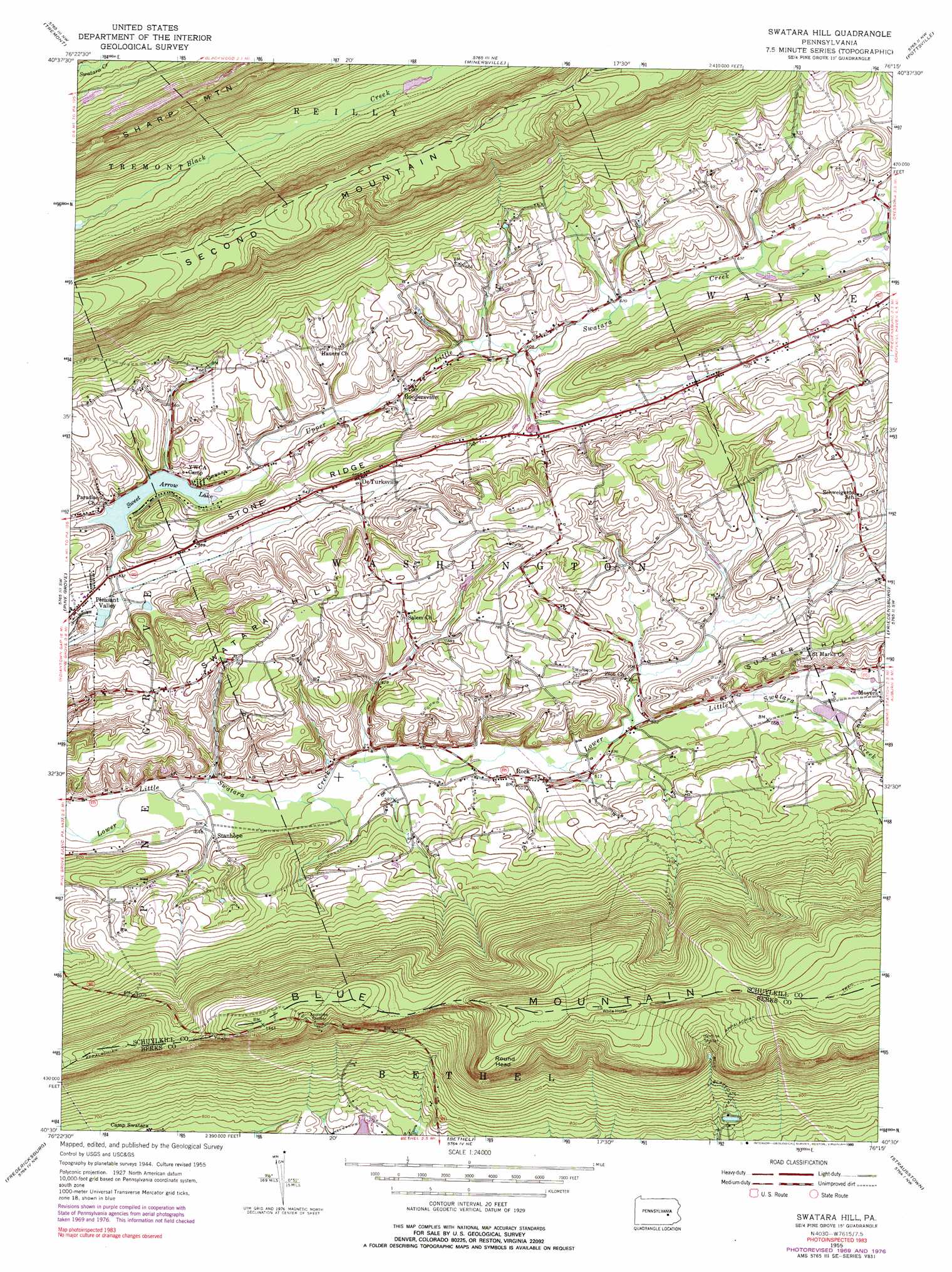
USGS Topo Quad 40076e3 - 1:24,000 scale
| Topo Map Name: | Swatara Hill |
| USGS Topo Quad ID: | 40076e3 |
| Print Size: | ca. 21 1/4" wide x 27" high |
| Southeast Coordinates: | 40.5° N latitude / 76.25° W longitude |
| Map Center Coordinates: | 40.5625° N latitude / 76.3125° W longitude |
| U.S. State: | PA |
| Filename: | o40076e3.jpg |
| Download Map JPG Image: | Swatara Hill topo map 1:24,000 scale |
| Map Type: | Topographic |
| Topo Series: | 7.5´ |
| Map Scale: | 1:24,000 |
| Source of Map Images: | United States Geological Survey (USGS) |
| Alternate Map Versions: |
Swatara Hill PA 1955, updated 1956 Download PDF Buy paper map Swatara Hill PA 1955, updated 1968 Download PDF Buy paper map Swatara Hill PA 1955, updated 1971 Download PDF Buy paper map Swatara Hill PA 1955, updated 1977 Download PDF Buy paper map Swatara Hill PA 1955, updated 1990 Download PDF Buy paper map Swatara Hill PA 1955, updated 1990 Download PDF Buy paper map Swatara Hill PA 2010 Download PDF Buy paper map Swatara Hill PA 2013 Download PDF Buy paper map Swatara Hill PA 2016 Download PDF Buy paper map |
1:24,000 Topo Quads surrounding Swatara Hill
Shamokin |
Mount Carmel |
Ashland |
Shenandoah |
Delano |
Valley View |
Tremont |
Minersville |
Pottsville |
Orwigsburg |
Tower City |
Pine Grove |
Swatara Hill |
Friedensburg |
Auburn |
Indiantown Gap |
Fredericksburg |
Bethel |
Strausstown |
Bernville |
Palmyra |
Lebanon |
Richland |
Womelsdorf |
Sinking Spring |
> Back to 40076e1 at 1:100,000 scale
> Back to 40076a1 at 1:250,000 scale
> Back to U.S. Topo Maps home
Swatara Hill topo map: Gazetteer
Swatara Hill: Dams
Black Creek Intake Dam elevation 240m 787′Sweet Arrow Lake Dam elevation 165m 541′
Swatara Hill: Parks
State Game Lands Number 160 elevation 164m 538′Swatara Hill: Populated Places
De Turksville elevation 202m 662′Pleasant Valley elevation 163m 534′
Roedersville elevation 179m 587′
Round Head elevation 464m 1522′
Stanhope elevation 169m 554′
Swatara Hill: Reservoirs
Sweet Arrow Lake elevation 165m 541′Swatara Hill: Ridges
Stone Ridge elevation 210m 688′Swatara Hill: Streams
Conrad Weiser Branch elevation 158m 518′Iron Ore Run elevation 175m 574′
Schneck Run elevation 173m 567′
Spruce Run elevation 207m 679′
Upper Little Swatara Creek elevation 166m 544′
Swatara Hill: Summits
Summer Hill elevation 239m 784′Swatara Hill elevation 257m 843′
Swatara Hill: Trails
Blue Blazed Trail elevation 312m 1023′Foxs Path elevation 358m 1174′
Werts Path elevation 309m 1013′
Swatara Hill digital topo map on disk
Buy this Swatara Hill topo map showing relief, roads, GPS coordinates and other geographical features, as a high-resolution digital map file on DVD:
Atlantic Coast (NY, NJ, PA, DE, MD, VA, NC)
Buy digital topo maps: Atlantic Coast (NY, NJ, PA, DE, MD, VA, NC)
 map DVD")