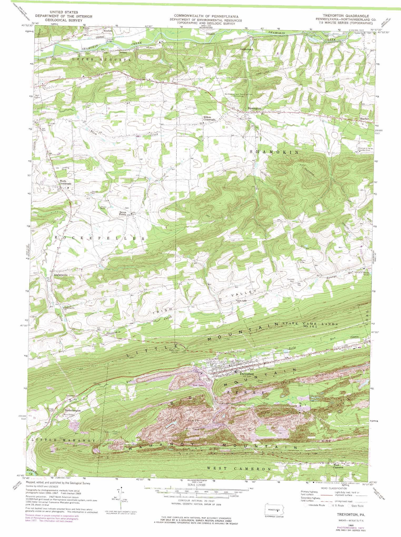
Trevorton Topo Map Pennsylvania
To zoom in, hover over the map of Trevorton
USGS Topo Quad 40076g6 - 1:24,000 scale
| Topo Map Name: | Trevorton |
| USGS Topo Quad ID: | 40076g6 |
| Print Size: | ca. 21 1/4" wide x 27" high |
| Southeast Coordinates: | 40.75° N latitude / 76.625° W longitude |
| Map Center Coordinates: | 40.8125° N latitude / 76.6875° W longitude |
| U.S. State: | PA |
| Filename: | o40076g6.jpg |
| Download Map JPG Image: | Trevorton topo map 1:24,000 scale |
| Map Type: | Topographic |
| Topo Series: | 7.5´ |
| Map Scale: | 1:24,000 |
| Source of Map Images: | United States Geological Survey (USGS) |
| Alternate Map Versions: |
Trevorton PA 1969, updated 1972 Download PDF Buy paper map Trevorton PA 1969, updated 1978 Download PDF Buy paper map Trevorton PA 2010 Download PDF Buy paper map Trevorton PA 2013 Download PDF Buy paper map Trevorton PA 2016 Download PDF Buy paper map |
1:24,000 Topo Quads surrounding Trevorton
Allenwood |
Milton |
Washingtonville |
Millville |
Bloomsburg |
Lewisburg |
Northumberland |
Riverside |
Danville |
Catawissa |
Freeburg |
Sunbury |
Trevorton |
Shamokin |
Mount Carmel |
Dalmatia |
Pillow |
Klingerstown |
Valley View |
Tremont |
Millersburg |
Elizabethville |
Lykens |
Tower City |
Pine Grove |
> Back to 40076e1 at 1:100,000 scale
> Back to 40076a1 at 1:250,000 scale
> Back to U.S. Topo Maps home
Trevorton topo map: Gazetteer
Trevorton: Airports
Corbins Airport elevation 196m 643′Trevorton: Dams
Sunshine Coal Company Number Sixteen Dam elevation 210m 688′Trevorton Plant Number One Dam elevation 221m 725′
Trevorton: Parks
State Game Lands Number 165 elevation 394m 1292′Trevorton: Populated Places
Augustaville elevation 192m 629′Dunkelbergers elevation 214m 702′
Farnsworth elevation 241m 790′
Mayfair elevation 224m 734′
Millers Crossroads elevation 202m 662′
Seven Points elevation 194m 636′
Stonington elevation 170m 557′
Trevorton elevation 256m 839′
West Cameron elevation 297m 974′
Wolfs Crossroads elevation 200m 656′
Yordy elevation 239m 784′
Trevorton: Reservoirs
Sunshine Fines Pond elevation 210m 688′Trevorton Fines Pond elevation 221m 725′
Trevorton: Summits
Big Mountain elevation 402m 1318′Trevorton: Trails
James Path elevation 371m 1217′Trevorton digital topo map on disk
Buy this Trevorton topo map showing relief, roads, GPS coordinates and other geographical features, as a high-resolution digital map file on DVD:
Atlantic Coast (NY, NJ, PA, DE, MD, VA, NC)
Buy digital topo maps: Atlantic Coast (NY, NJ, PA, DE, MD, VA, NC)
 map DVD")