Lewisburg Topo Map Pennsylvania
To zoom in, hover over the map of Lewisburg
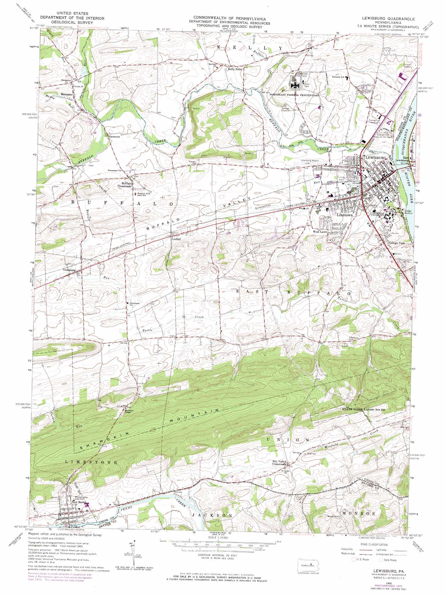
USGS Topo Quad 40076h8 - 1:24,000 scale
| Topo Map Name: | Lewisburg |
| USGS Topo Quad ID: | 40076h8 |
| Print Size: | ca. 21 1/4" wide x 27" high |
| Southeast Coordinates: | 40.875° N latitude / 76.875° W longitude |
| Map Center Coordinates: | 40.9375° N latitude / 76.9375° W longitude |
| U.S. State: | PA |
| Filename: | o40076h8.jpg |
| Download Map JPG Image: | Lewisburg topo map 1:24,000 scale |
| Map Type: | Topographic |
| Topo Series: | 7.5´ |
| Map Scale: | 1:24,000 |
| Source of Map Images: | United States Geological Survey (USGS) |
| Alternate Map Versions: |
Lewisburg PA 1965, updated 1967 Download PDF Buy paper map Lewisburg PA 1965, updated 1973 Download PDF Buy paper map Lewisburg PA 1994, updated 1996 Download PDF Buy paper map Lewisburg PA 2010 Download PDF Buy paper map Lewisburg PA 2013 Download PDF Buy paper map Lewisburg PA 2016 Download PDF Buy paper map |
1:24,000 Topo Quads surrounding Lewisburg
Linden |
Williamsport |
Montoursville South |
Muncy |
Hughesville |
Carroll |
Williamsport Se |
Allenwood |
Milton |
Washingtonville |
Hartleton |
Mifflinburg |
Lewisburg |
Northumberland |
Riverside |
Beavertown |
Middleburg |
Freeburg |
Sunbury |
Trevorton |
Beaver Springs |
Richfield |
Dalmatia |
Pillow |
Klingerstown |
> Back to 40076e1 at 1:100,000 scale
> Back to 40076a1 at 1:250,000 scale
> Back to U.S. Topo Maps home
Lewisburg topo map: Gazetteer
Lewisburg: Airports
Lewisburg Airfield elevation 142m 465′Lewisburg: Bridges
Harner Bridge elevation 140m 459′Lewisburg: Parks
Green Park elevation 138m 452′Huenzgle Park elevation 140m 459′
Saint Anthonys Street Park elevation 134m 439′
State Game Lands Number 193 elevation 212m 695′
Lewisburg: Populated Places
Bucknell elevation 141m 462′Buffalo Crossroads elevation 158m 518′
Cameron elevation 158m 518′
College Park elevation 158m 518′
Dry Valley Crossroads elevation 180m 590′
Fairville elevation 147m 482′
Kelly Point elevation 145m 475′
Lewisburg elevation 144m 472′
Linntown elevation 143m 469′
Lochiel elevation 164m 538′
Mazeppa elevation 157m 515′
New Berlin elevation 166m 544′
Vicksburg elevation 162m 531′
West Lawn elevation 147m 482′
Lewisburg: Streams
Beaver Run elevation 152m 498′Black Run elevation 152m 498′
Limestone Run elevation 128m 419′
Little Buffalo Creek elevation 138m 452′
Mill Race elevation 134m 439′
Miller Run elevation 128m 419′
Muddy Run elevation 150m 492′
Spruce Run elevation 148m 485′
Lewisburg: Summits
Shamokin Mountain elevation 333m 1092′Lewisburg: Valleys
Buffalo Valley elevation 142m 465′Lewisburg digital topo map on disk
Buy this Lewisburg topo map showing relief, roads, GPS coordinates and other geographical features, as a high-resolution digital map file on DVD:
Atlantic Coast (NY, NJ, PA, DE, MD, VA, NC)
Buy digital topo maps: Atlantic Coast (NY, NJ, PA, DE, MD, VA, NC)
 map DVD")