Plainfield Topo Map Pennsylvania
To zoom in, hover over the map of Plainfield
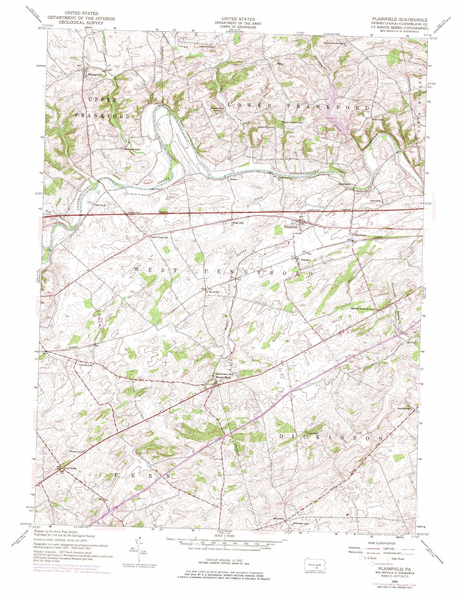
USGS Topo Quad 40077b3 - 1:24,000 scale
| Topo Map Name: | Plainfield |
| USGS Topo Quad ID: | 40077b3 |
| Print Size: | ca. 21 1/4" wide x 27" high |
| Southeast Coordinates: | 40.125° N latitude / 77.25° W longitude |
| Map Center Coordinates: | 40.1875° N latitude / 77.3125° W longitude |
| U.S. State: | PA |
| Filename: | o40077b3.jpg |
| Download Map JPG Image: | Plainfield topo map 1:24,000 scale |
| Map Type: | Topographic |
| Topo Series: | 7.5´ |
| Map Scale: | 1:24,000 |
| Source of Map Images: | United States Geological Survey (USGS) |
| Alternate Map Versions: |
Plainfield PA 1952, updated 1958 Download PDF Buy paper map Plainfield PA 1952, updated 1970 Download PDF Buy paper map Plainfield PA 1952, updated 1978 Download PDF Buy paper map Plainfield PA 1999, updated 2001 Download PDF Buy paper map Plainfield PA 2010 Download PDF Buy paper map Plainfield PA 2013 Download PDF Buy paper map Plainfield PA 2016 Download PDF Buy paper map |
1:24,000 Topo Quads surrounding Plainfield
Mccoysville |
Spruce Hill |
Ickesburg |
Newport |
Duncannon |
Blain |
Andersonburg |
Landisburg |
Shermans Dale |
Wertzville |
Newburg |
Newville |
Plainfield |
Carlisle |
Mechanicsburg |
Shippensburg |
Walnut Bottom |
Dickinson |
Mount Holly Springs |
Dillsburg |
Scotland |
Caledonia Park |
Arendtsville |
Biglerville |
Hampton |
> Back to 40077a1 at 1:100,000 scale
> Back to 40076a1 at 1:250,000 scale
> Back to U.S. Topo Maps home
Plainfield topo map: Gazetteer
Plainfield: Airports
Lash Airport elevation 143m 469′Plainfield: Dams
Black Dam elevation 140m 459′Opossum Lake Dam elevation 148m 485′
Plainfield: Populated Places
Bears Crossroads elevation 147m 482′Blosserville elevation 181m 593′
Elliotts Mill elevation 144m 472′
Elliottson elevation 152m 498′
Greason elevation 155m 508′
Grieder elevation 140m 459′
Keiters Mill elevation 138m 452′
Kerrsville elevation 158m 518′
Mooredale elevation 191m 626′
Mount Rock elevation 168m 551′
Plainfield elevation 151m 495′
West Hill elevation 143m 469′
Plainfield: Reservoirs
Opossum Lake elevation 138m 452′Plainfield: Springs
Alexander Spring elevation 165m 541′Mount Rock Spring elevation 161m 528′
Plainfield: Streams
Bloser Creek elevation 137m 449′Locust Creek elevation 134m 439′
Mount Rock Spring Creek elevation 134m 439′
Opossum Creek elevation 130m 426′
Rock Run elevation 140m 459′
West Branch Mount Rock Spring Creek elevation 158m 518′
Plainfield digital topo map on disk
Buy this Plainfield topo map showing relief, roads, GPS coordinates and other geographical features, as a high-resolution digital map file on DVD:
Atlantic Coast (NY, NJ, PA, DE, MD, VA, NC)
Buy digital topo maps: Atlantic Coast (NY, NJ, PA, DE, MD, VA, NC)
 map DVD")