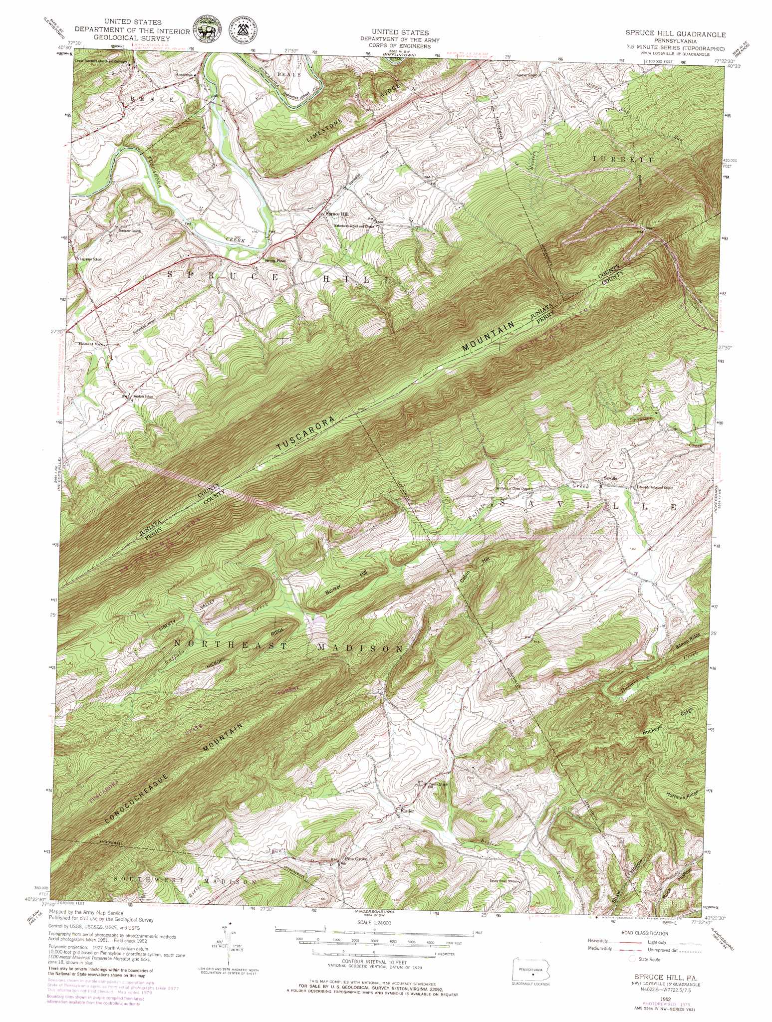
Spruce Hill Topo Map Pennsylvania
To zoom in, hover over the map of Spruce Hill
USGS Topo Quad 40077d4 - 1:24,000 scale
| Topo Map Name: | Spruce Hill |
| USGS Topo Quad ID: | 40077d4 |
| Print Size: | ca. 21 1/4" wide x 27" high |
| Southeast Coordinates: | 40.375° N latitude / 77.375° W longitude |
| Map Center Coordinates: | 40.4375° N latitude / 77.4375° W longitude |
| U.S. State: | PA |
| Filename: | o40077d4.jpg |
| Download Map JPG Image: | Spruce Hill topo map 1:24,000 scale |
| Map Type: | Topographic |
| Topo Series: | 7.5´ |
| Map Scale: | 1:24,000 |
| Source of Map Images: | United States Geological Survey (USGS) |
| Alternate Map Versions: |
Spruce Hill PA 1952, updated 1958 Download PDF Buy paper map Spruce Hill PA 1952, updated 1971 Download PDF Buy paper map Spruce Hill PA 1952, updated 1977 Download PDF Buy paper map Spruce Hill PA 1952, updated 1979 Download PDF Buy paper map Spruce Hill PA 2010 Download PDF Buy paper map Spruce Hill PA 2013 Download PDF Buy paper map Spruce Hill PA 2016 Download PDF Buy paper map |
1:24,000 Topo Quads surrounding Spruce Hill
Barrville |
Burnham |
Alfarata |
Mcclure |
Beaver Springs |
Belleville |
Lewistown |
Mifflintown |
Mexico |
Millerstown |
Mcveytown |
Mccoysville |
Spruce Hill |
Ickesburg |
Newport |
Blairs Mills |
Blain |
Andersonburg |
Landisburg |
Shermans Dale |
Doylesburg |
Newburg |
Newville |
Plainfield |
Carlisle |
> Back to 40077a1 at 1:100,000 scale
> Back to 40076a1 at 1:250,000 scale
> Back to U.S. Topo Maps home
Spruce Hill topo map: Gazetteer
Spruce Hill: Gaps
Run Gap elevation 571m 1873′Spruce Hill: Populated Places
Academia elevation 158m 518′Kistler elevation 205m 672′
Pine Grove elevation 215m 705′
Pleasant View elevation 168m 551′
Saville elevation 222m 728′
Seven Pines elevation 151m 495′
Spruce Hill elevation 152m 498′
Spruce Hill: Ridges
Buckeye Ridge elevation 362m 1187′Hickory Ridge elevation 341m 1118′
Hoffman Ridge elevation 360m 1181′
Spruce Hill: Streams
Doyle Run elevation 146m 479′Jinnie Gap Run elevation 149m 488′
Spruce Hill: Summits
Bunker Hill elevation 308m 1010′Cabin Hill elevation 363m 1190′
Spruce Hill: Trails
Yohn Trail elevation 424m 1391′Spruce Hill: Valleys
Liberty Valley elevation 277m 908′Spruce Hill digital topo map on disk
Buy this Spruce Hill topo map showing relief, roads, GPS coordinates and other geographical features, as a high-resolution digital map file on DVD:
Atlantic Coast (NY, NJ, PA, DE, MD, VA, NC)
Buy digital topo maps: Atlantic Coast (NY, NJ, PA, DE, MD, VA, NC)
 map DVD")