Mount Union Topo Map Pennsylvania
To zoom in, hover over the map of Mount Union
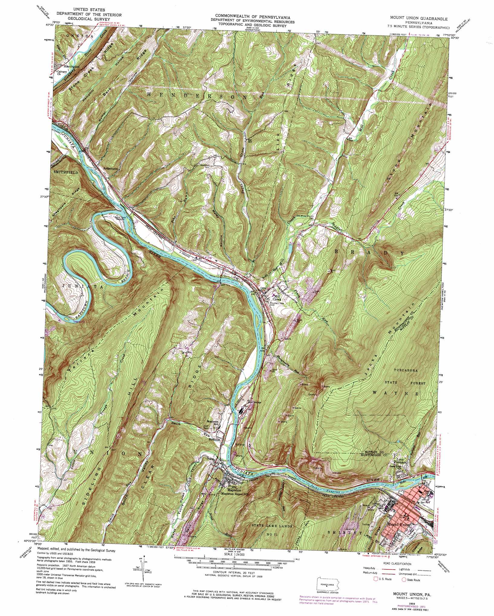
USGS Topo Quad 40077d8 - 1:24,000 scale
| Topo Map Name: | Mount Union |
| USGS Topo Quad ID: | 40077d8 |
| Print Size: | ca. 21 1/4" wide x 27" high |
| Southeast Coordinates: | 40.375° N latitude / 77.875° W longitude |
| Map Center Coordinates: | 40.4375° N latitude / 77.9375° W longitude |
| U.S. State: | PA |
| Filename: | o40077d8.jpg |
| Download Map JPG Image: | Mount Union topo map 1:24,000 scale |
| Map Type: | Topographic |
| Topo Series: | 7.5´ |
| Map Scale: | 1:24,000 |
| Source of Map Images: | United States Geological Survey (USGS) |
| Alternate Map Versions: |
Mount Union PA 1959, updated 1961 Download PDF Buy paper map Mount Union PA 1959, updated 1973 Download PDF Buy paper map Mount Union PA 1959, updated 1977 Download PDF Buy paper map Mount Union PA 2010 Download PDF Buy paper map Mount Union PA 2013 Download PDF Buy paper map Mount Union PA 2016 Download PDF Buy paper map |
1:24,000 Topo Quads surrounding Mount Union
Tyrone |
Franklinville |
Pine Grove Mills |
Mcalevys Fort |
Barrville |
Spruce Creek |
Alexandria |
Donation |
Allensville |
Belleville |
Williamsburg |
Huntingdon |
Mount Union |
Newton Hamilton |
Mcveytown |
Entriken |
Cassville |
Butler Knob |
Aughwick |
Blairs Mills |
Saxton |
Saltillo |
Orbisonia |
Shade Gap |
Doylesburg |
> Back to 40077a1 at 1:100,000 scale
> Back to 40076a1 at 1:250,000 scale
> Back to U.S. Topo Maps home
Mount Union topo map: Gazetteer
Mount Union: Areas
Pennsylvania Fish Commission Access Area elevation 185m 606′Mount Union: Dams
Dark Hollow Dam elevation 283m 928′Mount Union: Gaps
Jacks Narrows elevation 164m 538′Mount Union: Populated Places
Ardenheim elevation 186m 610′Birdville elevation 182m 597′
Fousetown elevation 212m 695′
Lucy Furnace elevation 196m 643′
Mapleton elevation 180m 590′
Mill Creek elevation 198m 649′
Mount Union elevation 186m 610′
Mount Union: Ridges
Bark Ridge elevation 274m 898′Lick Ridge elevation 379m 1243′
Mount Union: Streams
Deep Hollow Run elevation 165m 541′Flush Run elevation 197m 646′
Furnace Run elevation 164m 538′
Hares Valley Creek elevation 170m 557′
Mill Creek elevation 180m 590′
Pike Run elevation 178m 583′
Raystown Branch Juniata River elevation 177m 580′
Saddler Creek elevation 194m 636′
Scrub Run elevation 170m 557′
Shaughnessy Run elevation 180m 590′
Smith Run elevation 170m 557′
Snyders Run elevation 177m 580′
Sugar Grove Run elevation 177m 580′
Mount Union: Valleys
Hares Valley elevation 179m 587′Hemphill Hollow elevation 186m 610′
Henderson Hollow elevation 184m 603′
Hill Valley elevation 172m 564′
Maley Hollow elevation 198m 649′
Numer Hollow elevation 189m 620′
Smith Valley elevation 170m 557′
Mount Union digital topo map on disk
Buy this Mount Union topo map showing relief, roads, GPS coordinates and other geographical features, as a high-resolution digital map file on DVD:
Atlantic Coast (NY, NJ, PA, DE, MD, VA, NC)
Buy digital topo maps: Atlantic Coast (NY, NJ, PA, DE, MD, VA, NC)
 map DVD")