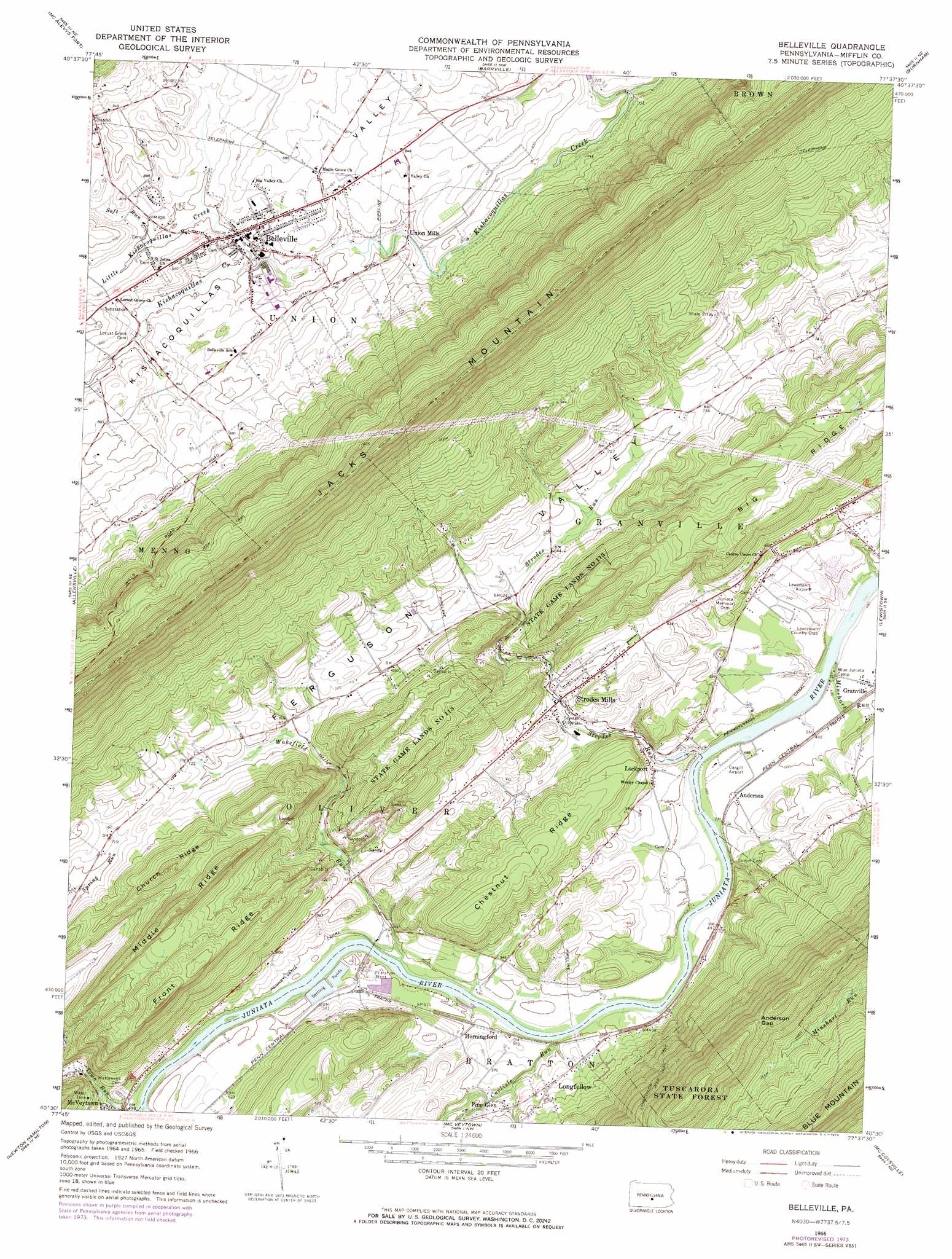
Belleville Topo Map Pennsylvania
To zoom in, hover over the map of Belleville
USGS Topo Quad 40077e6 - 1:24,000 scale
| Topo Map Name: | Belleville |
| USGS Topo Quad ID: | 40077e6 |
| Print Size: | ca. 21 1/4" wide x 27" high |
| Southeast Coordinates: | 40.5° N latitude / 77.625° W longitude |
| Map Center Coordinates: | 40.5625° N latitude / 77.6875° W longitude |
| U.S. State: | PA |
| Filename: | o40077e6.jpg |
| Download Map JPG Image: | Belleville topo map 1:24,000 scale |
| Map Type: | Topographic |
| Topo Series: | 7.5´ |
| Map Scale: | 1:24,000 |
| Source of Map Images: | United States Geological Survey (USGS) |
| Alternate Map Versions: |
Belleville PA 1966, updated 1968 Download PDF Buy paper map Belleville PA 1966, updated 1972 Download PDF Buy paper map Belleville PA 2010 Download PDF Buy paper map Belleville PA 2013 Download PDF Buy paper map Belleville PA 2016 Download PDF Buy paper map |
1:24,000 Topo Quads surrounding Belleville
Julian |
State College |
Centre Hall |
Spring Mills |
Coburn |
Pine Grove Mills |
Mcalevys Fort |
Barrville |
Burnham |
Alfarata |
Donation |
Allensville |
Belleville |
Lewistown |
Mifflintown |
Mount Union |
Newton Hamilton |
Mcveytown |
Mccoysville |
Spruce Hill |
Butler Knob |
Aughwick |
Blairs Mills |
Blain |
Andersonburg |
> Back to 40077e1 at 1:100,000 scale
> Back to 40076a1 at 1:250,000 scale
> Back to U.S. Topo Maps home
Belleville topo map: Gazetteer
Belleville: Airports
Bratton Airport elevation 249m 816′Cargill Airport elevation 151m 495′
Lewistown Airport elevation 155m 508′
Belleville: Basins
Ferguson Valley elevation 210m 688′Belleville: Canals
Pennsylvania Canal elevation 152m 498′Belleville: Dams
Miller Dam elevation 144m 472′Belleville: Gaps
Anderson Gap elevation 487m 1597′Belleville: Parks
State Game Lands Number 113 elevation 271m 889′Belleville: Populated Places
Anderson elevation 153m 501′Belleville elevation 243m 797′
Granville elevation 152m 498′
Horningford elevation 154m 505′
Lockport elevation 159m 521′
Longfellow elevation 170m 557′
Mechanicsville elevation 250m 820′
Pine Glen elevation 177m 580′
Strodes Mills elevation 171m 561′
Union Mills elevation 237m 777′
Belleville: Ridges
Chestnut Ridge elevation 246m 807′Church Ridge elevation 338m 1108′
Front Ridge elevation 341m 1118′
Middle Ridge elevation 367m 1204′
Belleville: Streams
Carlisle Run elevation 153m 501′Little Kishacoquillas Creek elevation 237m 777′
Minehart Run elevation 140m 459′
Soft Run elevation 243m 797′
Strodes Run elevation 134m 439′
Town Run elevation 141m 462′
Wakefield Run elevation 146m 479′
Belleville digital topo map on disk
Buy this Belleville topo map showing relief, roads, GPS coordinates and other geographical features, as a high-resolution digital map file on DVD:
Atlantic Coast (NY, NJ, PA, DE, MD, VA, NC)
Buy digital topo maps: Atlantic Coast (NY, NJ, PA, DE, MD, VA, NC)
 map DVD")