Alfarata Topo Map Pennsylvania
To zoom in, hover over the map of Alfarata
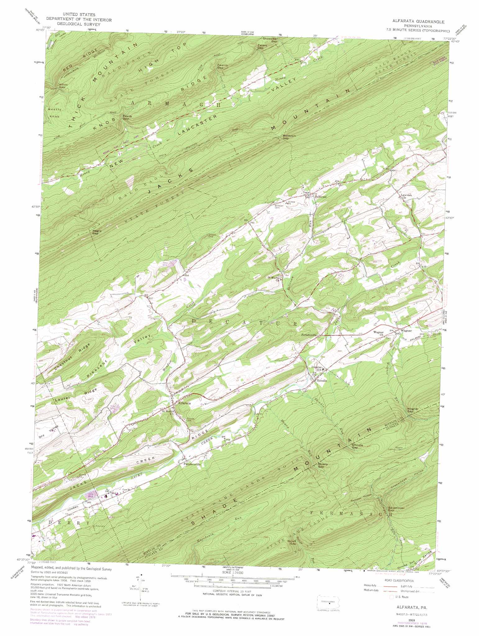
USGS Topo Quad 40077f4 - 1:24,000 scale
| Topo Map Name: | Alfarata |
| USGS Topo Quad ID: | 40077f4 |
| Print Size: | ca. 21 1/4" wide x 27" high |
| Southeast Coordinates: | 40.625° N latitude / 77.375° W longitude |
| Map Center Coordinates: | 40.6875° N latitude / 77.4375° W longitude |
| U.S. State: | PA |
| Filename: | o40077f4.jpg |
| Download Map JPG Image: | Alfarata topo map 1:24,000 scale |
| Map Type: | Topographic |
| Topo Series: | 7.5´ |
| Map Scale: | 1:24,000 |
| Source of Map Images: | United States Geological Survey (USGS) |
| Alternate Map Versions: |
Alfarata PA 1959, updated 1960 Download PDF Buy paper map Alfarata PA 1959, updated 1971 Download PDF Buy paper map Alfarata PA 1959, updated 1978 Download PDF Buy paper map Alfarata PA 1959, updated 1978 Download PDF Buy paper map Alfarata PA 1977, updated 1979 Download PDF Buy paper map Alfarata PA 2010 Download PDF Buy paper map Alfarata PA 2013 Download PDF Buy paper map Alfarata PA 2016 Download PDF Buy paper map |
1:24,000 Topo Quads surrounding Alfarata
Mingoville |
Madisonburg |
Millheim |
Woodward |
Hartleton |
Centre Hall |
Spring Mills |
Coburn |
Weikert |
Beavertown |
Barrville |
Burnham |
Alfarata |
Mcclure |
Beaver Springs |
Belleville |
Lewistown |
Mifflintown |
Mexico |
Millerstown |
Mcveytown |
Mccoysville |
Spruce Hill |
Ickesburg |
Newport |
> Back to 40077e1 at 1:100,000 scale
> Back to 40076a1 at 1:250,000 scale
> Back to U.S. Topo Maps home
Alfarata topo map: Gazetteer
Alfarata: Airports
Shangri La Airport elevation 230m 754′Alfarata: Basins
Slim Valley elevation 243m 797′Alfarata: Gaps
Aitkin Gap elevation 412m 1351′Belltown Gap elevation 498m 1633′
Kearns Gap elevation 363m 1190′
Mowry Gap elevation 373m 1223′
Negro Gap elevation 556m 1824′
Peters Gap elevation 395m 1295′
Reeds Gap elevation 355m 1164′
Shindle Gap elevation 409m 1341′
Spigelmyer Gap elevation 326m 1069′
Suloff Gap elevation 396m 1299′
Wagner Gap elevation 377m 1236′
Alfarata: Parks
Reeds Gap State Park elevation 250m 820′State Game Lands Number 107 elevation 401m 1315′
Alfarata: Populated Places
Alfarata elevation 180m 590′Belltown elevation 207m 679′
Decatur elevation 207m 679′
Paintersville elevation 175m 574′
Shindle elevation 182m 597′
Snook elevation 225m 738′
Soradoville elevation 191m 626′
Wagner elevation 204m 669′
Alfarata: Ridges
Chestnut Ridge elevation 327m 1072′Jacks Creek Ridge elevation 263m 862′
Laurel Ridge elevation 281m 921′
Red Ridge elevation 444m 1456′
Alfarata: Streams
Belltown Run elevation 181m 593′Meadow Creek elevation 167m 547′
Mowry Run elevation 173m 567′
Shindle Run elevation 176m 577′
Wagner Run elevation 195m 639′
Alfarata: Valleys
Copperhead Hollow elevation 352m 1154′Pleasant Valley elevation 209m 685′
Raccoon Hollow elevation 367m 1204′
Alfarata digital topo map on disk
Buy this Alfarata topo map showing relief, roads, GPS coordinates and other geographical features, as a high-resolution digital map file on DVD:
Atlantic Coast (NY, NJ, PA, DE, MD, VA, NC)
Buy digital topo maps: Atlantic Coast (NY, NJ, PA, DE, MD, VA, NC)
 map DVD")