Beavertown Topo Map Pennsylvania
To zoom in, hover over the map of Beavertown
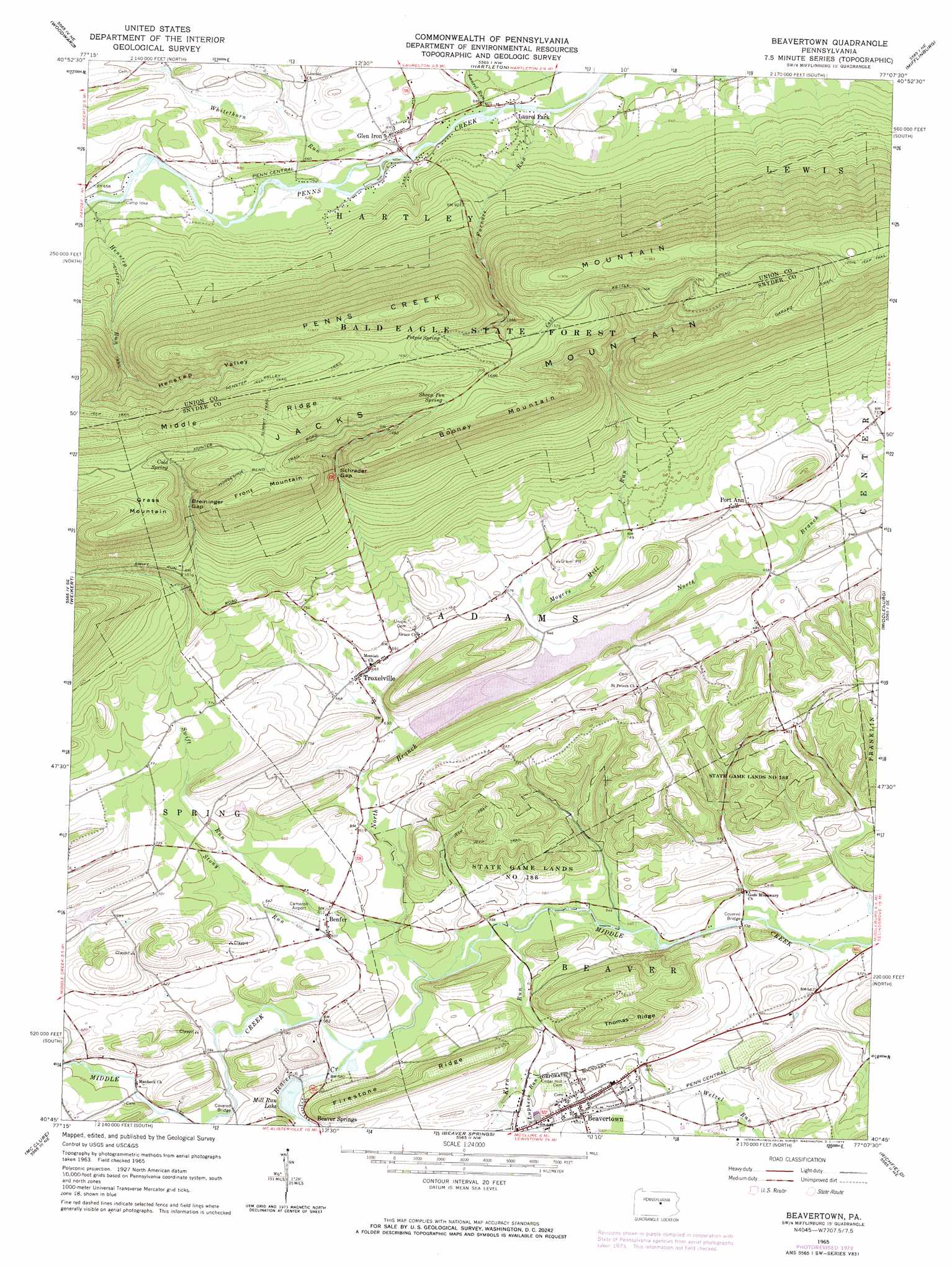
USGS Topo Quad 40077g2 - 1:24,000 scale
| Topo Map Name: | Beavertown |
| USGS Topo Quad ID: | 40077g2 |
| Print Size: | ca. 21 1/4" wide x 27" high |
| Southeast Coordinates: | 40.75° N latitude / 77.125° W longitude |
| Map Center Coordinates: | 40.8125° N latitude / 77.1875° W longitude |
| U.S. State: | PA |
| Filename: | o40077g2.jpg |
| Download Map JPG Image: | Beavertown topo map 1:24,000 scale |
| Map Type: | Topographic |
| Topo Series: | 7.5´ |
| Map Scale: | 1:24,000 |
| Source of Map Images: | United States Geological Survey (USGS) |
| Alternate Map Versions: |
Beavertown PA 1965, updated 1966 Download PDF Buy paper map Beavertown PA 1965, updated 1973 Download PDF Buy paper map Beavertown PA 1965, updated 1973 Download PDF Buy paper map Beavertown PA 2010 Download PDF Buy paper map Beavertown PA 2013 Download PDF Buy paper map Beavertown PA 2016 Download PDF Buy paper map |
1:24,000 Topo Quads surrounding Beavertown
Mill Hall |
Loganton |
Carroll |
Williamsport Se |
Allenwood |
Millheim |
Woodward |
Hartleton |
Mifflinburg |
Lewisburg |
Coburn |
Weikert |
Beavertown |
Middleburg |
Freeburg |
Alfarata |
Mcclure |
Beaver Springs |
Richfield |
Dalmatia |
Mifflintown |
Mexico |
Millerstown |
Reward |
Millersburg |
> Back to 40077e1 at 1:100,000 scale
> Back to 40076a1 at 1:250,000 scale
> Back to U.S. Topo Maps home
Beavertown topo map: Gazetteer
Beavertown: Airports
Beaver Springs Airport elevation 193m 633′Beavertown: Dams
Middle Creek Dam elevation 184m 603′Beavertown: Gaps
Breininger Gap elevation 398m 1305′Schrader Gap elevation 394m 1292′
Beavertown: Lakes
Mill Run Lake elevation 177m 580′Beavertown: Parks
State Game Lands Number 188 elevation 179m 587′Beavertown: Populated Places
Beavertown elevation 196m 643′Benfer elevation 185m 606′
Glen Iron elevation 186m 610′
Laurel Park elevation 180m 590′
Port Ann elevation 219m 718′
Troxelville elevation 200m 656′
Beavertown: Reservoirs
Walker Lake elevation 184m 603′Beavertown: Ridges
Firestone Ridge elevation 261m 856′Middle Ridge elevation 588m 1929′
Thomas Ridge elevation 304m 997′
Beavertown: Springs
Cold Spring elevation 456m 1496′Potpie Spring elevation 473m 1551′
Sheep Pen Spring elevation 502m 1646′
Beavertown: Streams
Beaver Creek elevation 173m 567′Furnace Run elevation 177m 580′
Henstep Run elevation 199m 652′
Kern Run elevation 165m 541′
Laurel Run elevation 181m 593′
Luphers Run elevation 179m 587′
Moyers Mill Run elevation 189m 620′
North Branch Middle Creek elevation 177m 580′
South Branch Middle Creek elevation 177m 580′
Stony Run elevation 168m 551′
Swift Run elevation 168m 551′
Wetzel Run elevation 176m 577′
Whitethorn Run elevation 182m 597′
Beavertown: Summits
Booney Mountain elevation 551m 1807′Front Mountain elevation 544m 1784′
Grass Mountain elevation 547m 1794′
Beavertown: Trails
Garard Trail elevation 558m 1830′Henstep Trail elevation 266m 872′
Horseshoe Bend Trail elevation 497m 1630′
Summit Trail elevation 526m 1725′
Beavertown: Valleys
Henstep Valley elevation 330m 1082′Beavertown digital topo map on disk
Buy this Beavertown topo map showing relief, roads, GPS coordinates and other geographical features, as a high-resolution digital map file on DVD:
Atlantic Coast (NY, NJ, PA, DE, MD, VA, NC)
Buy digital topo maps: Atlantic Coast (NY, NJ, PA, DE, MD, VA, NC)
 map DVD")