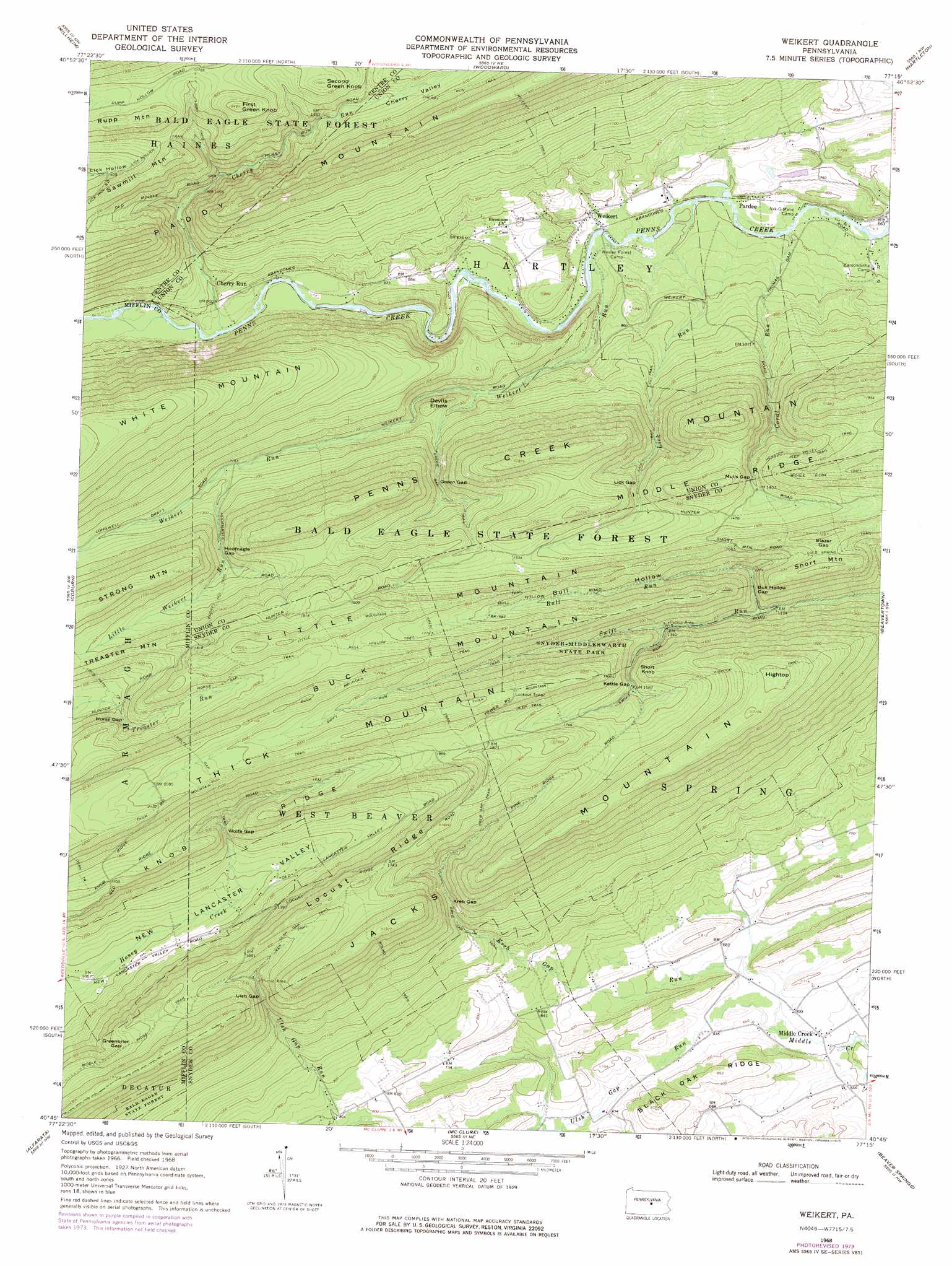
Weikert Topo Map Pennsylvania
To zoom in, hover over the map of Weikert
USGS Topo Quad 40077g3 - 1:24,000 scale
| Topo Map Name: | Weikert |
| USGS Topo Quad ID: | 40077g3 |
| Print Size: | ca. 21 1/4" wide x 27" high |
| Southeast Coordinates: | 40.75° N latitude / 77.25° W longitude |
| Map Center Coordinates: | 40.8125° N latitude / 77.3125° W longitude |
| U.S. State: | PA |
| Filename: | o40077g3.jpg |
| Download Map JPG Image: | Weikert topo map 1:24,000 scale |
| Map Type: | Topographic |
| Topo Series: | 7.5´ |
| Map Scale: | 1:24,000 |
| Source of Map Images: | United States Geological Survey (USGS) |
| Alternate Map Versions: |
Weikert PA 1968, updated 1971 Download PDF Buy paper map Weikert PA 1968, updated 1975 Download PDF Buy paper map Weikert PA 2010 Download PDF Buy paper map Weikert PA 2013 Download PDF Buy paper map Weikert PA 2016 Download PDF Buy paper map |
1:24,000 Topo Quads surrounding Weikert
Beech Creek |
Mill Hall |
Loganton |
Carroll |
Williamsport Se |
Madisonburg |
Millheim |
Woodward |
Hartleton |
Mifflinburg |
Spring Mills |
Coburn |
Weikert |
Beavertown |
Middleburg |
Burnham |
Alfarata |
Mcclure |
Beaver Springs |
Richfield |
Lewistown |
Mifflintown |
Mexico |
Millerstown |
Reward |
> Back to 40077e1 at 1:100,000 scale
> Back to 40076a1 at 1:250,000 scale
> Back to U.S. Topo Maps home
Weikert topo map: Gazetteer
Weikert: Areas
Snyder Middleswarth Natural Area elevation 405m 1328′Tall Timber Natural Area elevation 585m 1919′
White Mountain Wild Area elevation 544m 1784′
Weikert: Gaps
Blazer Gap elevation 490m 1607′Bull Hollow Gap elevation 375m 1230′
Green Gap elevation 365m 1197′
Greenbrier Gap elevation 443m 1453′
Hoofnagle Gap elevation 404m 1325′
Horse Gap elevation 475m 1558′
Kettle Gap elevation 490m 1607′
Kreb Gap elevation 394m 1292′
Lick Gap elevation 401m 1315′
Mulls Gap elevation 437m 1433′
Ulsh Gap elevation 427m 1400′
Wolfe Gap elevation 419m 1374′
Weikert: Parks
Snyder-Middleswarth State Park elevation 545m 1788′Weikert: Populated Places
Camp Hironimus elevation 244m 800′Cherry Run elevation 281m 921′
Middle Creek elevation 187m 613′
Pardee elevation 212m 695′
Weikert elevation 225m 738′
Weikert: Ridges
Locust Ridge elevation 556m 1824′Weikert: Streams
Bull Run elevation 352m 1154′Cherry Run elevation 255m 836′
Coral Run elevation 208m 682′
Kreb Gap Run elevation 187m 613′
Lick Run elevation 213m 698′
Little Weikert Run elevation 352m 1154′
Ulsh Gap Run elevation 187m 613′
Weikert Run elevation 223m 731′
Weikert: Summits
Buck Mountain elevation 628m 2060′Devils Elbow elevation 350m 1148′
First Green Knob elevation 593m 1945′
Hightop elevation 638m 2093′
Little Mountain elevation 619m 2030′
Penns Creek Mountain elevation 567m 1860′
Rupp Mountain elevation 571m 1873′
Second Green Knob elevation 538m 1765′
Short Knob elevation 570m 1870′
Short Mountain elevation 517m 1696′
Weikert: Trails
Booney Hollow Trail elevation 436m 1430′Buck Mountain Trail elevation 625m 2050′
Bull Hollow Trail elevation 549m 1801′
Cold Spring Trail elevation 480m 1574′
Green Gap Trail elevation 364m 1194′
Henstep Valley Trail elevation 461m 1512′
Hightop Trail elevation 618m 2027′
Horse Gap Trail elevation 550m 1804′
Kreb Gap Trail elevation 537m 1761′
Libby Trail elevation 508m 1666′
Libby Trail elevation 477m 1564′
Lick Gap Trail elevation 310m 1017′
Lick Hollow Trail elevation 490m 1607′
Little Mountain Trail elevation 559m 1833′
Long Path Trail elevation 446m 1463′
Middle Ridge Trail elevation 544m 1784′
Middle Ridge Trail elevation 525m 1722′
Round Trail elevation 384m 1259′
Swift Run Trail elevation 541m 1774′
Thick Mountain Trail elevation 639m 2096′
Ulsh Gap Trail elevation 512m 1679′
Wolfe Gap Trail elevation 552m 1811′
Weikert: Valleys
Bull Hollow elevation 395m 1295′Cherry Valley elevation 256m 839′
Weikert digital topo map on disk
Buy this Weikert topo map showing relief, roads, GPS coordinates and other geographical features, as a high-resolution digital map file on DVD:
Atlantic Coast (NY, NJ, PA, DE, MD, VA, NC)
Buy digital topo maps: Atlantic Coast (NY, NJ, PA, DE, MD, VA, NC)
 map DVD")