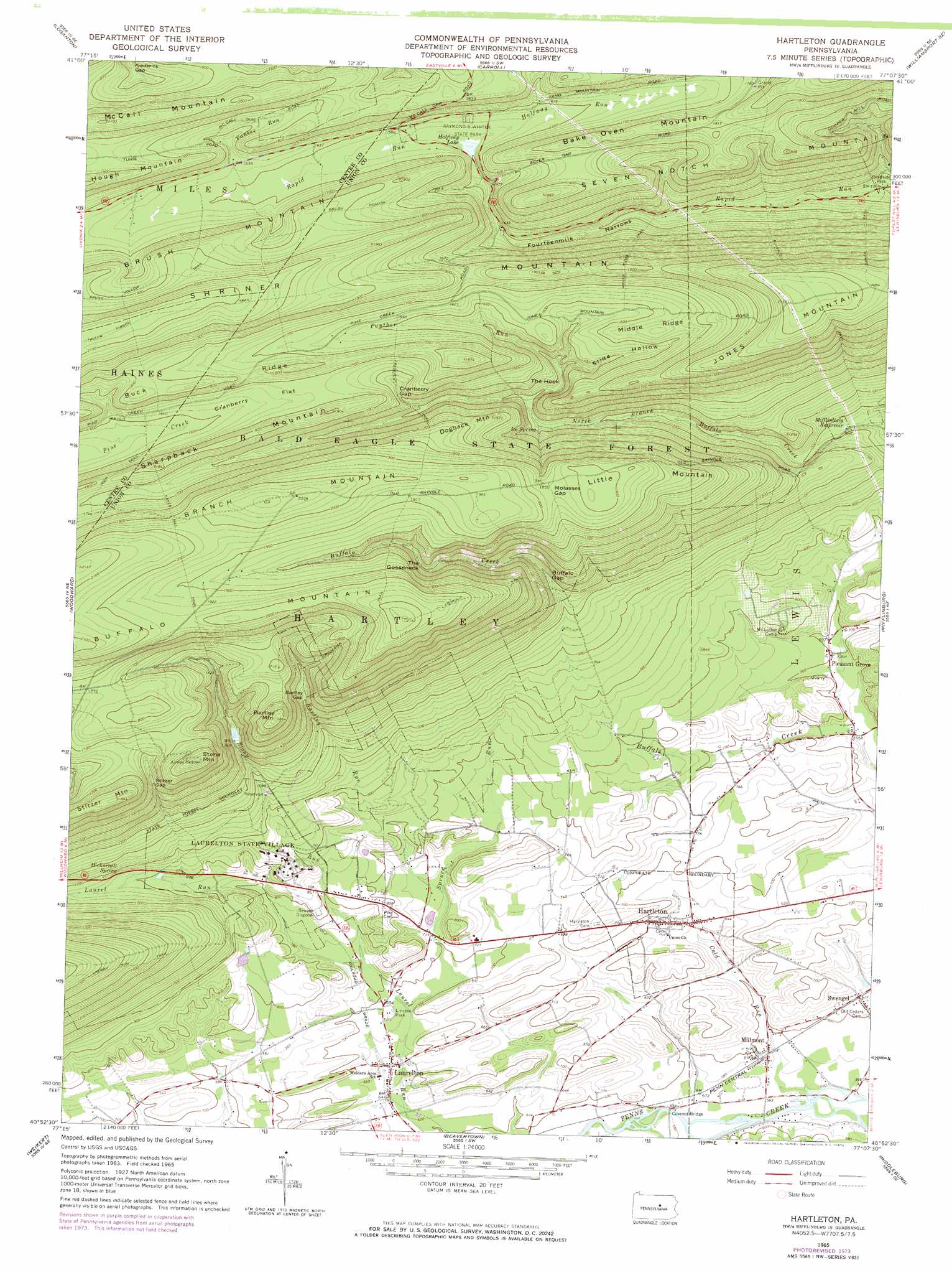
Hartleton Topo Map Pennsylvania
To zoom in, hover over the map of Hartleton
USGS Topo Quad 40077h2 - 1:24,000 scale
| Topo Map Name: | Hartleton |
| USGS Topo Quad ID: | 40077h2 |
| Print Size: | ca. 21 1/4" wide x 27" high |
| Southeast Coordinates: | 40.875° N latitude / 77.125° W longitude |
| Map Center Coordinates: | 40.9375° N latitude / 77.1875° W longitude |
| U.S. State: | PA |
| Filename: | o40077h2.jpg |
| Download Map JPG Image: | Hartleton topo map 1:24,000 scale |
| Map Type: | Topographic |
| Topo Series: | 7.5´ |
| Map Scale: | 1:24,000 |
| Source of Map Images: | United States Geological Survey (USGS) |
| Alternate Map Versions: |
Hartleton PA 1965, updated 1967 Download PDF Buy paper map Hartleton PA 1965, updated 1973 Download PDF Buy paper map Hartleton PA 2010 Download PDF Buy paper map Hartleton PA 2013 Download PDF Buy paper map Hartleton PA 2016 Download PDF Buy paper map |
1:24,000 Topo Quads surrounding Hartleton
Lock Haven |
Jersey Shore |
Linden |
Williamsport |
Montoursville South |
Mill Hall |
Loganton |
Carroll |
Williamsport Se |
Allenwood |
Millheim |
Woodward |
Hartleton |
Mifflinburg |
Lewisburg |
Coburn |
Weikert |
Beavertown |
Middleburg |
Freeburg |
Alfarata |
Mcclure |
Beaver Springs |
Richfield |
Dalmatia |
> Back to 40077e1 at 1:100,000 scale
> Back to 40076a1 at 1:250,000 scale
> Back to U.S. Topo Maps home
Hartleton topo map: Gazetteer
Hartleton: Bends
The Gooseneck elevation 463m 1519′The Hook elevation 441m 1446′
Hartleton: Dams
Halfway Dam elevation 457m 1499′Stony Run Dam elevation 392m 1286′
Hartleton: Flats
Cranberry Flat elevation 513m 1683′Hartleton: Gaps
Bartley Gap elevation 420m 1377′Buffalo Gap elevation 363m 1190′
Cranberry Gap elevation 470m 1541′
Fourteenmile Narrows elevation 409m 1341′
Frederick Gap elevation 500m 1640′
Molasses Gap elevation 568m 1863′
Rapid Run Gap elevation 442m 1450′
Stitzer Gap elevation 458m 1502′
Hartleton: Lakes
Halfway Lake elevation 460m 1509′Hartleton: Parks
Lincoln Park elevation 209m 685′McCall Field elevation 550m 1804′
Raymond B Winter State Park elevation 477m 1564′
Rock Oak Park (historical) elevation 206m 675′
Hartleton: Populated Places
Hartleton elevation 199m 652′Laurelton elevation 199m 652′
Millmont elevation 179m 587′
Pleasant Grove elevation 214m 702′
Swengel elevation 187m 613′
Hartleton: Reservoirs
Mifflinburg Reservoir elevation 293m 961′Hartleton: Ridges
Buck Ridge elevation 569m 1866′Middle Ridge elevation 507m 1663′
Hartleton: Springs
Boiling Spring elevation 514m 1686′Hickernell Spring elevation 299m 980′
Ice Spring elevation 383m 1256′
The Little Bubbler elevation 463m 1519′
Hartleton: Streams
Bartley Run elevation 228m 748′Cold Run elevation 170m 557′
Halfway Run elevation 469m 1538′
Panther Run elevation 393m 1289′
Spruce Run elevation 216m 708′
Stony Run elevation 220m 721′
Yankee Run elevation 488m 1601′
Hartleton: Summits
Bake Oven Mountain elevation 563m 1847′Bartley Mountain elevation 566m 1856′
Branch Mountain elevation 653m 2142′
Dogback Mountain elevation 501m 1643′
Jones Mountain elevation 659m 2162′
Little Mountain elevation 584m 1916′
McCall Mountain elevation 640m 2099′
Seven Notch Mountain elevation 571m 1873′
Stitzer Mountain elevation 561m 1840′
Stone Mountain elevation 576m 1889′
Hartleton: Trails
Baker Path elevation 466m 1528′Brocher Path elevation 554m 1817′
Buffalo Path elevation 646m 2119′
Douty Mill Trail elevation 325m 1066′
Dug Trail elevation 508m 1666′
Frederick Trail elevation 564m 1850′
Fredricks Trail elevation 527m 1729′
Hayes Mill Trail elevation 592m 1942′
Lookout Trail elevation 589m 1932′
Middle Ridge Trail elevation 508m 1666′
Molasses Gap Trail elevation 539m 1768′
Oley Camp Trail elevation 504m 1653′
Park Bake Oven Trail elevation 552m 1811′
Yankee Run Trail elevation 581m 1906′
Hartleton: Valleys
Slide Hollow elevation 426m 1397′Hartleton digital topo map on disk
Buy this Hartleton topo map showing relief, roads, GPS coordinates and other geographical features, as a high-resolution digital map file on DVD:
Atlantic Coast (NY, NJ, PA, DE, MD, VA, NC)
Buy digital topo maps: Atlantic Coast (NY, NJ, PA, DE, MD, VA, NC)
 map DVD")