Bellefonte Topo Map Pennsylvania
To zoom in, hover over the map of Bellefonte
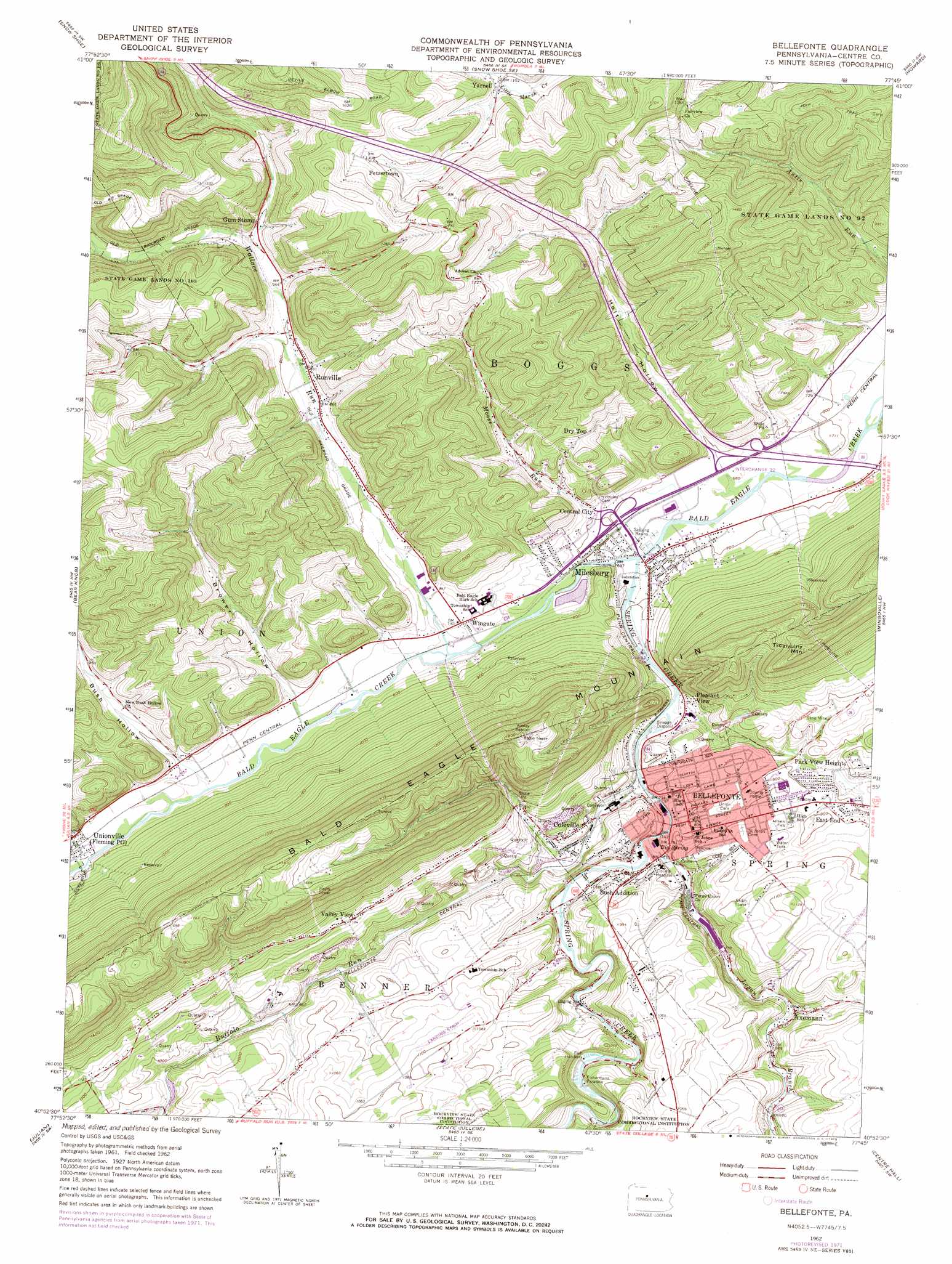
USGS Topo Quad 40077h7 - 1:24,000 scale
| Topo Map Name: | Bellefonte |
| USGS Topo Quad ID: | 40077h7 |
| Print Size: | ca. 21 1/4" wide x 27" high |
| Southeast Coordinates: | 40.875° N latitude / 77.75° W longitude |
| Map Center Coordinates: | 40.9375° N latitude / 77.8125° W longitude |
| U.S. State: | PA |
| Filename: | o40077h7.jpg |
| Download Map JPG Image: | Bellefonte topo map 1:24,000 scale |
| Map Type: | Topographic |
| Topo Series: | 7.5´ |
| Map Scale: | 1:24,000 |
| Source of Map Images: | United States Geological Survey (USGS) |
| Alternate Map Versions: |
Bellefonte PA 1962, updated 1964 Download PDF Buy paper map Bellefonte PA 1962, updated 1973 Download PDF Buy paper map Bellefonte PA 1977, updated 1979 Download PDF Buy paper map Bellefonte PA 1998, updated 1999 Download PDF Buy paper map Bellefonte PA 2010 Download PDF Buy paper map Bellefonte PA 2013 Download PDF Buy paper map Bellefonte PA 2016 Download PDF Buy paper map |
1:24,000 Topo Quads surrounding Bellefonte
Pottersdale |
Snow Shoe Nw |
Snow Shoe Ne |
Howard Nw |
Farrandsville |
Karthaus |
Snow Shoe |
Snow Shoe Se |
Howard |
Beech Creek |
Black Moshannon |
Bear Knob |
Bellefonte |
Mingoville |
Madisonburg |
Port Matilda |
Julian |
State College |
Centre Hall |
Spring Mills |
Franklinville |
Pine Grove Mills |
Mcalevys Fort |
Barrville |
Burnham |
> Back to 40077e1 at 1:100,000 scale
> Back to 40076a1 at 1:250,000 scale
> Back to U.S. Topo Maps home
Bellefonte topo map: Gazetteer
Bellefonte: Airports
Bellefonte Skypark elevation 328m 1076′Bellefonte: Gaps
Spring Creek Gap elevation 216m 708′Bellefonte: Parks
State Game Lands Number 92 elevation 328m 1076′Bellefonte: Populated Places
Axemann elevation 264m 866′Bellefonte elevation 243m 797′
Big Spring elevation 230m 754′
Bush Addition elevation 248m 813′
Central City elevation 247m 810′
Coleville elevation 258m 846′
Dry Top elevation 302m 990′
East End elevation 284m 931′
Fetzertown elevation 397m 1302′
Fishermans Paradise elevation 270m 885′
Gum Stump elevation 305m 1000′
Milesburg elevation 212m 695′
Park View Heights elevation 268m 879′
Pleasant View elevation 226m 741′
Runville elevation 267m 875′
Stevens elevation 258m 846′
Valley View elevation 329m 1079′
Wingate elevation 217m 711′
Yarnell elevation 342m 1122′
Bellefonte: Post Offices
Runville Post Office (historical) elevation 267m 875′Bellefonte: Springs
Axemann Spring elevation 266m 872′Forked Spring elevation 263m 862′
Kelley Spring elevation 238m 780′
Bellefonte: Streams
Brower Hollow Run elevation 218m 715′Buffalo Run elevation 228m 748′
Bush Hollow Run elevation 221m 725′
Dewitt Run elevation 230m 754′
Holt Run elevation 215m 705′
Logan Branch elevation 227m 744′
Moose Run elevation 224m 734′
Spring Creek elevation 209m 685′
Wallace Run elevation 220m 721′
Bellefonte: Summits
Trcziyulny Mountain elevation 504m 1653′Bellefonte: Valleys
Brower Hollow elevation 232m 761′Bush Hollow elevation 234m 767′
Holt Hollow elevation 227m 744′
Bellefonte digital topo map on disk
Buy this Bellefonte topo map showing relief, roads, GPS coordinates and other geographical features, as a high-resolution digital map file on DVD:
Atlantic Coast (NY, NJ, PA, DE, MD, VA, NC)
Buy digital topo maps: Atlantic Coast (NY, NJ, PA, DE, MD, VA, NC)
 map DVD")