Stoystown Topo Map Pennsylvania
To zoom in, hover over the map of Stoystown
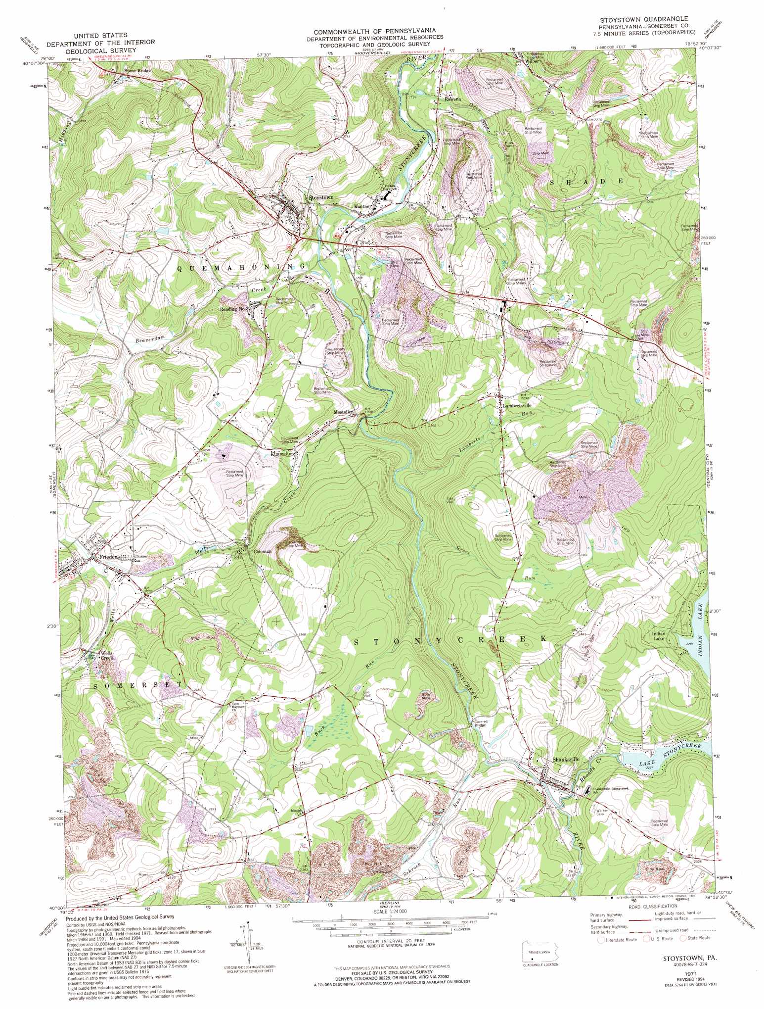
USGS Topo Quad 40078a8 - 1:24,000 scale
| Topo Map Name: | Stoystown |
| USGS Topo Quad ID: | 40078a8 |
| Print Size: | ca. 21 1/4" wide x 27" high |
| Southeast Coordinates: | 40° N latitude / 78.875° W longitude |
| Map Center Coordinates: | 40.0625° N latitude / 78.9375° W longitude |
| U.S. State: | PA |
| Filename: | o40078a8.jpg |
| Download Map JPG Image: | Stoystown topo map 1:24,000 scale |
| Map Type: | Topographic |
| Topo Series: | 7.5´ |
| Map Scale: | 1:24,000 |
| Source of Map Images: | United States Geological Survey (USGS) |
| Alternate Map Versions: |
Stoystown PA 1971, updated 1973 Download PDF Buy paper map Stoystown PA 1971, updated 1982 Download PDF Buy paper map Stoystown PA 1971, updated 1990 Download PDF Buy paper map Stoystown PA 1971, updated 1994 Download PDF Buy paper map Stoystown PA 1977, updated 1979 Download PDF Buy paper map Stoystown PA 1994, updated 1999 Download PDF Buy paper map Stoystown PA 1994, updated 2000 Download PDF Buy paper map Stoystown PA 2010 Download PDF Buy paper map Stoystown PA 2013 Download PDF Buy paper map Stoystown PA 2016 Download PDF Buy paper map |
1:24,000 Topo Quads surrounding Stoystown
Wilpen |
Rachelwood |
Johnstown |
Geistown |
Beaverdale |
Ligonier |
Boswell |
Hooversville |
Windber |
Ogletown |
Bakersville |
Somerset |
Stoystown |
Central City |
Schellsburg |
Rockwood |
Murdock |
Berlin |
New Baltimore |
Buffalo Mills |
Markleton |
Meyersdale |
Wittenberg |
Fairhope |
Hyndman |
> Back to 40078a1 at 1:100,000 scale
> Back to 40078a1 at 1:250,000 scale
> Back to U.S. Topo Maps home
Stoystown topo map: Gazetteer
Stoystown: Dams
Cowens Gap Dam elevation 702m 2303′Lake Stonycreek Dam elevation 691m 2267′
Stoystown: Parks
Flight 93 National Memorial elevation 723m 2372′Stoystown: Populated Places
Coleman elevation 610m 2001′Friedens elevation 644m 2112′
Kantner elevation 530m 1738′
Kimmelton elevation 613m 2011′
Lambertsville elevation 684m 2244′
Mostoller elevation 585m 1919′
Reading Number Three elevation 550m 1804′
Rowena elevation 544m 1784′
Shanksville elevation 680m 2230′
Stoystown elevation 559m 1833′
Wells Creek elevation 627m 2057′
Wilbur elevation 601m 1971′
Stoystown: Post Offices
Shanksville Post Office (historical) elevation 680m 2230′Stoystown Post Office (historical) elevation 559m 1833′
Stoystown: Reservoirs
Lake Stonycreek elevation 679m 2227′Stoystown: Streams
Beaverdam Creek elevation 534m 1751′Buck Run elevation 631m 2070′
Grove Run elevation 613m 2011′
Lamberts Run elevation 599m 1965′
Oven Run elevation 518m 1699′
Rhoads Creek elevation 670m 2198′
Schrock Run elevation 670m 2198′
Wells Creek elevation 578m 1896′
Stoystown: Valleys
Glades Valley elevation 675m 2214′Stoystown digital topo map on disk
Buy this Stoystown topo map showing relief, roads, GPS coordinates and other geographical features, as a high-resolution digital map file on DVD:
 map DVD")