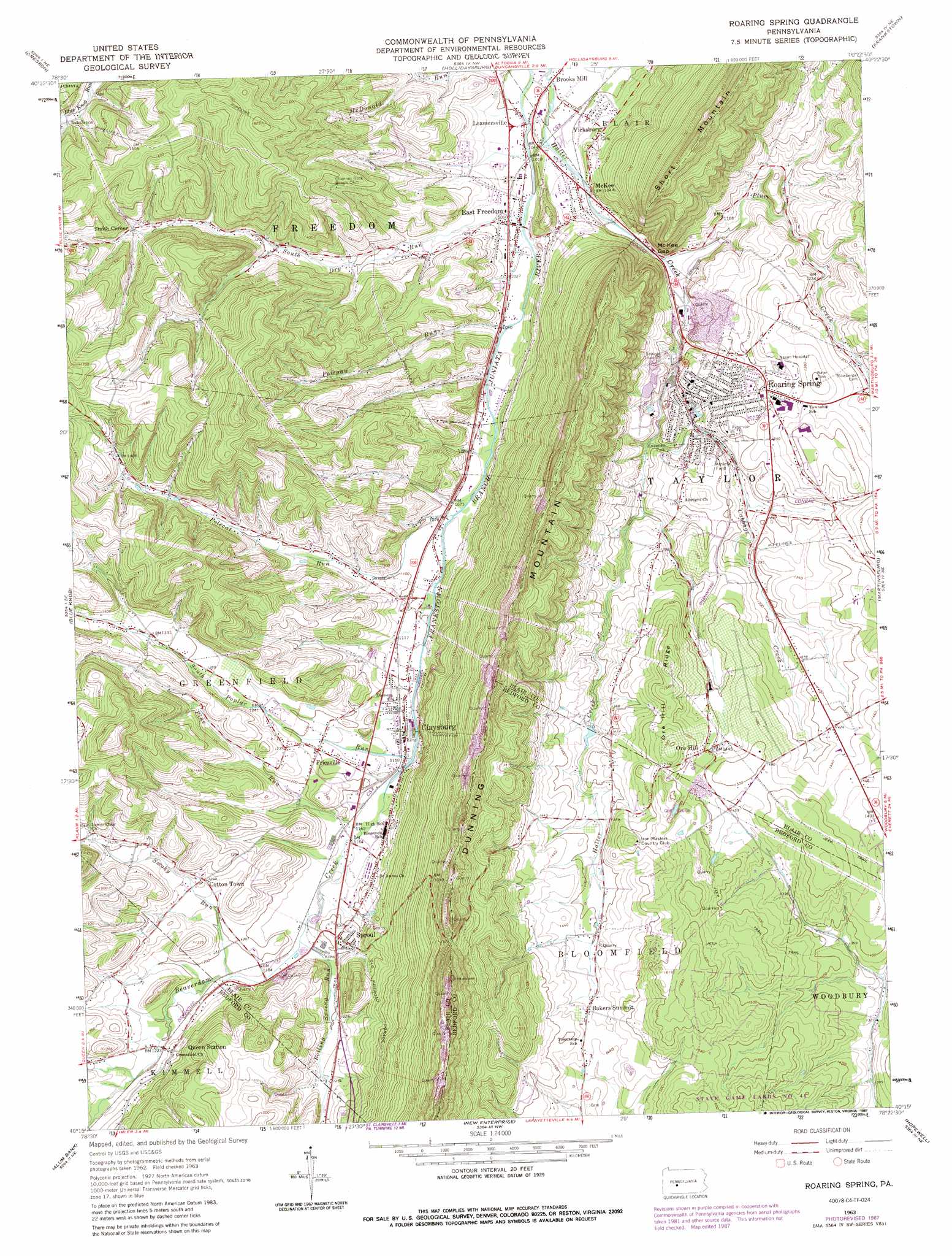
Roaring Spring Topo Map Pennsylvania
To zoom in, hover over the map of Roaring Spring
USGS Topo Quad 40078c4 - 1:24,000 scale
| Topo Map Name: | Roaring Spring |
| USGS Topo Quad ID: | 40078c4 |
| Print Size: | ca. 21 1/4" wide x 27" high |
| Southeast Coordinates: | 40.25° N latitude / 78.375° W longitude |
| Map Center Coordinates: | 40.3125° N latitude / 78.4375° W longitude |
| U.S. State: | PA |
| Filename: | o40078c4.jpg |
| Download Map JPG Image: | Roaring Spring topo map 1:24,000 scale |
| Map Type: | Topographic |
| Topo Series: | 7.5´ |
| Map Scale: | 1:24,000 |
| Source of Map Images: | United States Geological Survey (USGS) |
| Alternate Map Versions: |
Roaring Spring PA 1963, updated 1965 Download PDF Buy paper map Roaring Spring PA 1963, updated 1973 Download PDF Buy paper map Roaring Spring PA 1963, updated 1987 Download PDF Buy paper map Roaring Spring PA 1963, updated 1987 Download PDF Buy paper map Roaring Spring PA 2010 Download PDF Buy paper map Roaring Spring PA 2013 Download PDF Buy paper map Roaring Spring PA 2016 Download PDF Buy paper map |
1:24,000 Topo Quads surrounding Roaring Spring
Carrolltown |
Ashville |
Altoona |
Bellwood |
Spruce Creek |
Ebensburg |
Cresson |
Hollidaysburg |
Frankstown |
Williamsburg |
Beaverdale |
Blue Knob |
Roaring Spring |
Martinsburg |
Entriken |
Ogletown |
Alum Bank |
New Enterprise |
Hopewell |
Saxton |
Schellsburg |
Bedford |
Everett West |
Everett East |
Wells Tannery |
> Back to 40078a1 at 1:100,000 scale
> Back to 40078a1 at 1:250,000 scale
> Back to U.S. Topo Maps home
Roaring Spring topo map: Gazetteer
Roaring Spring: Dams
Steam Pump Dam elevation 402m 1318′Roaring Spring: Gaps
McKee Gap elevation 327m 1072′Roaring Spring: Parks
Shawnee Park elevation 379m 1243′Roaring Spring: Populated Places
Bakers Summit elevation 440m 1443′Brooks Mill elevation 299m 980′
Claysburg elevation 349m 1145′
Cotton Town elevation 383m 1256′
East Freedom elevation 308m 1010′
Friesville elevation 364m 1194′
Leamersville elevation 302m 990′
McKee elevation 319m 1046′
Ore Hill elevation 440m 1443′
Roaring Spring elevation 398m 1305′
Rodman elevation 366m 1200′
Smith Corner elevation 411m 1348′
Sproul elevation 374m 1227′
Vicksburg elevation 327m 1072′
Roaring Spring: Ridges
Ore Hill Ridge elevation 469m 1538′Roaring Spring: Springs
Roaring Spring elevation 367m 1204′Weynant Spring elevation 356m 1167′
Roaring Spring: Streams
Beaverdam Creek elevation 345m 1131′Boiling Spring Run elevation 355m 1164′
Cabbage Creek elevation 353m 1158′
Pawpaw Run elevation 312m 1023′
Pine Run elevation 352m 1154′
Plum Creek elevation 337m 1105′
Polecat Run elevation 325m 1066′
Smoky Run elevation 358m 1174′
South Dry Run elevation 306m 1003′
South Poplar Run elevation 345m 1131′
Roaring Spring digital topo map on disk
Buy this Roaring Spring topo map showing relief, roads, GPS coordinates and other geographical features, as a high-resolution digital map file on DVD:
 map DVD")