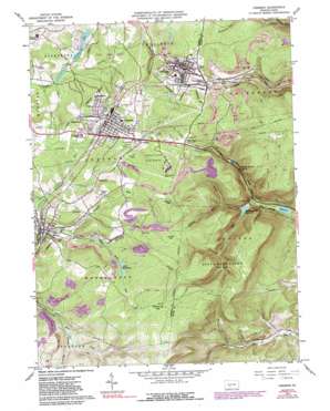
Cresson Topo Map Pennsylvania
To zoom in, hover over the map of Cresson
USGS Topo Quad 40078d5 - 1:24,000 scale
| Topo Map Name: | Cresson |
| USGS Topo Quad ID: | 40078d5 |
| Print Size: | ca. 21 1/4" wide x 27" high |
| Southeast Coordinates: | 40.375° N latitude / 78.5° W longitude |
| Map Center Coordinates: | 40.4375° N latitude / 78.5625° W longitude |
| U.S. State: | PA |
| Filename: | o40078d5.jpg |
| Download Map JPG Image: | Cresson topo map 1:24,000 scale |
| Map Type: | Topographic |
| Topo Series: | 7.5´ |
| Map Scale: | 1:24,000 |
| Source of Map Images: | United States Geological Survey (USGS) |
| Alternate Map Versions: |
Cresson PA 1963, updated 1965 Download PDF Buy paper map Cresson PA 1963, updated 1971 Download PDF Buy paper map Cresson PA 1963, updated 1973 Download PDF Buy paper map Cresson PA 1963, updated 1982 Download PDF Buy paper map Cresson PA 1963, updated 1989 Download PDF Buy paper map Cresson PA 1963, updated 1989 Download PDF Buy paper map Cresson PA 2010 Download PDF Buy paper map Cresson PA 2013 Download PDF Buy paper map Cresson PA 2016 Download PDF Buy paper map |
1:24,000 Topo Quads surrounding Cresson
> Back to 40078a1 at 1:100,000 scale
> Back to 40078a1 at 1:250,000 scale
> Back to U.S. Topo Maps home
Cresson topo map: Gazetteer
Cresson: Dams
Bear Rock Dam One elevation 702m 2303′Bear Rock Dam Two elevation 733m 2404′
Blair Gap Dam elevation 549m 1801′
Cresson Dam elevation 544m 1784′
Hollidaysburg Dam elevation 480m 1574′
Plain Nine Dam elevation 427m 1400′
Cresson: Gaps
Adams Gap elevation 754m 2473′Big Spring Gap elevation 796m 2611′
Blair Gap elevation 721m 2365′
Laurel Gap elevation 770m 2526′
Sugar Run Gap elevation 644m 2112′
The Muleshoe elevation 597m 1958′
Cresson: Parks
Admiral Perry Park elevation 625m 2050′State Game Lands Number 198 elevation 592m 1942′
State Game Lands Number 279 elevation 630m 2066′
Cresson: Populated Places
Cresson elevation 615m 2017′Dysertown elevation 644m 2112′
Gallitzin elevation 665m 2181′
Hoguetown elevation 622m 2040′
Lilly elevation 583m 1912′
Lucket elevation 634m 2080′
Pine Grove elevation 606m 1988′
Sankertown elevation 630m 2066′
Summit elevation 708m 2322′
Tunnelhill elevation 707m 2319′
Cresson: Reservoirs
Blair Gap Reservoir elevation 549m 1801′Cresson Lake elevation 543m 1781′
Hollidaysburg Reservoir elevation 470m 1541′
Lilly Number Two Reservoir elevation 733m 2404′
Lilly Reservoirs elevation 710m 2329′
Lily Number One Reservoir elevation 702m 2303′
Plain Nine Reservoir elevation 427m 1400′
Cresson: Springs
Gallitzin Spring elevation 525m 1722′Cresson: Streams
Adams Run elevation 489m 1604′Bear Rock Run elevation 574m 1883′
Blair Run elevation 455m 1492′
Burgoon Run elevation 604m 1981′
Redlick Run elevation 547m 1794′
Cresson: Valleys
Christie Hollow elevation 666m 2185′Dividing Hollow elevation 649m 2129′
Cresson digital topo map on disk
Buy this Cresson topo map showing relief, roads, GPS coordinates and other geographical features, as a high-resolution digital map file on DVD:


