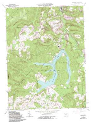
Coalport Topo Map Pennsylvania
To zoom in, hover over the map of Coalport
USGS Topo Quad 40078f5 - 1:24,000 scale
| Topo Map Name: | Coalport |
| USGS Topo Quad ID: | 40078f5 |
| Print Size: | ca. 21 1/4" wide x 27" high |
| Southeast Coordinates: | 40.625° N latitude / 78.5° W longitude |
| Map Center Coordinates: | 40.6875° N latitude / 78.5625° W longitude |
| U.S. State: | PA |
| Filename: | o40078f5.jpg |
| Download Map JPG Image: | Coalport topo map 1:24,000 scale |
| Map Type: | Topographic |
| Topo Series: | 7.5´ |
| Map Scale: | 1:24,000 |
| Source of Map Images: | United States Geological Survey (USGS) |
| Alternate Map Versions: |
Coalport PA 1961, updated 1963 Download PDF Buy paper map Coalport PA 1961, updated 1969 Download PDF Buy paper map Coalport PA 1961, updated 1973 Download PDF Buy paper map Coalport PA 1961, updated 1982 Download PDF Buy paper map Coalport PA 1961, updated 1982 Download PDF Buy paper map Coalport PA 1961, updated 1986 Download PDF Buy paper map Coalport PA 1961, updated 1994 Download PDF Buy paper map Coalport PA 1998, updated 1999 Download PDF Buy paper map Coalport PA 2010 Download PDF Buy paper map Coalport PA 2013 Download PDF Buy paper map Coalport PA 2016 Download PDF Buy paper map |
1:24,000 Topo Quads surrounding Coalport
> Back to 40078e1 at 1:100,000 scale
> Back to 40078a1 at 1:250,000 scale
> Back to U.S. Topo Maps home
Coalport topo map: Gazetteer
Coalport: Bridges
Irvona Bridge elevation 434m 1423′Coalport: Dams
Glendale Dam elevation 435m 1427′Coalport: Parks
Prince Gallitzin State Park elevation 469m 1538′State Game Lands Number 108 elevation 441m 1446′
State Game Lands Number 120 elevation 602m 1975′
Coalport: Populated Places
Beaver Valley elevation 451m 1479′Coalport elevation 429m 1407′
Fiske elevation 440m 1443′
Flinton elevation 448m 1469′
Heverly elevation 458m 1502′
Longs Crossroad elevation 481m 1578′
Lyleville elevation 442m 1450′
Nagles Crossroad elevation 482m 1581′
Coalport: Reservoirs
Glendale Lake elevation 435m 1427′Coalport: Ridges
Snake Ridge elevation 500m 1640′Coalport: Streams
Beaverdam Run elevation 423m 1387′Blain Run elevation 423m 1387′
Burgoon Run elevation 438m 1437′
Dutch Run elevation 425m 1394′
Kibler Run elevation 430m 1410′
Killbuck Run elevation 436m 1430′
Little Killbuck Run elevation 443m 1453′
Slate Lick Run elevation 435m 1427′
Turner Run elevation 422m 1384′
Wyerough Run elevation 435m 1427′
Coalport digital topo map on disk
Buy this Coalport topo map showing relief, roads, GPS coordinates and other geographical features, as a high-resolution digital map file on DVD:


