Houtzdale Topo Map Pennsylvania
To zoom in, hover over the map of Houtzdale
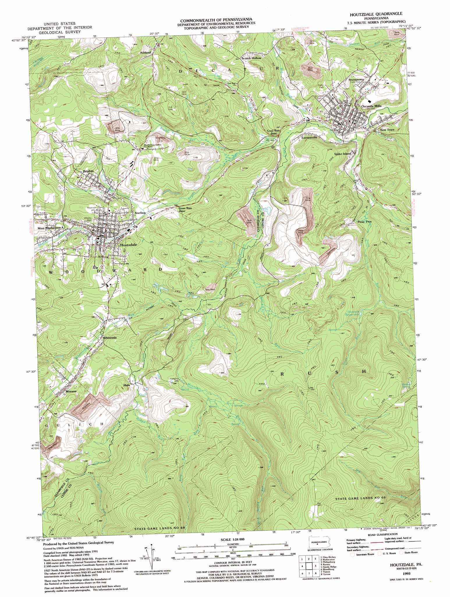
USGS Topo Quad 40078g3 - 1:24,000 scale
| Topo Map Name: | Houtzdale |
| USGS Topo Quad ID: | 40078g3 |
| Print Size: | ca. 21 1/4" wide x 27" high |
| Southeast Coordinates: | 40.75° N latitude / 78.25° W longitude |
| Map Center Coordinates: | 40.8125° N latitude / 78.3125° W longitude |
| U.S. State: | PA |
| Filename: | o40078g3.jpg |
| Download Map JPG Image: | Houtzdale topo map 1:24,000 scale |
| Map Type: | Topographic |
| Topo Series: | 7.5´ |
| Map Scale: | 1:24,000 |
| Source of Map Images: | United States Geological Survey (USGS) |
| Alternate Map Versions: |
Houtzdale PA 1944, updated 1956 Download PDF Buy paper map Houtzdale PA 1944, updated 1967 Download PDF Buy paper map Houtzdale PA 1944, updated 1970 Download PDF Buy paper map Houtzdale PA 1944, updated 1982 Download PDF Buy paper map Houtzdale PA 1944, updated 1988 Download PDF Buy paper map Houtzdale PA 1993, updated 1994 Download PDF Buy paper map Houtzdale PA 1993, updated 1994 Download PDF Buy paper map Houtzdale PA 2010 Download PDF Buy paper map Houtzdale PA 2013 Download PDF Buy paper map Houtzdale PA 2016 Download PDF Buy paper map |
1:24,000 Topo Quads surrounding Houtzdale
Elliott Park |
Clearfield |
Lecontes Mills |
Frenchville |
Karthaus |
Curwensville |
Glen Richey |
Wallaceton |
Philipsburg |
Black Moshannon |
Irvona |
Ramey |
Houtzdale |
Sandy Ridge |
Port Matilda |
Coalport |
Blandburg |
Tipton |
Tyrone |
Franklinville |
Ashville |
Altoona |
Bellwood |
Spruce Creek |
Alexandria |
> Back to 40078e1 at 1:100,000 scale
> Back to 40078a1 at 1:250,000 scale
> Back to U.S. Topo Maps home
Houtzdale topo map: Gazetteer
Houtzdale: Mines
Leslie Mine elevation 455m 1492′Houtzdale: Populated Places
Ashland elevation 538m 1765′Beaverton elevation 460m 1509′
Brisbin elevation 484m 1587′
Earnestville elevation 458m 1502′
Edendale elevation 454m 1489′
Goss Run Junction elevation 456m 1496′
Hale elevation 476m 1561′
Houtzdale elevation 465m 1525′
Morann elevation 490m 1607′
New Town elevation 456m 1496′
Osceola Mills elevation 457m 1499′
Parsonsville elevation 513m 1683′
Penn Five elevation 469m 1538′
Scotch Hollow elevation 492m 1614′
Spike Island elevation 463m 1519′
Sterling elevation 471m 1545′
Stumptown elevation 490m 1607′
West Moshannon elevation 467m 1532′
Whiteside elevation 473m 1551′
Houtzdale: Reservoirs
Osceola Reservoir elevation 510m 1673′Houtzdale: Springs
Herder Spring elevation 634m 2080′Houtzdale: Streams
Bear Run elevation 456m 1496′Beaver Run elevation 450m 1476′
Big Run elevation 445m 1459′
Coal Run elevation 448m 1469′
Goss Run elevation 458m 1502′
Little Beaver Run elevation 448m 1469′
Mountain Branch elevation 462m 1515′
Roup Run elevation 475m 1558′
Sand Spring Run elevation 583m 1912′
Trim Root Run elevation 499m 1637′
Trout Run elevation 443m 1453′
Whiteside Run elevation 463m 1519′
Wilson Run elevation 510m 1673′
Houtzdale digital topo map on disk
Buy this Houtzdale topo map showing relief, roads, GPS coordinates and other geographical features, as a high-resolution digital map file on DVD:
 map DVD")