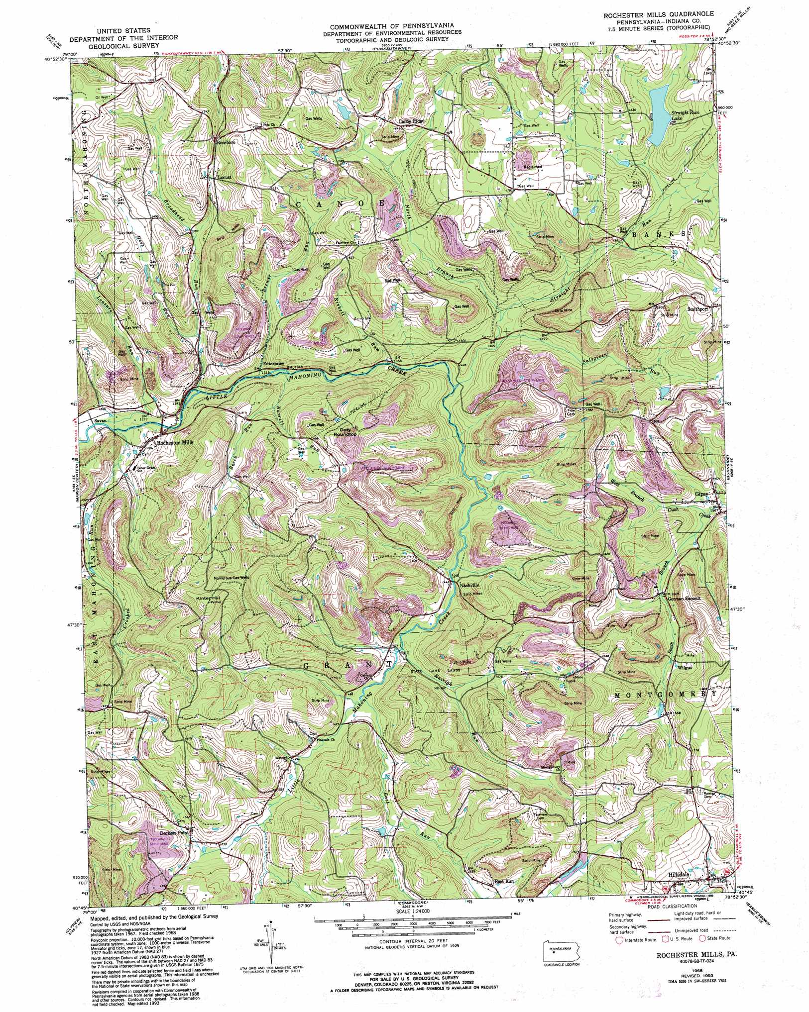
Rochester Mills Topo Map Pennsylvania
To zoom in, hover over the map of Rochester Mills
USGS Topo Quad 40078g8 - 1:24,000 scale
| Topo Map Name: | Rochester Mills |
| USGS Topo Quad ID: | 40078g8 |
| Print Size: | ca. 21 1/4" wide x 27" high |
| Southeast Coordinates: | 40.75° N latitude / 78.875° W longitude |
| Map Center Coordinates: | 40.8125° N latitude / 78.9375° W longitude |
| U.S. State: | PA |
| Filename: | o40078g8.jpg |
| Download Map JPG Image: | Rochester Mills topo map 1:24,000 scale |
| Map Type: | Topographic |
| Topo Series: | 7.5´ |
| Map Scale: | 1:24,000 |
| Source of Map Images: | United States Geological Survey (USGS) |
| Alternate Map Versions: |
Rochester Mills PA 1968, updated 1970 Download PDF Buy paper map Rochester Mills PA 1968, updated 1975 Download PDF Buy paper map Rochester Mills PA 1968, updated 1981 Download PDF Buy paper map Rochester Mills PA 1968, updated 1989 Download PDF Buy paper map Rochester Mills PA 1968, updated 1993 Download PDF Buy paper map Rochester Mills PA 2010 Download PDF Buy paper map Rochester Mills PA 2013 Download PDF Buy paper map Rochester Mills PA 2016 Download PDF Buy paper map |
1:24,000 Topo Quads surrounding Rochester Mills
Summerville |
Coolspring |
Reynoldsville |
Du Bois |
Luthersburg |
Dayton |
Valier |
Punxsutawney |
Mcgees Mills |
Mahaffey |
Plumville |
Marion Center |
Rochester Mills |
Burnside |
Westover |
Ernest |
Clymer |
Commodore |
Barnesboro |
Hastings |
Indiana |
Brush Valley |
Strongstown |
Colver |
Carrolltown |
> Back to 40078e1 at 1:100,000 scale
> Back to 40078a1 at 1:250,000 scale
> Back to U.S. Topo Maps home
Rochester Mills topo map: Gazetteer
Rochester Mills: Dams
Straight Run Dam elevation 524m 1719′Rochester Mills: Parks
Hemlock Lake County Park elevation 528m 1732′State Game Lands Number 262 elevation 451m 1479′
Rochester Mills: Populated Places
Canoe Ridge elevation 499m 1637′Deckers Point elevation 468m 1535′
East Run elevation 472m 1548′
Enterprise elevation 399m 1309′
Gipsy elevation 476m 1561′
Gorman Summit elevation 492m 1614′
Hillsdale elevation 513m 1683′
Locust elevation 439m 1440′
Nashville elevation 445m 1459′
Rochester Mills elevation 402m 1318′
Roseboro elevation 447m 1466′
Savan elevation 380m 1246′
Smithport elevation 553m 1814′
Wilgus elevation 494m 1620′
Rochester Mills: Reservoirs
Straight Run Lake elevation 524m 1719′Rochester Mills: Streams
Barrett Run elevation 403m 1322′Beech Run elevation 440m 1443′
Brewer Run elevation 402m 1318′
Broadhead Run elevation 390m 1279′
Crooked Run elevation 384m 1259′
East Run elevation 447m 1466′
Hess Run elevation 408m 1338′
Leasure Run elevation 383m 1256′
North Branch Straight Run elevation 429m 1407′
Pine Run elevation 459m 1505′
Rairigh Run elevation 444m 1456′
Rishell Run elevation 408m 1338′
Salsgiver Run elevation 433m 1420′
Straight Run elevation 414m 1358′
West Branch Cush Creek elevation 517m 1696′
Rochester Mills: Summits
Doty Roundtop elevation 579m 1899′Gorman Summit elevation 517m 1696′
Kinter Hill elevation 630m 2066′
Rochester Mills digital topo map on disk
Buy this Rochester Mills topo map showing relief, roads, GPS coordinates and other geographical features, as a high-resolution digital map file on DVD:
 map DVD")