Donegal Topo Map Pennsylvania
To zoom in, hover over the map of Donegal
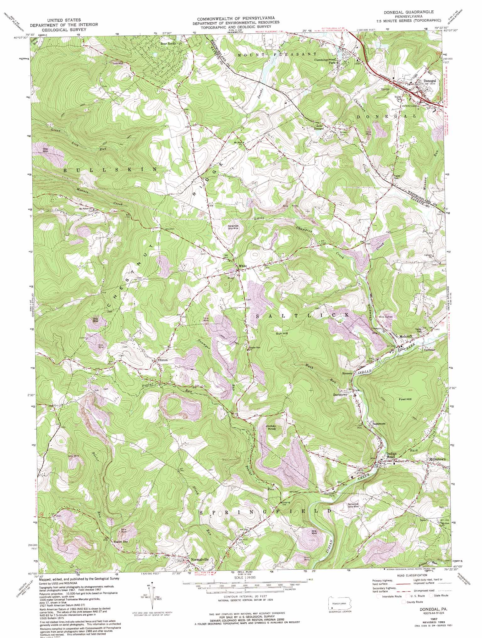
USGS Topo Quad 40079a4 - 1:24,000 scale
| Topo Map Name: | Donegal |
| USGS Topo Quad ID: | 40079a4 |
| Print Size: | ca. 21 1/4" wide x 27" high |
| Southeast Coordinates: | 40° N latitude / 79.375° W longitude |
| Map Center Coordinates: | 40.0625° N latitude / 79.4375° W longitude |
| U.S. State: | PA |
| Filename: | o40079a4.jpg |
| Download Map JPG Image: | Donegal topo map 1:24,000 scale |
| Map Type: | Topographic |
| Topo Series: | 7.5´ |
| Map Scale: | 1:24,000 |
| Source of Map Images: | United States Geological Survey (USGS) |
| Alternate Map Versions: |
Donegal PA 1967, updated 1971 Download PDF Buy paper map Donegal PA 1967, updated 1973 Download PDF Buy paper map Donegal PA 1967, updated 1979 Download PDF Buy paper map Donegal PA 1967, updated 1993 Download PDF Buy paper map Donegal PA 2010 Download PDF Buy paper map Donegal PA 2013 Download PDF Buy paper map Donegal PA 2016 Download PDF Buy paper map |
1:24,000 Topo Quads surrounding Donegal
Irwin |
Greensburg |
Latrobe |
Derry |
Wilpen |
Smithton |
Mount Pleasant |
Mammoth |
Stahlstown |
Ligonier |
Saint Clairsville |
Connellsville |
Donegal |
Seven Springs |
Bakersville |
Uniontown |
South Connellsville |
Mill Run |
Kingwood |
Rockwood |
Brownfield |
Fort Necessity |
Ohiopyle |
Confluence |
Markleton |
> Back to 40079a1 at 1:100,000 scale
> Back to 40078a1 at 1:250,000 scale
> Back to U.S. Topo Maps home
Donegal topo map: Gazetteer
Donegal: Crossings
Interchange elevation 529m 1735′Donegal: Populated Places
Bear Rocks elevation 608m 1994′Clinton elevation 611m 2004′
Coffman elevation 434m 1423′
Cummingswood Park elevation 552m 1811′
Davistown elevation 430m 1410′
Donegal elevation 553m 1814′
Indian Head elevation 429m 1407′
Melcroft elevation 432m 1417′
Millertown elevation 474m 1555′
Rasler Run elevation 499m 1637′
Romney elevation 429m 1407′
Sagamore elevation 426m 1397′
White elevation 586m 1922′
Donegal: Reservoirs
Lake Donegal elevation 563m 1847′Donegal: Streams
Back Creek elevation 423m 1387′Champion Creek elevation 432m 1417′
Little Champion Creek elevation 453m 1486′
Minnow Run elevation 478m 1568′
Newmyer Run elevation 492m 1614′
Poplar Run elevation 414m 1358′
South Spruce Run elevation 592m 1942′
Wash Run elevation 426m 1397′
Donegal: Summits
Fowl Hill elevation 587m 1925′Jockey Knob elevation 630m 2066′
Sun Hill elevation 655m 2148′
Donegal digital topo map on disk
Buy this Donegal topo map showing relief, roads, GPS coordinates and other geographical features, as a high-resolution digital map file on DVD:
 map DVD")