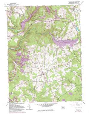
Brush Valley Topo Map Pennsylvania
To zoom in, hover over the map of Brush Valley
USGS Topo Quad 40079e1 - 1:24,000 scale
| Topo Map Name: | Brush Valley |
| USGS Topo Quad ID: | 40079e1 |
| Print Size: | ca. 21 1/4" wide x 27" high |
| Southeast Coordinates: | 40.5° N latitude / 79° W longitude |
| Map Center Coordinates: | 40.5625° N latitude / 79.0625° W longitude |
| U.S. State: | PA |
| Filename: | o40079e1.jpg |
| Download Map JPG Image: | Brush Valley topo map 1:24,000 scale |
| Map Type: | Topographic |
| Topo Series: | 7.5´ |
| Map Scale: | 1:24,000 |
| Source of Map Images: | United States Geological Survey (USGS) |
| Alternate Map Versions: |
Brush Valley PA 1963, updated 1965 Download PDF Buy paper map Brush Valley PA 1963, updated 1972 Download PDF Buy paper map Brush Valley PA 1963, updated 1973 Download PDF Buy paper map Brush Valley PA 1963, updated 1982 Download PDF Buy paper map Brush Valley PA 1998, updated 1999 Download PDF Buy paper map Brush Valley PA 2010 Download PDF Buy paper map Brush Valley PA 2013 Download PDF Buy paper map Brush Valley PA 2016 Download PDF Buy paper map |
1:24,000 Topo Quads surrounding Brush Valley
> Back to 40079e1 at 1:100,000 scale
> Back to 40078a1 at 1:250,000 scale
> Back to U.S. Topo Maps home
Brush Valley topo map: Gazetteer
Brush Valley: Airports
Bennett Airport elevation 412m 1351′Evans Field elevation 562m 1843′
Brush Valley: Cliffs
Suncliff elevation 452m 1482′Brush Valley: Dams
Elroy Face Dam elevation 445m 1459′Lucerne Dam elevation 400m 1312′
Pond Number Four Dam elevation 486m 1594′
Two Lick Creek Dam elevation 440m 1443′
Yellow Creek State Park Dam elevation 432m 1417′
Brush Valley: Parks
State Game Lands Number 248 elevation 443m 1453′State Game Lands Number 273 elevation 416m 1364′
Yellow Creek State Park elevation 401m 1315′
Brush Valley: Populated Places
Brush Valley elevation 440m 1443′Littletown elevation 504m 1653′
Luciusboro elevation 508m 1666′
Penn Run elevation 443m 1453′
Pikes Peak elevation 459m 1505′
Rico elevation 462m 1515′
Suncliff elevation 412m 1351′
Brush Valley: Reservoirs
Lake Margus elevation 445m 1459′Pond Number Four elevation 486m 1594′
Two Lick Creek Reservoir elevation 440m 1443′
Brush Valley: Streams
Ferrier Run elevation 362m 1187′Gillhouser Run elevation 427m 1400′
Laurel Run elevation 393m 1289′
Little Brush Creek elevation 411m 1348′
Little Yellow Creek elevation 392m 1286′
Ramsey Run elevation 339m 1112′
South Branch Brush Creek elevation 446m 1463′
Spruce Hollow Run elevation 462m 1515′
Brush Valley: Summits
Evans Hill elevation 552m 1811′Moose Hill elevation 587m 1925′
Strongs Hill elevation 555m 1820′
Brush Valley: Valleys
Spruce Hollow elevation 466m 1528′Brush Valley digital topo map on disk
Buy this Brush Valley topo map showing relief, roads, GPS coordinates and other geographical features, as a high-resolution digital map file on DVD:


