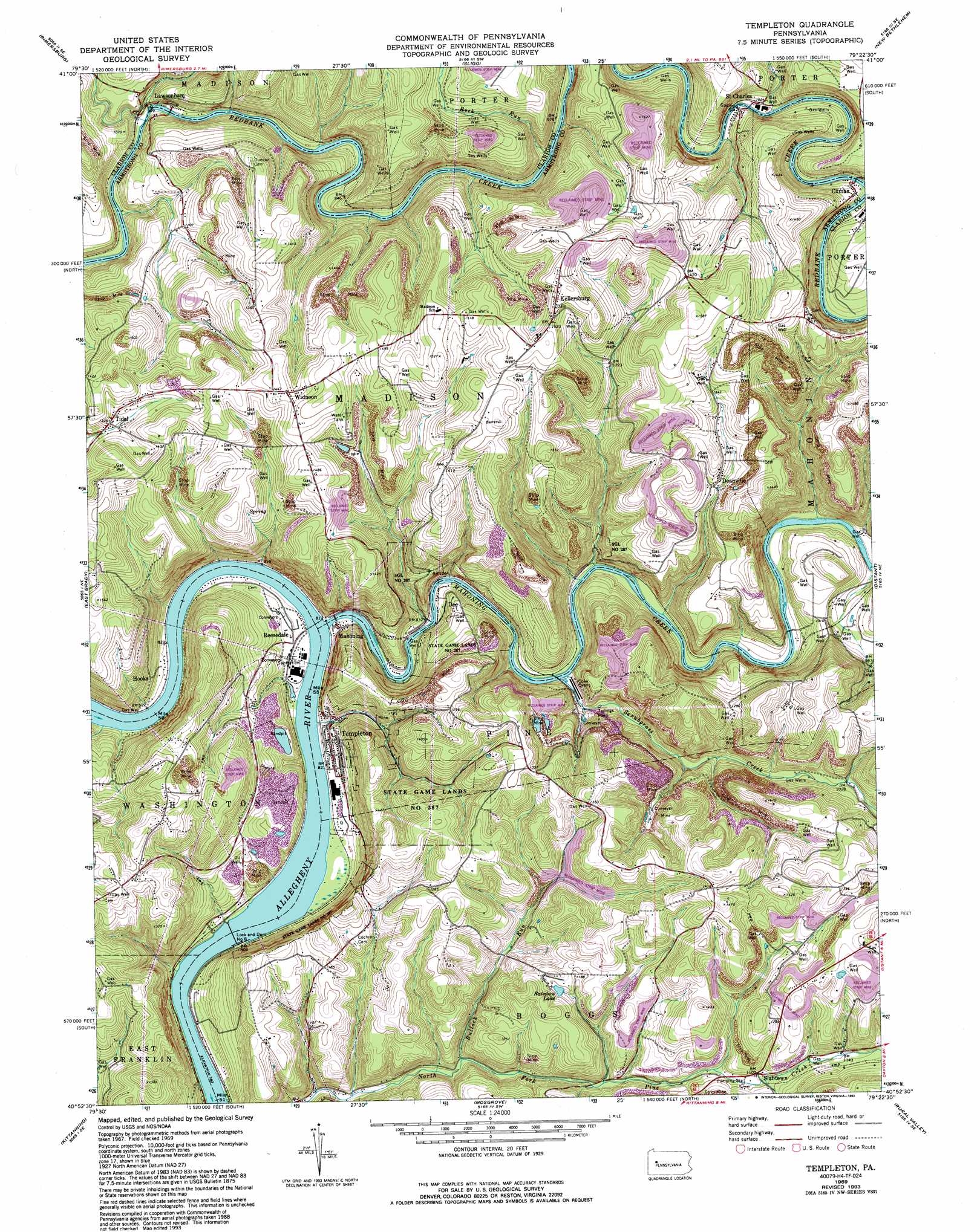
Templeton Topo Map Pennsylvania
To zoom in, hover over the map of Templeton
USGS Topo Quad 40079h4 - 1:24,000 scale
| Topo Map Name: | Templeton |
| USGS Topo Quad ID: | 40079h4 |
| Print Size: | ca. 21 1/4" wide x 27" high |
| Southeast Coordinates: | 40.875° N latitude / 79.375° W longitude |
| Map Center Coordinates: | 40.9375° N latitude / 79.4375° W longitude |
| U.S. State: | PA |
| Filename: | o40079h4.jpg |
| Download Map JPG Image: | Templeton topo map 1:24,000 scale |
| Map Type: | Topographic |
| Topo Series: | 7.5´ |
| Map Scale: | 1:24,000 |
| Source of Map Images: | United States Geological Survey (USGS) |
| Alternate Map Versions: |
Templeton PA 1969, updated 1972 Download PDF Buy paper map Templeton PA 1969, updated 1980 Download PDF Buy paper map Templeton PA 1969, updated 1980 Download PDF Buy paper map Templeton PA 1969, updated 1993 Download PDF Buy paper map Templeton PA 2010 Download PDF Buy paper map Templeton PA 2013 Download PDF Buy paper map Templeton PA 2016 Download PDF Buy paper map |
1:24,000 Topo Quads surrounding Templeton
Emlenton |
Knox |
Clarion |
Strattanville |
Corsica |
Parker |
Rimersburg |
Sligo |
New Bethlehem |
Summerville |
Chicora |
East Brady |
Templeton |
Distant |
Dayton |
Worthington |
Kittanning |
Mosgrove |
Rural Valley |
Plumville |
Freeport |
Leechburg |
Whitesburg |
Elderton |
Ernest |
> Back to 40079e1 at 1:100,000 scale
> Back to 40078a1 at 1:250,000 scale
> Back to U.S. Topo Maps home
Templeton topo map: Gazetteer
Templeton: Dams
Allegheny River Lock and Dam Eight elevation 238m 780′Mahoning Creek Mines Dam One and Two elevation 346m 1135′
Mahoning Creek Mines Dam One and Two elevation 275m 902′
Mahoning Creek Mines Dam One and Two elevation 362m 1187′
Templeton: Lakes
Rainbow Lake elevation 361m 1184′Templeton: Parks
State Game Lands Number 287 elevation 389m 1276′Templeton: Populated Places
Climax elevation 327m 1072′Deanville elevation 384m 1259′
Dee elevation 261m 856′
Hooks elevation 253m 830′
Kellersburg elevation 449m 1473′
Lawsonham elevation 277m 908′
Mahoning elevation 254m 833′
Reesedale elevation 262m 859′
Saint Charles elevation 316m 1036′
Slabtown elevation 336m 1102′
Templeton elevation 262m 859′
Tidal elevation 407m 1335′
Widnoon elevation 438m 1437′
Templeton: Reservoirs
Allegheny River Pool Eight elevation 238m 780′Pond Five elevation 346m 1135′
Pond One elevation 362m 1187′
Pond Two elevation 275m 902′
Templeton: Streams
Bullock Run elevation 279m 915′Leatherwood Creek elevation 299m 980′
Mahoning Creek elevation 244m 800′
Rock Run elevation 289m 948′
Scrubgrass Creek elevation 257m 843′
Wildcat Run elevation 262m 859′
Wiskey Creek elevation 250m 820′
Templeton digital topo map on disk
Buy this Templeton topo map showing relief, roads, GPS coordinates and other geographical features, as a high-resolution digital map file on DVD:
 map DVD")