Wheeling Topo Map West Virginia
To zoom in, hover over the map of Wheeling
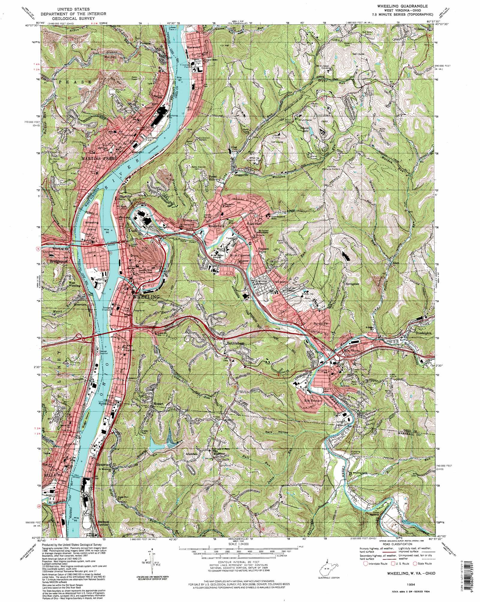
USGS Topo Quad 40080a6 - 1:24,000 scale
| Topo Map Name: | Wheeling |
| USGS Topo Quad ID: | 40080a6 |
| Print Size: | ca. 21 1/4" wide x 27" high |
| Southeast Coordinates: | 40° N latitude / 80.625° W longitude |
| Map Center Coordinates: | 40.0625° N latitude / 80.6875° W longitude |
| U.S. States: | WV, OH |
| Filename: | o40080a6.jpg |
| Download Map JPG Image: | Wheeling topo map 1:24,000 scale |
| Map Type: | Topographic |
| Topo Series: | 7.5´ |
| Map Scale: | 1:24,000 |
| Source of Map Images: | United States Geological Survey (USGS) |
| Alternate Map Versions: |
Wheeling WV 1956, updated 1958 Download PDF Buy paper map Wheeling WV 1956, updated 1963 Download PDF Buy paper map Wheeling WV 1968, updated 1971 Download PDF Buy paper map Wheeling WV 1968, updated 1978 Download PDF Buy paper map Wheeling WV 1968, updated 1984 Download PDF Buy paper map Wheeling WV 1968, updated 1992 Download PDF Buy paper map Wheeling WV 1994, updated 1998 Download PDF Buy paper map Wheeling WV 2011 Download PDF Buy paper map Wheeling WV 2014 Download PDF Buy paper map Wheeling WV 2016 Download PDF Buy paper map |
1:24,000 Topo Quads surrounding Wheeling
Cadiz |
Smithfield |
Steubenville West |
Steubenville East |
Avella |
Harrisville |
Dillonvale |
Tiltonsville |
Bethany |
West Middletown |
St Clairsville |
Lansing |
Wheeling |
Valley Grove |
Claysville |
Armstrongs Mills |
Businessburg |
Moundsville |
Majorsville |
Wind Ridge |
Cameron |
Powhatan Point |
Glen Easton |
Cameron |
New Freeport |
> Back to 40080a1 at 1:100,000 scale
> Back to 40080a1 at 1:250,000 scale
> Back to U.S. Topo Maps home
Wheeling topo map: Gazetteer
Wheeling: Airports
Bellaire Heliport elevation 201m 659′Ohio Valley Medical Center Heliport elevation 220m 721′
Warwood - Martins Ferry Seaplane Base elevation 193m 633′
Wheeling: Bars
McMahon Bar elevation 191m 626′Wheeling: Bridges
Bellaire Bridge elevation 191m 626′Fort Henry Bridge elevation 193m 633′
Wheeling Suspension Bridge elevation 193m 633′
Wheeling: Crossings
Interchange 1 elevation 205m 672′Interchange 1A elevation 211m 692′
Interchange 1B elevation 200m 656′
Interchange 2 elevation 357m 1171′
Interchange 225 elevation 202m 662′
Interchange 2A elevation 207m 679′
Interchange 2B elevation 207m 679′
Interchange 5 elevation 221m 725′
Wheeling: Dams
Browns Run Dam elevation 293m 961′Lock 12 (historical) elevation 193m 633′
Oglebay Park Lake Dam elevation 379m 1243′
Wheeling Creek Structure Number 18 Dam elevation 279m 915′
Wheeling: Flats
Peterson Bottom elevation 212m 695′Wheeling: Islands
Boggs Island elevation 194m 636′Boggs Island elevation 193m 633′
Wheeling Island elevation 198m 649′
Wheeling: Mines
Ayers Limestone Quarry elevation 363m 1190′Wheeling: Parks
Bridge Park elevation 198m 649′Carmichael Field elevation 199m 652′
Centre Market Square Historic District elevation 203m 666′
Chapline Street Row Historic District elevation 199m 652′
Eastern Park elevation 217m 711′
Edgewood Park elevation 209m 685′
Fodor Memorial Park elevation 216m 708′
Garden Park elevation 205m 672′
Hilltop Park elevation 381m 1250′
Nelson Field elevation 197m 646′
North Wheeling Historic District elevation 219m 718′
Oglebay Park elevation 356m 1167′
Pulaski Field elevation 199m 652′
Union Park elevation 202m 662′
Wheeling Historic District elevation 200m 656′
Wheeling Park elevation 242m 793′
Wilson Playground elevation 224m 734′
Wheeling: Populated Places
Aetnaville elevation 202m 662′Allendale elevation 388m 1272′
Bellaire elevation 203m 666′
Benwood elevation 197m 646′
Benwood Junction elevation 209m 685′
Bethlehem elevation 380m 1246′
Bridgeport elevation 200m 656′
Cedar Rocks elevation 266m 872′
Clinton elevation 295m 967′
Dawn Ree Acres elevation 370m 1213′
East Wheeling elevation 204m 669′
Echo Point elevation 220m 721′
Eden elevation 243m 797′
Edgewood elevation 206m 675′
Elm Grove elevation 236m 774′
Elm Terrace elevation 231m 757′
Florence elevation 203m 666′
Forest Hills elevation 314m 1030′
Fulton elevation 198m 649′
Glenns Run (historical) elevation 210m 688′
Glenwood elevation 242m 793′
Greggsville elevation 226m 741′
Hawthorne Court elevation 213m 698′
Leatherwood elevation 202m 662′
Leewood Park elevation 363m 1190′
Lombardy Heights elevation 227m 744′
Martins Ferry elevation 216m 708′
McCulley Estates elevation 364m 1194′
Mill Acres elevation 212m 695′
Mount de Chantal elevation 209m 685′
Mount Olivet elevation 389m 1276′
Mozart elevation 384m 1259′
Mozart Meadows elevation 380m 1246′
North Island elevation 199m 652′
North Park elevation 343m 1125′
North Wheeling elevation 215m 705′
Oakmont elevation 227m 744′
Oakmont Hills elevation 308m 1010′
Parkview elevation 237m 777′
Pleasant Valley elevation 214m 702′
Riverview elevation 203m 666′
South Island elevation 197m 646′
South Wheeling elevation 198m 649′
Springdale elevation 366m 1200′
Terminal Junction elevation 202m 662′
Triadelphia elevation 226m 741′
Upper Benwood elevation 198m 649′
Vineyard Hills elevation 271m 889′
Warwood elevation 205m 672′
Warwood Terrace elevation 240m 787′
West Wheeling elevation 306m 1003′
Wheeling elevation 203m 666′
Wheeling Heights elevation 229m 751′
Wildwood Acres elevation 348m 1141′
Winifred Knoll elevation 368m 1207′
Wolf Estates elevation 381m 1250′
Woodsdale elevation 203m 666′
Wheeling: Post Offices
Bellaire Post Office elevation 201m 659′Benwood Post Office elevation 198m 649′
Bridgeport Post Office elevation 199m 652′
Elm Grove Station Wheeling Post Office elevation 208m 682′
Martins Ferry Post Office elevation 216m 708′
Triadelphia Post Office elevation 223m 731′
Warwood Post Office elevation 209m 685′
West Wheeling Post Office (historical) elevation 302m 990′
Wheeling Post Office elevation 210m 688′
Wheeling: Reservoirs
Browns Run Impoundment elevation 293m 961′Schenk Lake elevation 337m 1105′
Wheeling: Springs
Baird Spring elevation 353m 1158′Boyd Spring elevation 365m 1197′
Brinkmeyer Spring elevation 294m 964′
Criswell Spring elevation 259m 849′
Davis Spring elevation 367m 1204′
George Rogerson Spring elevation 377m 1236′
Gray Spring elevation 305m 1000′
Hoffman Spring elevation 301m 987′
Miller Spring elevation 393m 1289′
Oglebay Drive Spring elevation 296m 971′
Oglebay Park Spring elevation 330m 1082′
Speidel Spring elevation 367m 1204′
Stifel Center Spring elevation 199m 652′
Stratford Saline Spring elevation 210m 688′
Stratford Spring elevation 210m 688′
Wheeling: Streams
Boggs Run elevation 202m 662′Britt Run elevation 214m 702′
Browns Run elevation 253m 830′
Browns Run elevation 215m 705′
Buckeye Run elevation 266m 872′
Bull Run elevation 270m 885′
Caldwell Run elevation 217m 711′
Carter Run elevation 225m 738′
George Run elevation 219m 718′
Glenns Run elevation 193m 633′
Glenns Run elevation 194m 636′
Grandstaff Run elevation 217m 711′
Indian Run elevation 201m 659′
Jakes Run elevation 212m 695′
Little Wheeling Creek elevation 204m 669′
Long Run elevation 195m 639′
McMahon Creek elevation 191m 626′
Middle Wheeling Creek elevation 219m 718′
Middle Wheeling Creek elevation 221m 725′
Moore Run elevation 193m 633′
Nixon Run elevation 206m 675′
Patton Run elevation 255m 836′
Peters Run elevation 214m 702′
Pogue Run elevation 288m 944′
Waddles Run elevation 220m 721′
Warden Run elevation 291m 954′
Wheeling Creek elevation 194m 636′
Wheeling Creek elevation 193m 633′
Whiskey Run elevation 193m 633′
Wheeling: Valleys
Dandelion Hollow elevation 204m 669′Dark Hollow elevation 239m 784′
Seabright Hollow elevation 217m 711′
Stackyard Hollow elevation 203m 666′
Wheeling digital topo map on disk
Buy this Wheeling topo map showing relief, roads, GPS coordinates and other geographical features, as a high-resolution digital map file on DVD:
 map DVD")