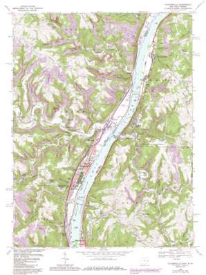
Tiltonsville Topo Map Ohio
To zoom in, hover over the map of Tiltonsville
USGS Topo Quad 40080b6 - 1:24,000 scale
| Topo Map Name: | Tiltonsville |
| USGS Topo Quad ID: | 40080b6 |
| Print Size: | ca. 21 1/4" wide x 27" high |
| Southeast Coordinates: | 40.125° N latitude / 80.625° W longitude |
| Map Center Coordinates: | 40.1875° N latitude / 80.6875° W longitude |
| U.S. States: | OH, WV |
| Filename: | o40080b6.jpg |
| Download Map JPG Image: | Tiltonsville topo map 1:24,000 scale |
| Map Type: | Topographic |
| Topo Series: | 7.5´ |
| Map Scale: | 1:24,000 |
| Source of Map Images: | United States Geological Survey (USGS) |
| Alternate Map Versions: |
Tiltonsville OH 1957, updated 1959 Download PDF Buy paper map Tiltonsville OH 1957, updated 1966 Download PDF Buy paper map Tiltonsville OH 1968, updated 1970 Download PDF Buy paper map Tiltonsville OH 1968, updated 1978 Download PDF Buy paper map Tiltonsville OH 1968, updated 1986 Download PDF Buy paper map Tiltonsville OH 1997, updated 2000 Download PDF Buy paper map Tiltonsville OH 1997, updated 2000 Download PDF Buy paper map Tiltonsville OH 2011 Download PDF Buy paper map Tiltonsville OH 2013 Download PDF Buy paper map Tiltonsville OH 2016 Download PDF Buy paper map |
1:24,000 Topo Quads surrounding Tiltonsville
> Back to 40080a1 at 1:100,000 scale
> Back to 40080a1 at 1:250,000 scale
> Back to U.S. Topo Maps home
Tiltonsville topo map: Gazetteer
Tiltonsville: Airports
Wheeling-Ohio County Airport elevation 357m 1171′Tiltonsville: Bars
Beech Bottom Bar (historical) elevation 196m 643′Short Creek Bar elevation 198m 649′
Tiltonsville: Dams
Lock and Dam Number 11 (historical) elevation 196m 643′Pike Island Lock and Dam elevation 199m 652′
Pike Island Lock and Dam elevation 197m 646′
Pike Island Locks and Dam elevation 196m 643′
Tiltonsville: Islands
Lower Twin Island elevation 199m 652′Upper Twin Island elevation 193m 633′
Tiltonsville: Mines
Windsor Mine elevation 277m 908′Tiltonsville: Parks
Mazeroski Park elevation 201m 659′Memorial Park elevation 202m 662′
Plummer Field elevation 203m 666′
Tiltonsville: Populated Places
Beech Bottom elevation 217m 711′Betty Zane elevation 387m 1269′
Bowman (historical) elevation 203m 666′
Clearview elevation 333m 1092′
Connor elevation 207m 679′
Connorville elevation 211m 692′
Glen Robbins elevation 246m 807′
Glen Run elevation 214m 702′
Glenndale (historical) elevation 201m 659′
Grandview Heights elevation 335m 1099′
Highland City elevation 206m 675′
Hopewell elevation 362m 1187′
Jackson Heights elevation 357m 1171′
Jug Run elevation 231m 757′
Pettit Heights elevation 372m 1220′
Power elevation 204m 669′
Rayland elevation 207m 679′
Rush Run elevation 217m 711′
Salt Run elevation 228m 748′
Shannon (historical) elevation 270m 885′
Short Creek elevation 207m 679′
Stringer elevation 200m 656′
Tiltonsville elevation 204m 669′
Upland Heights elevation 329m 1079′
Warrenton elevation 200m 656′
Willow Springs (historical) elevation 205m 672′
Wilson (historical) elevation 204m 669′
Windsor Heights elevation 306m 1003′
Yorkville elevation 204m 669′
Tiltonsville: Post Offices
Beech Bottom Post Office elevation 210m 688′Connorville Post Office (historical) elevation 206m 675′
Glen Robbins Post Office (historical) elevation 242m 793′
Rayland Post Office elevation 207m 679′
Rush Run Post Office (historical) elevation 216m 708′
Short Creek Post Office elevation 205m 672′
Tiltonsville Post Office elevation 204m 669′
Warrenton Post Office (historical) elevation 199m 652′
Windsor Heights Post Office elevation 306m 1003′
Yorkville Post Office elevation 210m 688′
Tiltonsville: Reservoirs
Pike Island Pool elevation 196m 643′Tiltonsville: Springs
Gray Spring elevation 325m 1066′Julian Kowczynski Spring elevation 377m 1236′
Martha Schell Spring elevation 357m 1171′
Orval McCardle Spring elevation 333m 1092′
Ray Albert Spring elevation 205m 672′
Stamp Spring elevation 336m 1102′
Tiltonsville: Streams
Blues Run elevation 223m 731′Deep Run elevation 199m 652′
Girty Run elevation 200m 656′
Huff Run elevation 265m 869′
Limestone Run elevation 252m 826′
Little Rush Run elevation 198m 649′
Little Short Creek elevation 196m 643′
Newlands Run elevation 222m 728′
North Fork Short Creek elevation 241m 790′
Patton Run elevation 198m 649′
Rush Run elevation 198m 649′
Salt Run elevation 196m 643′
Short Creek elevation 198m 649′
Short Creek elevation 198m 649′
Souttell Run elevation 251m 823′
Spring Run elevation 196m 643′
Waddles Run elevation 242m 793′
Williamson Run elevation 199m 652′
Tiltonsville: Valleys
Graeb Hollow elevation 218m 715′Limestone Hollow elevation 253m 830′
Stop 28 Hollow elevation 202m 662′
Tiltonsville digital topo map on disk
Buy this Tiltonsville topo map showing relief, roads, GPS coordinates and other geographical features, as a high-resolution digital map file on DVD:


