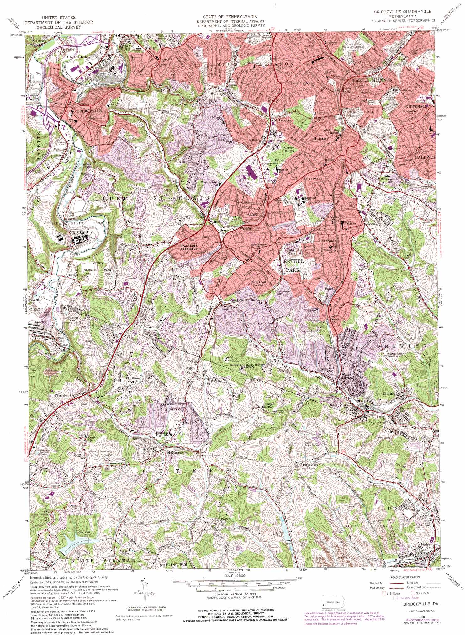
Bridgeville Topo Map Pennsylvania
To zoom in, hover over the map of Bridgeville
USGS Topo Quad 40080c1 - 1:24,000 scale
| Topo Map Name: | Bridgeville |
| USGS Topo Quad ID: | 40080c1 |
| Print Size: | ca. 21 1/4" wide x 27" high |
| Southeast Coordinates: | 40.25° N latitude / 80° W longitude |
| Map Center Coordinates: | 40.3125° N latitude / 80.0625° W longitude |
| U.S. State: | PA |
| Filename: | o40080c1.jpg |
| Download Map JPG Image: | Bridgeville topo map 1:24,000 scale |
| Map Type: | Topographic |
| Topo Series: | 7.5´ |
| Map Scale: | 1:24,000 |
| Source of Map Images: | United States Geological Survey (USGS) |
| Alternate Map Versions: |
Bridgeville PA 1953, updated 1955 Download PDF Buy paper map Bridgeville PA 1960, updated 1961 Download PDF Buy paper map Bridgeville PA 1960, updated 1966 Download PDF Buy paper map Bridgeville PA 1960, updated 1971 Download PDF Buy paper map Bridgeville PA 1960, updated 1979 Download PDF Buy paper map Bridgeville PA 1960, updated 1984 Download PDF Buy paper map Bridgeville PA 1960, updated 1984 Download PDF Buy paper map Bridgeville PA 1993, updated 1999 Download PDF Buy paper map Bridgeville PA 2010 Download PDF Buy paper map Bridgeville PA 2013 Download PDF Buy paper map Bridgeville PA 2016 Download PDF Buy paper map |
1:24,000 Topo Quads surrounding Bridgeville
Aliquippa |
Ambridge |
Emsworth |
Glenshaw |
New Kensington West |
Clinton |
Oakdale |
Pittsburgh West |
Pittsburgh East |
Braddock |
Midway |
Canonsburg |
Bridgeville |
Glassport |
Mckeesport |
Washington West |
Washington East |
Hackett |
Monongahela |
Donora |
Prosperity |
Amity |
Ellsworth |
California |
Fayette City |
> Back to 40080a1 at 1:100,000 scale
> Back to 40080a1 at 1:250,000 scale
> Back to U.S. Topo Maps home
Bridgeville topo map: Gazetteer
Bridgeville: Dams
Canonsburg Dam Number Two elevation 336m 1102′Lake Jo-Ann Dam elevation 315m 1033′
Laural Run Reservoir Dam elevation 328m 1076′
Trax Farm Dam elevation 343m 1125′
Bridgeville: Lakes
Cedar Lake elevation 328m 1076′Greer Pond elevation 302m 990′
Lynch Ponds elevation 256m 839′
Bridgeville: Parks
Mount Lebanon Park elevation 336m 1102′Bridgeville: Populated Places
Beadling elevation 280m 918′Bethel elevation 357m 1171′
Bethel Park elevation 365m 1197′
Bower Hill elevation 285m 935′
Bower Hill elevation 373m 1223′
Boyce elevation 268m 879′
Boyer elevation 327m 1072′
Bridgeville elevation 264m 866′
Brightwood elevation 379m 1243′
Broadlawn Highlands elevation 342m 1122′
Brookside elevation 325m 1066′
Bryn Mawr elevation 356m 1167′
Castle Shannon elevation 313m 1026′
Clifton elevation 295m 967′
Coverdale elevation 373m 1223′
Edgebrook elevation 308m 1010′
Essen elevation 286m 938′
Finleyville elevation 291m 954′
Garvey Melton elevation 373m 1223′
Hillcrest elevation 344m 1128′
Jewell elevation 370m 1213′
Kirwan Heights elevation 275m 902′
Lawrence elevation 311m 1020′
Library elevation 299m 980′
Library Junction elevation 342m 1122′
Linden Grove elevation 308m 1010′
Longview elevation 352m 1154′
McMurray elevation 303m 994′
Mollenauer elevation 347m 1138′
Mount Lebanon elevation 323m 1059′
Presto elevation 251m 823′
Ruthfred Acres elevation 358m 1174′
Salida elevation 358m 1174′
Thompsonville elevation 286m 938′
Turkeyfoot elevation 351m 1151′
Upper Saint Clair elevation 335m 1099′
Walther elevation 345m 1131′
Washington Junction elevation 336m 1102′
West Library elevation 351m 1151′
Bridgeville: Post Offices
Bethel Park Post Office elevation 356m 1167′Borland Post Office (historical) elevation 265m 869′
Bower Hill Post Office (historical) elevation 285m 935′
Bridgeville Post Office elevation 249m 816′
Finleyville Post Office elevation 295m 967′
Lawrence Post Office (historical) elevation 311m 1020′
Presto Post Office elevation 249m 816′
South Park Post Office elevation 292m 958′
Village Post Office elevation 346m 1135′
Bridgeville: Reservoirs
Canonsburg Number Two Reservoir elevation 336m 1102′Lake Jo-Ann elevation 314m 1030′
Lehner Lakes elevation 330m 1082′
Number Two Reservoir elevation 314m 1030′
Bridgeville: Streams
Brush Run elevation 262m 859′Coal Run elevation 250m 820′
Graesers Run elevation 297m 974′
McLaughlin Run elevation 247m 810′
Millers Run elevation 250m 820′
Painters Run elevation 246m 807′
Sleepy Hollow Run elevation 284m 931′
Thoms Run elevation 250m 820′
Bridgeville: Tunnels
Greer Tunnel elevation 340m 1115′Montour Tunnel elevation 328m 1076′
Bridgeville: Valleys
Sleepy Hollow elevation 285m 935′Bridgeville digital topo map on disk
Buy this Bridgeville topo map showing relief, roads, GPS coordinates and other geographical features, as a high-resolution digital map file on DVD:
 map DVD")