Steubenville East Topo Map West Virginia
To zoom in, hover over the map of Steubenville East
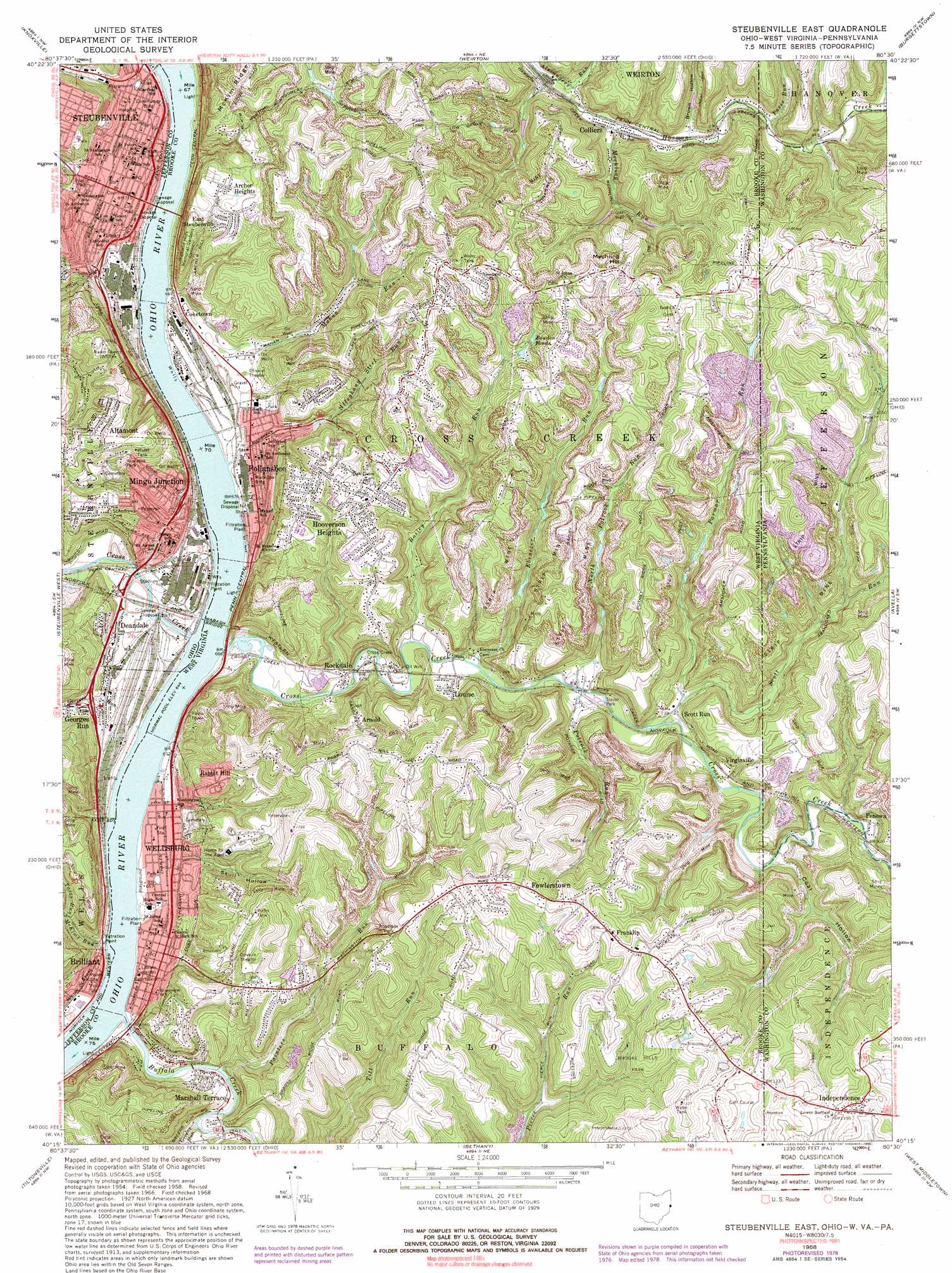
USGS Topo Quad 40080c5 - 1:24,000 scale
| Topo Map Name: | Steubenville East |
| USGS Topo Quad ID: | 40080c5 |
| Print Size: | ca. 21 1/4" wide x 27" high |
| Southeast Coordinates: | 40.25° N latitude / 80.5° W longitude |
| Map Center Coordinates: | 40.3125° N latitude / 80.5625° W longitude |
| U.S. States: | WV, PA, OH |
| Filename: | o40080c5.jpg |
| Download Map JPG Image: | Steubenville East topo map 1:24,000 scale |
| Map Type: | Topographic |
| Topo Series: | 7.5´ |
| Map Scale: | 1:24,000 |
| Source of Map Images: | United States Geological Survey (USGS) |
| Alternate Map Versions: |
Steubenville East OH 1958, updated 1959 Download PDF Buy paper map Steubenville East OH 1958, updated 1966 Download PDF Buy paper map Steubenville East OH 1968, updated 1970 Download PDF Buy paper map Steubenville East OH 1968, updated 1978 Download PDF Buy paper map Steubenville East OH 1968, updated 1990 Download PDF Buy paper map Steubenville East OH 1997, updated 1999 Download PDF Buy paper map Steubenville East OH 2010 Download PDF Buy paper map Steubenville East OH 2013 Download PDF Buy paper map Steubenville East OH 2016 Download PDF Buy paper map |
1:24,000 Topo Quads surrounding Steubenville East
Salineville |
Wellsville |
East Liverpool South |
Hookstown |
Aliquippa |
Richmond |
Knoxville |
Weirton |
Burgettstown |
Clinton |
Smithfield |
Steubenville West |
Steubenville East |
Avella |
Midway |
Dillonvale |
Tiltonsville |
Bethany |
West Middletown |
Washington West |
Lansing |
Wheeling |
Valley Grove |
Claysville |
Prosperity |
> Back to 40080a1 at 1:100,000 scale
> Back to 40080a1 at 1:250,000 scale
> Back to U.S. Topo Maps home
Steubenville East topo map: Gazetteer
Steubenville East: Airports
Wellsburg Seaplane Base elevation 197m 646′Steubenville East: Bars
Wells Creek Bar elevation 198m 649′Steubenville East: Bridges
Market Street Bridge elevation 199m 652′Wabash Bridge elevation 198m 649′
Wapash Bridge elevation 198m 649′
Steubenville East: Dams
Harmon Creek Structure Number 13 Dam elevation 261m 856′Harmon Creek Structure Number Four Dam elevation 306m 1003′
Harmon Creek Structure Number Three Dam elevation 334m 1095′
Harmon Creek Structure Number Two Dam elevation 263m 862′
Memorial Lake Dam elevation 309m 1013′
Pa-486 Dam elevation 274m 898′
Steubenville East: Flats
Mingo Bottom elevation 202m 662′Steubenville East: Parks
Aracoma Park elevation 301m 987′Beatty Park Number 2 elevation 257m 843′
Brooke Hills Park elevation 321m 1053′
Commercial Street Historic District elevation 222m 728′
Fort Steuben Historical Site elevation 217m 711′
North Hill Historic District elevation 290m 951′
Steubenville Commercial Historic District elevation 220m 721′
Steubenville East: Populated Places
Altamont elevation 346m 1135′Archer Heights elevation 301m 987′
Arnold elevation 304m 997′
Chapman Addition elevation 382m 1253′
Coketown elevation 215m 705′
Colliers elevation 243m 797′
Deandale elevation 207m 679′
Dutch Town elevation 200m 656′
Duvall's Trailer Park elevation 211m 692′
East Steubenville elevation 295m 967′
Follansbee elevation 204m 669′
Fowlerstown elevation 375m 1230′
Franklin elevation 366m 1200′
Hooverson Heights elevation 311m 1020′
Independence elevation 370m 1213′
Jacksonville elevation 212m 695′
Jeffersonville (historical) elevation 203m 666′
La Belle View elevation 329m 1079′
Lazearville elevation 203m 666′
Longview Heights elevation 353m 1158′
Louise elevation 221m 725′
Marshall Terrace elevation 213m 698′
Mingo Junction elevation 243m 797′
Moores Trailer Park elevation 212m 695′
Parkview elevation 298m 977′
Penowa elevation 245m 803′
Rabbit Hill elevation 298m 977′
Rockdale elevation 214m 702′
Scott Run elevation 225m 738′
Shank Town elevation 201m 659′
The Orchard elevation 222m 728′
Virginville elevation 240m 787′
Wellsburg elevation 206m 675′
Steubenville East: Post Offices
Follansbee Post Office elevation 204m 669′Mingo Junction Post Office elevation 206m 675′
Steubenville Post Office elevation 218m 715′
Wellsburg Post Office elevation 202m 662′
Steubenville East: Reservoirs
Bowden Ponds elevation 317m 1040′Steubenville East: Streams
Alleghany Steel Run elevation 198m 649′Bosley Run elevation 210m 688′
Buffalo Creek elevation 197m 646′
Buffalo Creek elevation 197m 646′
Cross Creek elevation 198m 649′
Cross Creek elevation 198m 649′
Cross Creek elevation 198m 649′
Ebenezer Run elevation 213m 698′
Georges Run elevation 198m 649′
Greens Run elevation 200m 656′
Mahan Run elevation 198m 649′
McKims Run elevation 219m 718′
Mechling Run elevation 240m 787′
North Potrock Run elevation 217m 711′
Painters Run elevation 204m 669′
Paris Run elevation 252m 826′
Parmar Run elevation 227m 744′
Permars Run elevation 220m 721′
Potrock Run elevation 217m 711′
Scott Run elevation 222m 728′
Scott Run elevation 222m 728′
Tarrs Run elevation 201m 659′
Steubenville East: Summits
Mechling Hill elevation 380m 1246′Steubenville East: Tunnels
Coen Tunnel elevation 258m 846′State Line Tunnel elevation 299m 980′
Wellsburg Tunnel elevation 219m 718′
Steubenville East: Valleys
Brown Hollow elevation 249m 816′Coal Hollow elevation 237m 777′
Number Two Hollow elevation 240m 787′
Skull Hollow elevation 212m 695′
Steubenville East digital topo map on disk
Buy this Steubenville East topo map showing relief, roads, GPS coordinates and other geographical features, as a high-resolution digital map file on DVD:
 map DVD")