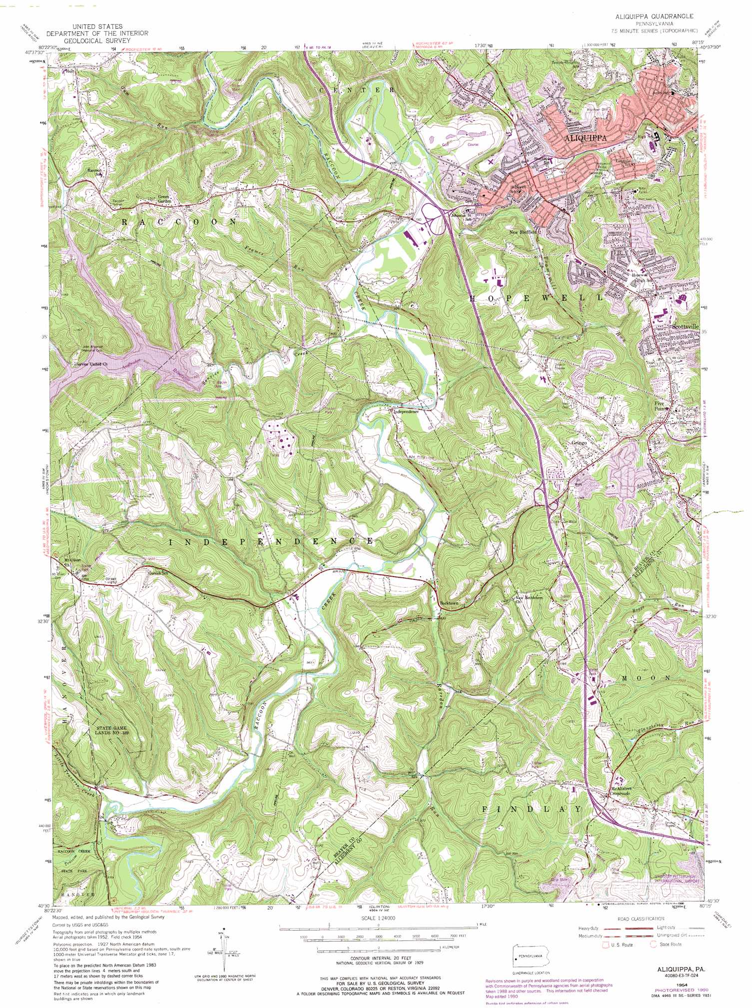
Aliquippa Topo Map Pennsylvania
To zoom in, hover over the map of Aliquippa
USGS Topo Quad 40080e3 - 1:24,000 scale
| Topo Map Name: | Aliquippa |
| USGS Topo Quad ID: | 40080e3 |
| Print Size: | ca. 21 1/4" wide x 27" high |
| Southeast Coordinates: | 40.5° N latitude / 80.25° W longitude |
| Map Center Coordinates: | 40.5625° N latitude / 80.3125° W longitude |
| U.S. State: | PA |
| Filename: | o40080e3.jpg |
| Download Map JPG Image: | Aliquippa topo map 1:24,000 scale |
| Map Type: | Topographic |
| Topo Series: | 7.5´ |
| Map Scale: | 1:24,000 |
| Source of Map Images: | United States Geological Survey (USGS) |
| Alternate Map Versions: |
Aliquippa PA 1954, updated 1955 Download PDF Buy paper map Aliquippa PA 1954, updated 1965 Download PDF Buy paper map Aliquippa PA 1954, updated 1970 Download PDF Buy paper map Aliquippa PA 1954, updated 1980 Download PDF Buy paper map Aliquippa PA 1954, updated 1990 Download PDF Buy paper map Aliquippa PA 1954, updated 1990 Download PDF Buy paper map Aliquippa PA 2010 Download PDF Buy paper map Aliquippa PA 2013 Download PDF Buy paper map Aliquippa PA 2016 Download PDF Buy paper map |
1:24,000 Topo Quads surrounding Aliquippa
East Palestine |
New Galilee |
Beaver Falls |
Zelienople |
Evans City |
East Liverpool North |
Midland |
Beaver |
Baden |
Mars |
East Liverpool South |
Hookstown |
Aliquippa |
Ambridge |
Emsworth |
Weirton |
Burgettstown |
Clinton |
Oakdale |
Pittsburgh West |
Steubenville East |
Avella |
Midway |
Canonsburg |
Bridgeville |
> Back to 40080e1 at 1:100,000 scale
> Back to 40080a1 at 1:250,000 scale
> Back to U.S. Topo Maps home
Aliquippa topo map: Gazetteer
Aliquippa: Airports
Aliquippa Hospital Airport elevation 282m 925′Aliquippa: Bridges
Hollywood Bridge elevation 258m 846′Aliquippa: Dams
J C Bacon Dam elevation 276m 905′Aliquippa: Parks
Moree Field elevation 276m 905′State Game Lands Number 189 elevation 369m 1210′
Aliquippa: Populated Places
Bocktown elevation 257m 843′Crestmont Village elevation 361m 1184′
Davidson Heights elevation 351m 1151′
Five Points elevation 351m 1151′
Gringo elevation 359m 1177′
Holt elevation 339m 1112′
Independence elevation 243m 797′
McAlisters Crossroads elevation 374m 1227′
New Sheffield elevation 291m 954′
Scottsville elevation 359m 1177′
Aliquippa: Post Offices
MacArthur Post Office elevation 281m 921′Aliquippa: Reservoirs
Ambridge Reservoir elevation 286m 938′Service Creek Reservoir elevation 276m 905′
Aliquippa: Streams
Frames Run elevation 234m 767′Gums Run elevation 221m 725′
Little Traverse Creek elevation 255m 836′
Obney Run elevation 248m 813′
Raredon Run elevation 243m 797′
Service Creek elevation 236m 774′
Trampmill Run elevation 235m 770′
Traverse Creek elevation 259m 849′
Aliquippa digital topo map on disk
Buy this Aliquippa topo map showing relief, roads, GPS coordinates and other geographical features, as a high-resolution digital map file on DVD:
 map DVD")