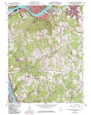
East Liverpool South Topo Map West Virginia
To zoom in, hover over the map of East Liverpool South
USGS Topo Quad 40080e5 - 1:24,000 scale
| Topo Map Name: | East Liverpool South |
| USGS Topo Quad ID: | 40080e5 |
| Print Size: | ca. 21 1/4" wide x 27" high |
| Southeast Coordinates: | 40.5° N latitude / 80.5° W longitude |
| Map Center Coordinates: | 40.5625° N latitude / 80.5625° W longitude |
| U.S. States: | WV, OH, PA |
| Filename: | o40080e5.jpg |
| Download Map JPG Image: | East Liverpool South topo map 1:24,000 scale |
| Map Type: | Topographic |
| Topo Series: | 7.5´ |
| Map Scale: | 1:24,000 |
| Source of Map Images: | United States Geological Survey (USGS) |
| Alternate Map Versions: |
East Liverpool South OH 1960, updated 1962 Download PDF Buy paper map East Liverpool South OH 1960, updated 1965 Download PDF Buy paper map East Liverpool South OH 1960, updated 1972 Download PDF Buy paper map East Liverpool South OH 1960, updated 1978 Download PDF Buy paper map East Liverpool South OH 1960, updated 1985 Download PDF Buy paper map East Liverpool South OH 1960, updated 1985 Download PDF Buy paper map East Liverpool South OH 1996, updated 1999 Download PDF Buy paper map East Liverpool South OH 2011 Download PDF Buy paper map East Liverpool South OH 2013 Download PDF Buy paper map East Liverpool South OH 2016 Download PDF Buy paper map |
1:24,000 Topo Quads surrounding East Liverpool South
> Back to 40080e1 at 1:100,000 scale
> Back to 40080a1 at 1:250,000 scale
> Back to U.S. Topo Maps home
East Liverpool South topo map: Gazetteer
East Liverpool South: Airports
Herron Airport elevation 368m 1207′East Liverpool South: Bridges
Jennings Randolph Memorial Bridge elevation 205m 672′Newell Bridge elevation 203m 666′
Newell Bridge elevation 204m 669′
East Liverpool South: Dams
Lock and Dam Number 8 (historical) elevation 204m 669′Lock and Dam Number 9 (historical) elevation 201m 659′
New Cumberland Locks and Dam elevation 201m 659′
Tomlinson Run Dam elevation 270m 885′
East Liverpool South: Lakes
Tomlinson Run Lake elevation 274m 898′East Liverpool South: Parks
Clarke Athletic Field elevation 229m 751′Diamond Historic District elevation 235m 770′
East Fifth Street Historic District elevation 235m 770′
Hillcrest Wildlife Management Area elevation 369m 1210′
Tomlinson Run State Park elevation 333m 1092′
East Liverpool South: Populated Places
Chester elevation 215m 705′East Liverpool elevation 234m 767′
Empire elevation 208m 682′
Fairhaven elevation 310m 1017′
Lawrenceville elevation 298m 977′
New Manchester elevation 362m 1187′
Newell elevation 230m 754′
Turkeyfoot (historical) elevation 393m 1289′
Walkers elevation 210m 688′
East Liverpool South: Post Offices
Chester Post Office elevation 214m 702′East Liverpool Post Office elevation 234m 767′
Empire Post Office elevation 206m 675′
New Manchester Post Office elevation 365m 1197′
Newell Post Office elevation 232m 761′
Walkers Post Office (historical) elevation 209m 685′
East Liverpool South: Reservoirs
Cherry Lake elevation 314m 1030′New Cumberland Pool elevation 201m 659′
East Liverpool South: Springs
Conservation Commission Spring elevation 310m 1017′East Liverpool South: Streams
Carpenter Run elevation 203m 666′Cunningham Run elevation 206m 675′
Deep Gut Run elevation 200m 656′
Hardin Run elevation 199m 652′
Herron Run elevation 251m 823′
Jeremy Run elevation 200m 656′
Jethroe Run elevation 205m 672′
Langfitt Run elevation 296m 971′
Marks Run elevation 205m 672′
Mercer Run elevation 297m 974′
Middle Run elevation 205m 672′
Muchmores Run elevation 204m 669′
North Fork Tomlinson Run elevation 279m 915′
South Fork Tomlinson Run elevation 281m 921′
South Fork Tomlinson Run elevation 281m 921′
Whiteoak Run elevation 270m 885′
East Liverpool South: Summits
Stewart Hill elevation 412m 1351′East Liverpool South: Valleys
California Hollow elevation 204m 669′Laurel Hollow elevation 215m 705′
Shepherds Valley elevation 279m 915′
East Liverpool South digital topo map on disk
Buy this East Liverpool South topo map showing relief, roads, GPS coordinates and other geographical features, as a high-resolution digital map file on DVD:


