East Liverpool North Topo Map Ohio
To zoom in, hover over the map of East Liverpool North
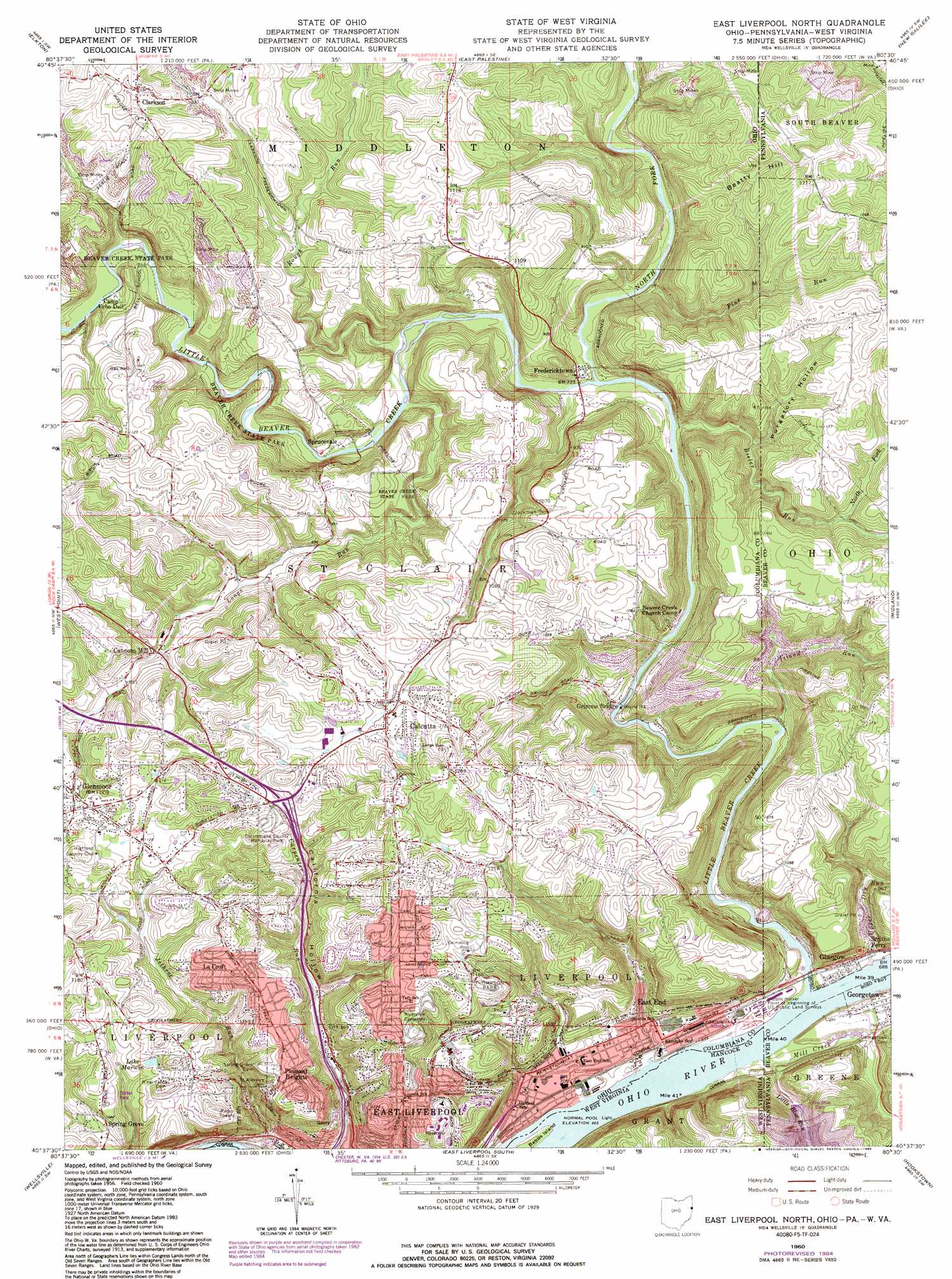
USGS Topo Quad 40080f5 - 1:24,000 scale
| Topo Map Name: | East Liverpool North |
| USGS Topo Quad ID: | 40080f5 |
| Print Size: | ca. 21 1/4" wide x 27" high |
| Southeast Coordinates: | 40.625° N latitude / 80.5° W longitude |
| Map Center Coordinates: | 40.6875° N latitude / 80.5625° W longitude |
| U.S. States: | OH, WV, PA |
| Filename: | o40080f5.jpg |
| Download Map JPG Image: | East Liverpool North topo map 1:24,000 scale |
| Map Type: | Topographic |
| Topo Series: | 7.5´ |
| Map Scale: | 1:24,000 |
| Source of Map Images: | United States Geological Survey (USGS) |
| Alternate Map Versions: |
East Liverpool North OH 1960, updated 1962 Download PDF Buy paper map East Liverpool North OH 1960, updated 1968 Download PDF Buy paper map East Liverpool North OH 1960, updated 1972 Download PDF Buy paper map East Liverpool North OH 1960, updated 1978 Download PDF Buy paper map East Liverpool North OH 1960, updated 1985 Download PDF Buy paper map East Liverpool North OH 1960, updated 1985 Download PDF Buy paper map East Liverpool North OH 1994, updated 1998 Download PDF Buy paper map East Liverpool North OH 2011 Download PDF Buy paper map East Liverpool North OH 2013 Download PDF Buy paper map East Liverpool North OH 2016 Download PDF Buy paper map |
1:24,000 Topo Quads surrounding East Liverpool North
Salem |
Columbiana |
New Middletown |
Bessemer |
New Castle South |
Lisbon |
Elkton |
East Palestine |
New Galilee |
Beaver Falls |
Gavers |
West Point |
East Liverpool North |
Midland |
Beaver |
Salineville |
Wellsville |
East Liverpool South |
Hookstown |
Aliquippa |
Richmond |
Knoxville |
Weirton |
Burgettstown |
Clinton |
> Back to 40080e1 at 1:100,000 scale
> Back to 40080a1 at 1:250,000 scale
> Back to U.S. Topo Maps home
East Liverpool North topo map: Gazetteer
East Liverpool North: Airports
East Liverpool Seaplane Base elevation 358m 1174′East Liverpool North: Dams
Little Blue Run Dam elevation 309m 1013′East Liverpool North: Islands
Babbs Island elevation 207m 679′Line Island (historical) elevation 204m 669′
East Liverpool North: Lakes
Lake Marwin elevation 342m 1122′East Liverpool North: Parks
Columbian Park elevation 227m 744′Thompson Park elevation 300m 984′
East Liverpool North: Populated Places
Calcutta elevation 340m 1115′Cannons Mill elevation 288m 944′
Clarkson elevation 359m 1177′
Dry Run elevation 218m 715′
East End elevation 221m 725′
Echo Dell Mobile Home Park elevation 340m 1115′
Farr Hill Mobile Home Park elevation 332m 1089′
Fredericktown elevation 268m 879′
Glasgow elevation 208m 682′
Glendale elevation 228m 748′
Glenmoor elevation 342m 1122′
Grimms Bridge elevation 221m 725′
Jethro elevation 204m 669′
La Croft elevation 357m 1171′
Mount Acres Trailer Park elevation 342m 1122′
Pleasant Heights elevation 357m 1171′
Santa Clara Estates elevation 357m 1171′
Shadybrook Trailer Park elevation 336m 1102′
Smiths Ferry elevation 214m 702′
Spring Grove elevation 305m 1000′
Sprucevale elevation 241m 790′
East Liverpool North: Post Offices
Calcutta Post Office (historical) elevation 340m 1115′Cannons Mill Post Office (historical) elevation 286m 938′
Clarkson Post Office (historical) elevation 363m 1190′
Sprucevale Post Office (historical) elevation 241m 790′
East Liverpool North: Streams
Bieler Run elevation 225m 738′Dry Run elevation 204m 669′
East Branch Pine Run elevation 289m 948′
Island Run elevation 217m 711′
Little Beaver Creek elevation 204m 669′
Little Beaver Creek elevation 204m 669′
Little Blue Run elevation 207m 679′
Longs Run elevation 237m 777′
Mill Creek elevation 204m 669′
North Fork Bieler Run elevation 293m 961′
North Fork Little Beaver Creek elevation 225m 738′
Pine Run elevation 231m 757′
Pine Run elevation 248m 813′
Purgatory Run elevation 244m 800′
Rough Run elevation 256m 839′
Upper Dry Run elevation 206m 675′
East Liverpool North: Summits
Beatty Hill elevation 380m 1246′Beatty Hill elevation 380m 1246′
East Liverpool North: Trails
Dogwood Trail elevation 250m 820′Fishermans Trail elevation 239m 784′
Gretchens Lock Trail elevation 240m 787′
Vondergreen Trail elevation 245m 803′
East Liverpool North: Valleys
Purgatory Hollow elevation 256m 839′Sheepskin Hollow elevation 249m 816′
East Liverpool North digital topo map on disk
Buy this East Liverpool North topo map showing relief, roads, GPS coordinates and other geographical features, as a high-resolution digital map file on DVD:
 map DVD")