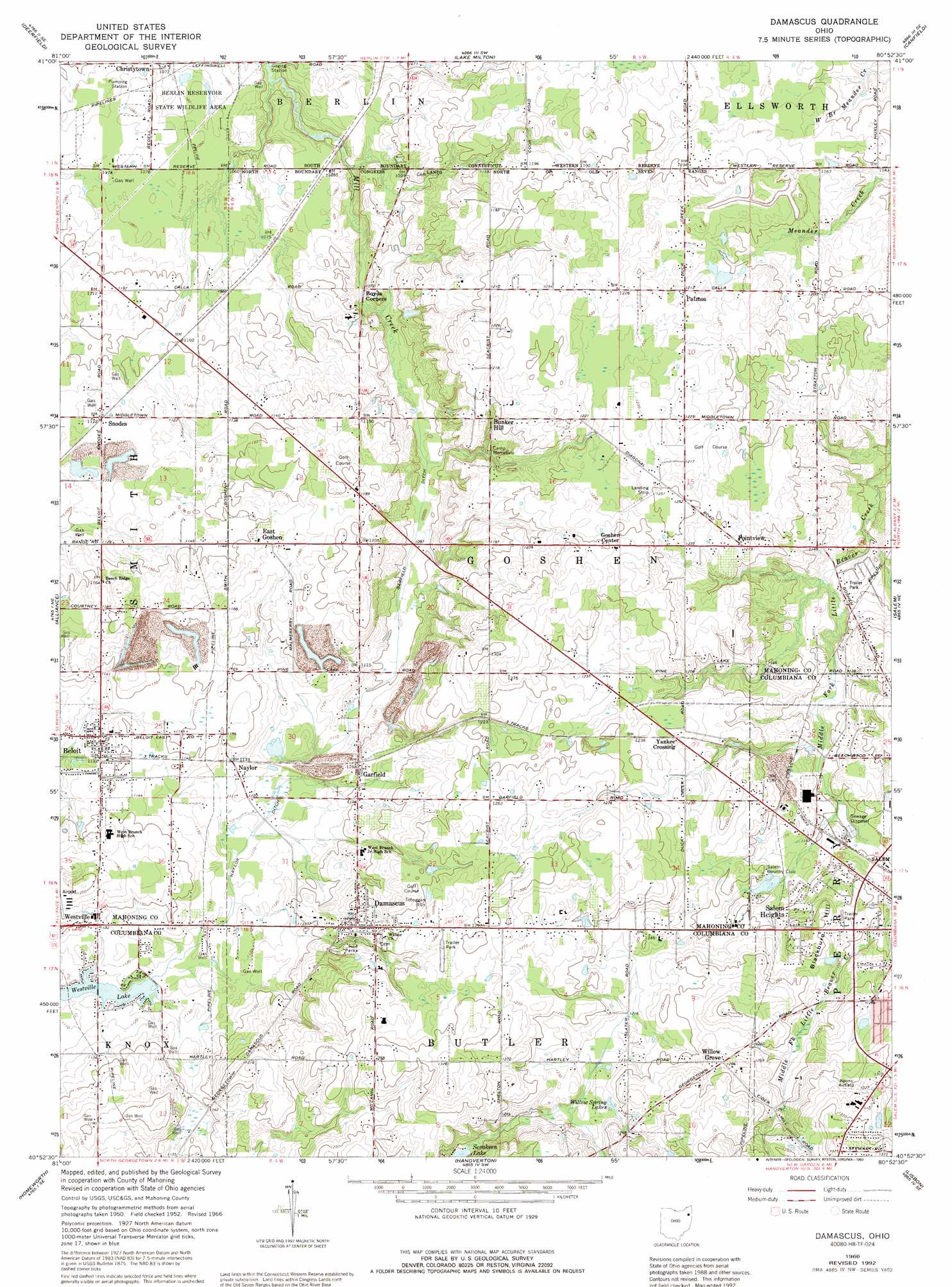
Damascus Topo Map Ohio
To zoom in, hover over the map of Damascus
USGS Topo Quad 40080h8 - 1:24,000 scale
| Topo Map Name: | Damascus |
| USGS Topo Quad ID: | 40080h8 |
| Print Size: | ca. 21 1/4" wide x 27" high |
| Southeast Coordinates: | 40.875° N latitude / 80.875° W longitude |
| Map Center Coordinates: | 40.9375° N latitude / 80.9375° W longitude |
| U.S. State: | OH |
| Filename: | o40080h8.jpg |
| Download Map JPG Image: | Damascus topo map 1:24,000 scale |
| Map Type: | Topographic |
| Topo Series: | 7.5´ |
| Map Scale: | 1:24,000 |
| Source of Map Images: | United States Geological Survey (USGS) |
| Alternate Map Versions: |
Damascus OH 1952, updated 1954 Download PDF Buy paper map Damascus OH 1966, updated 1968 Download PDF Buy paper map Damascus OH 1966, updated 1992 Download PDF Buy paper map Damascus OH 1994, updated 1997 Download PDF Buy paper map Damascus OH 2010 Download PDF Buy paper map Damascus OH 2013 Download PDF Buy paper map Damascus OH 2016 Download PDF Buy paper map |
1:24,000 Topo Quads surrounding Damascus
Ravenna |
Windham |
Newton Falls |
Warren |
Girard |
Atwater |
Deerfield |
Lake Milton |
Canfield |
Youngstown |
Limaville |
Alliance |
Damascus |
Salem |
Columbiana |
Robertsville |
Homeworth |
Hanoverton |
Lisbon |
Elkton |
Malvern |
Minerva |
Kensington |
Gavers |
West Point |
> Back to 40080e1 at 1:100,000 scale
> Back to 40080a1 at 1:250,000 scale
> Back to U.S. Topo Maps home
Damascus topo map: Gazetteer
Damascus: Airports
Koons Airport elevation 400m 1312′O K Dies Airport elevation 386m 1266′
Ponderosa Heliport elevation 330m 1082′
Tri-City Airport elevation 360m 1181′
Damascus: Canals
Garfield Ditch elevation 333m 1092′Naylor Ditch elevation 338m 1108′
Damascus: Lakes
Willow Spring Lakes elevation 373m 1223′Damascus: Populated Places
Beloit elevation 344m 1128′Boswell (historical) elevation 361m 1184′
Bunker Hill elevation 362m 1187′
Butler Mobile City elevation 390m 1279′
C And C Mobile Home Community elevation 371m 1217′
Christytown elevation 327m 1072′
Damascus elevation 371m 1217′
East Goshen elevation 354m 1161′
Garfield elevation 354m 1161′
Naylor elevation 341m 1118′
Patmos elevation 370m 1213′
Pointview elevation 372m 1220′
Salem Heights elevation 374m 1227′
Snodes elevation 342m 1122′
Westville elevation 345m 1131′
Willow Grove elevation 391m 1282′
Yankee Crossing elevation 371m 1217′
Damascus: Post Offices
Beloit Post Office elevation 343m 1125′Boswell Post Office (historical) elevation 362m 1187′
Damascus Post Office elevation 370m 1213′
Garfield Post Office (historical) elevation 354m 1161′
New Buffalo Post Office (historical) elevation 347m 1138′
Patmos Post Office (historical) elevation 370m 1213′
Snodes Post Office (historical) elevation 341m 1118′
Damascus: Summits
Blackburn Hill elevation 384m 1259′Damascus: Swamps
Garfield Bog elevation 338m 1108′Damascus digital topo map on disk
Buy this Damascus topo map showing relief, roads, GPS coordinates and other geographical features, as a high-resolution digital map file on DVD:
 map DVD")