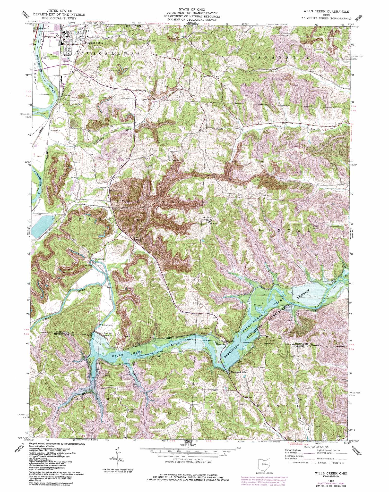
Wills Creek Topo Map Ohio
To zoom in, hover over the map of Wills Creek
USGS Topo Quad 40081b7 - 1:24,000 scale
| Topo Map Name: | Wills Creek |
| USGS Topo Quad ID: | 40081b7 |
| Print Size: | ca. 21 1/4" wide x 27" high |
| Southeast Coordinates: | 40.125° N latitude / 81.75° W longitude |
| Map Center Coordinates: | 40.1875° N latitude / 81.8125° W longitude |
| U.S. State: | OH |
| Filename: | o40081b7.jpg |
| Download Map JPG Image: | Wills Creek topo map 1:24,000 scale |
| Map Type: | Topographic |
| Topo Series: | 7.5´ |
| Map Scale: | 1:24,000 |
| Source of Map Images: | United States Geological Survey (USGS) |
| Alternate Map Versions: |
Wills Creek OH 1962, updated 1963 Download PDF Buy paper map Wills Creek OH 1962, updated 1970 Download PDF Buy paper map Wills Creek OH 1962, updated 1978 Download PDF Buy paper map Wills Creek OH 1962, updated 1985 Download PDF Buy paper map Wills Creek OH 1994, updated 1998 Download PDF Buy paper map Wills Creek OH 2010 Download PDF Buy paper map Wills Creek OH 2013 Download PDF Buy paper map Wills Creek OH 2016 Download PDF Buy paper map |
1:24,000 Topo Quads surrounding Wills Creek
Spring Mountain |
Killbuck |
New Bedford |
Baltic |
Stone Creek |
Warsaw |
Randle |
Coshocton |
Fresno |
Newcomerstown |
Trinway |
Conesville |
Wills Creek |
Plainfield |
Kimbolton |
Dresden |
Adamsville |
Otsego |
Bloomfield |
Cambridge |
Zanesville West |
Zanesville East |
Norwich |
New Concord |
Byesville |
> Back to 40081a1 at 1:100,000 scale
> Back to 40080a1 at 1:250,000 scale
> Back to U.S. Topo Maps home
Wills Creek topo map: Gazetteer
Wills Creek: Bridges
Randle Bridge elevation 224m 734′Wills Creek: Dams
Wills Creek Dam elevation 235m 770′Wills Creek: Populated Places
Bacon elevation 250m 820′Blue Row elevation 249m 816′
Clowville (historical) elevation 226m 741′
Marquand Mills elevation 232m 761′
Maysville elevation 238m 780′
Pleasant Valley elevation 239m 784′
Wills Creek elevation 226m 741′
Wills Creek: Post Offices
Bacon Post Office (historical) elevation 249m 816′Will's Creek Post Office (historical) elevation 234m 767′
Wills Creek: Reservoirs
BSA-Muskingum Valley Council Lake elevation 249m 816′Columbus and Southern Pond 0116-00 elevation 238m 780′
Wills Creek Lake elevation 235m 770′
Wills Creek: Streams
Big Run elevation 229m 751′Brelsford Run elevation 229m 751′
Robinson Run elevation 222m 728′
Rock Run elevation 224m 734′
Wills Creek digital topo map on disk
Buy this Wills Creek topo map showing relief, roads, GPS coordinates and other geographical features, as a high-resolution digital map file on DVD:
 map DVD")