Tippecanoe Topo Map Ohio
To zoom in, hover over the map of Tippecanoe
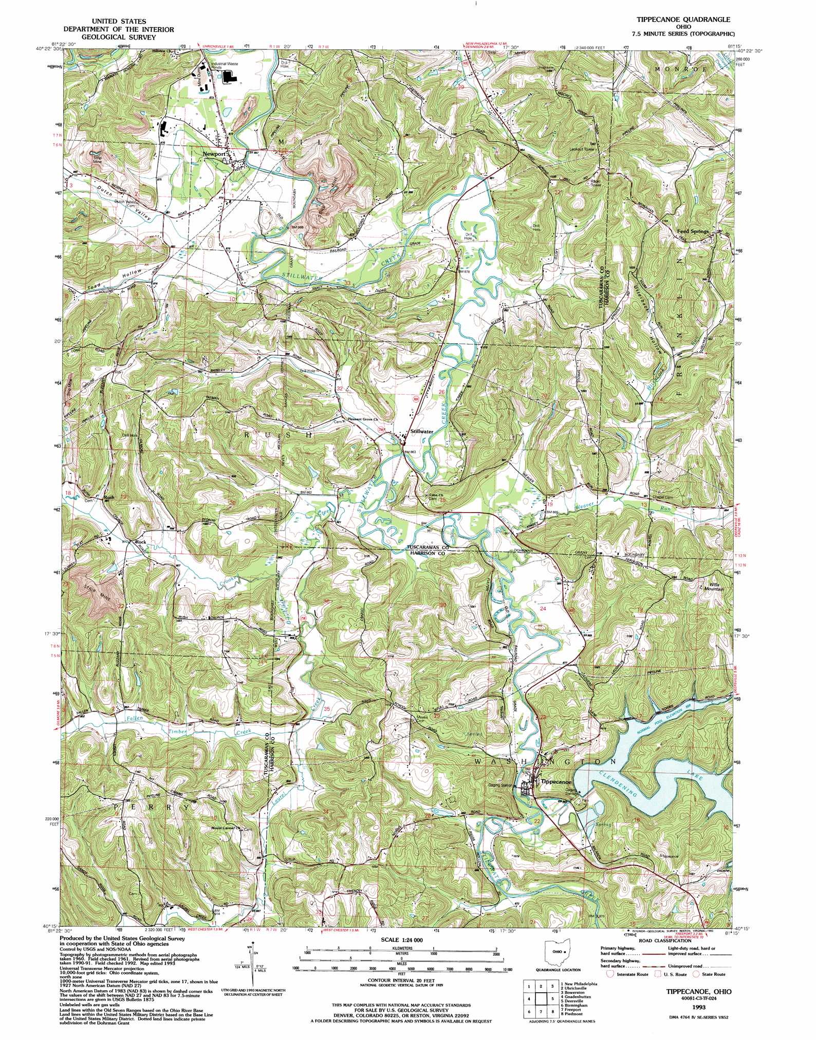
USGS Topo Quad 40081c3 - 1:24,000 scale
| Topo Map Name: | Tippecanoe |
| USGS Topo Quad ID: | 40081c3 |
| Print Size: | ca. 21 1/4" wide x 27" high |
| Southeast Coordinates: | 40.25° N latitude / 81.25° W longitude |
| Map Center Coordinates: | 40.3125° N latitude / 81.3125° W longitude |
| U.S. State: | OH |
| Filename: | o40081c3.jpg |
| Download Map JPG Image: | Tippecanoe topo map 1:24,000 scale |
| Map Type: | Topographic |
| Topo Series: | 7.5´ |
| Map Scale: | 1:24,000 |
| Source of Map Images: | United States Geological Survey (USGS) |
| Alternate Map Versions: |
Tippecanoe OH 1961, updated 1963 Download PDF Buy paper map Tippecanoe OH 1961, updated 1972 Download PDF Buy paper map Tippecanoe OH 1961, updated 1978 Download PDF Buy paper map Tippecanoe OH 1993, updated 1993 Download PDF Buy paper map Tippecanoe OH 1994, updated 1998 Download PDF Buy paper map Tippecanoe OH 2010 Download PDF Buy paper map Tippecanoe OH 2013 Download PDF Buy paper map Tippecanoe OH 2016 Download PDF Buy paper map |
1:24,000 Topo Quads surrounding Tippecanoe
Strasburg |
Dover |
Mineral City |
Dellroy |
Carrollton |
Stone Creek |
New Philadelphia |
Uhrichsville |
Bowerston |
Scio |
Newcomerstown |
Gnadenhutten |
Tippecanoe |
Deersville |
Jewett |
Kimbolton |
Birmingham |
Freeport |
Piedmont |
Flushing |
Cambridge |
Old Washington |
Antrim |
Fairview |
Bethesda |
> Back to 40081a1 at 1:100,000 scale
> Back to 40080a1 at 1:250,000 scale
> Back to U.S. Topo Maps home
Tippecanoe topo map: Gazetteer
Tippecanoe: Bays
Hefling Bay elevation 268m 879′Log Cabin Bay elevation 272m 892′
McConnell Bay elevation 271m 889′
Tippecanoe: Dams
Clendening Dam elevation 266m 872′Tippecanoe: Mines
Crooked Creek Mine elevation 334m 1095′Hitchcock Mine elevation 301m 987′
Tippecanoe Mine elevation 319m 1046′
Tippecanoe: Populated Places
Feed Springs elevation 332m 1089′Newport elevation 263m 862′
Rock elevation 265m 869′
Rush elevation 267m 875′
Stillwater elevation 262m 859′
Tippecanoe elevation 274m 898′
Tippecanoe: Post Offices
Feed Spring Post Office (historical) elevation 332m 1089′Rock Post Office (historical) elevation 275m 902′
Rush Post Office (historical) elevation 268m 879′
Tippecanoe Post Office elevation 265m 869′
Tippecanoe: Reservoirs
Clendening Lake elevation 271m 889′Tippecanoe: Streams
Brushy Fork elevation 262m 859′Crooked Creek elevation 261m 856′
Fallen Timber Creek elevation 262m 859′
Hefling Run elevation 274m 898′
Hitchcock Run elevation 263m 862′
Laurel Creek elevation 258m 846′
Watson Creek elevation 263m 862′
Weaver Run elevation 262m 859′
Tippecanoe: Summits
Wills Mountain elevation 370m 1213′Tippecanoe: Valleys
Dutch Valley elevation 265m 869′Toad Hollow elevation 262m 859′
Utterback Hollow elevation 274m 898′
Tippecanoe digital topo map on disk
Buy this Tippecanoe topo map showing relief, roads, GPS coordinates and other geographical features, as a high-resolution digital map file on DVD:
 map DVD")