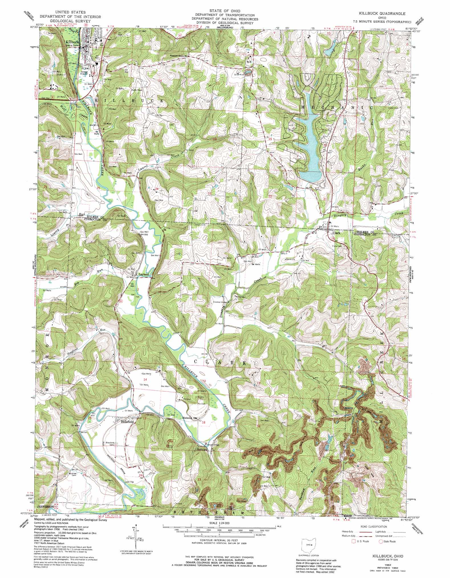
Killbuck Topo Map Ohio
To zoom in, hover over the map of Killbuck
USGS Topo Quad 40081d8 - 1:24,000 scale
| Topo Map Name: | Killbuck |
| USGS Topo Quad ID: | 40081d8 |
| Print Size: | ca. 21 1/4" wide x 27" high |
| Southeast Coordinates: | 40.375° N latitude / 81.875° W longitude |
| Map Center Coordinates: | 40.4375° N latitude / 81.9375° W longitude |
| U.S. State: | OH |
| Filename: | o40081d8.jpg |
| Download Map JPG Image: | Killbuck topo map 1:24,000 scale |
| Map Type: | Topographic |
| Topo Series: | 7.5´ |
| Map Scale: | 1:24,000 |
| Source of Map Images: | United States Geological Survey (USGS) |
| Alternate Map Versions: |
Killbuck OH 1962, updated 1963 Download PDF Buy paper map Killbuck OH 1962, updated 1973 Download PDF Buy paper map Killbuck OH 1962, updated 1978 Download PDF Buy paper map Killbuck OH 1962, updated 1985 Download PDF Buy paper map Killbuck OH 1962, updated 1992 Download PDF Buy paper map Killbuck OH 1994, updated 1998 Download PDF Buy paper map Killbuck OH 2010 Download PDF Buy paper map Killbuck OH 2013 Download PDF Buy paper map Killbuck OH 2016 Download PDF Buy paper map |
1:24,000 Topo Quads surrounding Killbuck
Loudonville |
Shreve |
Holmesville |
Fredericksburg |
Wilmot |
Greer |
Glenmont |
Millersburg |
Berlin |
Sugarcreek |
Brinkhaven |
Spring Mountain |
Killbuck |
New Bedford |
Baltic |
Walhonding |
Warsaw |
Randle |
Coshocton |
Fresno |
Perryton |
Trinway |
Conesville |
Wills Creek |
Plainfield |
> Back to 40081a1 at 1:100,000 scale
> Back to 40080a1 at 1:250,000 scale
> Back to U.S. Topo Maps home
Killbuck topo map: Gazetteer
Killbuck: Bridges
Helmick Bridge elevation 240m 787′Killbuck: Dams
Hickory Lake Dam elevation 302m 990′Lake Buckhorn Dam elevation 252m 826′
Killbuck: Populated Places
Blissfield elevation 251m 823′Clark elevation 254m 833′
Helmick elevation 240m 787′
Killbuck elevation 245m 803′
Layland elevation 243m 797′
Mount Union (historical) elevation 254m 833′
Killbuck: Post Offices
Blissfield Post Office elevation 244m 800′Clark Post Office elevation 254m 833′
Helmick Post Office (historical) elevation 241m 790′
Killbuck Post Office elevation 245m 803′
Layland Post Office (historical) elevation 242m 793′
Killbuck: Reservoirs
Hickory Lake elevation 302m 990′Lake Buckhorn elevation 252m 826′
Killbuck: Streams
Big Run elevation 235m 770′Black Creek elevation 244m 800′
Bucks Run elevation 250m 820′
Doughty Creek elevation 233m 764′
Hoagland Run elevation 238m 780′
Laurel Creek elevation 239m 784′
Lepley Run elevation 240m 787′
Wolf Creek elevation 243m 797′
Killbuck digital topo map on disk
Buy this Killbuck topo map showing relief, roads, GPS coordinates and other geographical features, as a high-resolution digital map file on DVD:
 map DVD")