Navarre Topo Map Ohio
To zoom in, hover over the map of Navarre
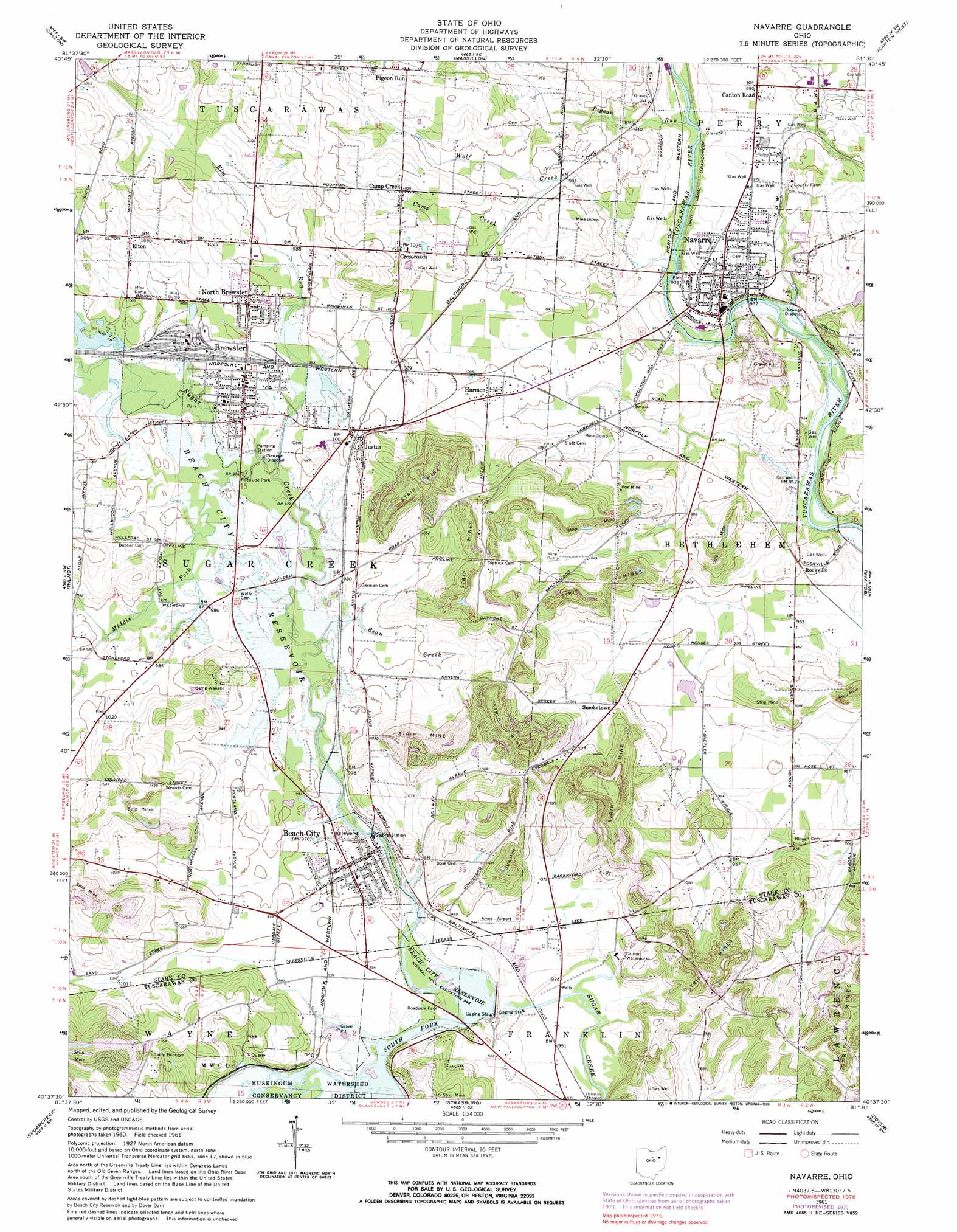
USGS Topo Quad 40081f5 - 1:24,000 scale
| Topo Map Name: | Navarre |
| USGS Topo Quad ID: | 40081f5 |
| Print Size: | ca. 21 1/4" wide x 27" high |
| Southeast Coordinates: | 40.625° N latitude / 81.5° W longitude |
| Map Center Coordinates: | 40.6875° N latitude / 81.5625° W longitude |
| U.S. State: | OH |
| Filename: | o40081f5.jpg |
| Download Map JPG Image: | Navarre topo map 1:24,000 scale |
| Map Type: | Topographic |
| Topo Series: | 7.5´ |
| Map Scale: | 1:24,000 |
| Source of Map Images: | United States Geological Survey (USGS) |
| Alternate Map Versions: |
Navarre OH 1961, updated 1963 Download PDF Buy paper map Navarre OH 1961, updated 1970 Download PDF Buy paper map Navarre OH 1961, updated 1972 Download PDF Buy paper map Navarre OH 1961, updated 1983 Download PDF Buy paper map Navarre OH 1961, updated 1990 Download PDF Buy paper map Navarre OH 1994, updated 1998 Download PDF Buy paper map Navarre OH 2010 Download PDF Buy paper map Navarre OH 2013 Download PDF Buy paper map Navarre OH 2016 Download PDF Buy paper map |
1:24,000 Topo Quads surrounding Navarre
Rittman |
Doylestown |
Canal Fulton |
North Canton |
Hartville |
Orrville |
Dalton |
Massillon |
Canton West |
Canton East |
Fredericksburg |
Wilmot |
Navarre |
Bolivar |
Waynesburg |
Berlin |
Sugarcreek |
Strasburg |
Dover |
Mineral City |
New Bedford |
Baltic |
Stone Creek |
New Philadelphia |
Uhrichsville |
> Back to 40081e1 at 1:100,000 scale
> Back to 40080a1 at 1:250,000 scale
> Back to U.S. Topo Maps home
Navarre topo map: Gazetteer
Navarre: Airports
Beach City Airport elevation 297m 974′Navarre: Dams
Beach City Dam elevation 293m 961′Navarre: Falls
Sugar Creek Falls (historical) elevation 291m 954′Navarre: Mines
Fox Mine elevation 313m 1026′Tiger Mine elevation 317m 1040′
Navarre: Parks
Beach City Wildlife Area elevation 319m 1046′Navarre-Bethlehem Park elevation 279m 915′
Navarre: Populated Places
Beach City elevation 305m 1000′Brewster elevation 303m 994′
Brewster Estates Mobile Home Park elevation 298m 977′
Camp Creek elevation 317m 1040′
Canton Road elevation 298m 977′
Crossroads elevation 331m 1085′
Deardoffs Mills (historical) elevation 291m 954′
Elton elevation 321m 1053′
Harmon elevation 310m 1017′
Hillview Mobile Court elevation 305m 1000′
Justus elevation 309m 1013′
Mapleview Mobile Home Manor elevation 294m 964′
Navarre elevation 292m 958′
Navarre Village elevation 299m 980′
North Brewster elevation 317m 1040′
Park Heights elevation 303m 994′
Pigeon Run elevation 329m 1079′
Plainsburg (historical) elevation 316m 1036′
Rockville elevation 305m 1000′
Smoketown elevation 319m 1046′
Tarrymore elevation 296m 971′
Navarre: Post Offices
Beach City Post Office elevation 305m 1000′Brewster Post Office elevation 304m 997′
Elton Post Office (historical) elevation 321m 1053′
Justus Post Office (historical) elevation 310m 1017′
Navarre Post Office elevation 294m 964′
Pigeonrun Post Office (historical) elevation 329m 1079′
Navarre: Reservoirs
Beach City Lake elevation 293m 961′Navarre: Streams
Bean Creek elevation 292m 958′Camp Creek elevation 298m 977′
Elm Run elevation 292m 958′
Middle Fork Sugar Creek elevation 296m 971′
Pigeon Run elevation 280m 918′
South Fork Sugar Creek elevation 292m 958′
Wolf Creek elevation 280m 918′
Navarre: Summits
Weimers Hill elevation 353m 1158′Navarre digital topo map on disk
Buy this Navarre topo map showing relief, roads, GPS coordinates and other geographical features, as a high-resolution digital map file on DVD:
 map DVD")