North Canton Topo Map Ohio
To zoom in, hover over the map of North Canton
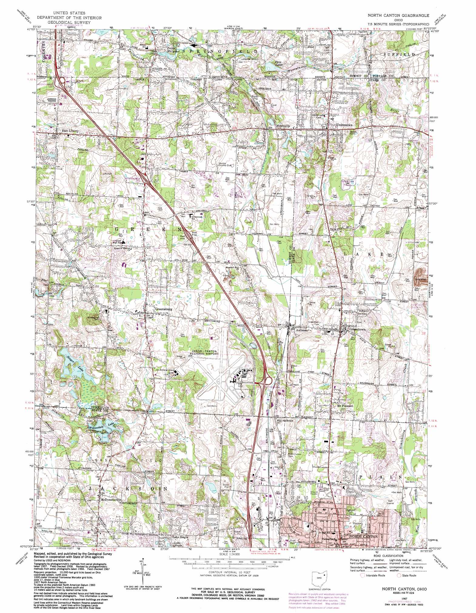
USGS Topo Quad 40081h4 - 1:24,000 scale
| Topo Map Name: | North Canton |
| USGS Topo Quad ID: | 40081h4 |
| Print Size: | ca. 21 1/4" wide x 27" high |
| Southeast Coordinates: | 40.875° N latitude / 81.375° W longitude |
| Map Center Coordinates: | 40.9375° N latitude / 81.4375° W longitude |
| U.S. State: | OH |
| Filename: | o40081h4.jpg |
| Download Map JPG Image: | North Canton topo map 1:24,000 scale |
| Map Type: | Topographic |
| Topo Series: | 7.5´ |
| Map Scale: | 1:24,000 |
| Source of Map Images: | United States Geological Survey (USGS) |
| Alternate Map Versions: |
North Canton OH 1958, updated 1959 Download PDF Buy paper map North Canton OH 1967, updated 1970 Download PDF Buy paper map North Canton OH 1967, updated 1978 Download PDF Buy paper map North Canton OH 1967, updated 1984 Download PDF Buy paper map North Canton OH 1994, updated 1997 Download PDF Buy paper map North Canton OH 2010 Download PDF Buy paper map North Canton OH 2013 Download PDF Buy paper map North Canton OH 2016 Download PDF Buy paper map |
1:24,000 Topo Quads surrounding North Canton
West Richfield |
Peninsula |
Hudson |
Kent |
Ravenna |
Wadsworth |
Akron West |
Akron East |
Suffield |
Atwater |
Doylestown |
Canal Fulton |
North Canton |
Hartville |
Limaville |
Dalton |
Massillon |
Canton West |
Canton East |
Robertsville |
Wilmot |
Navarre |
Bolivar |
Waynesburg |
Malvern |
> Back to 40081e1 at 1:100,000 scale
> Back to 40080a1 at 1:250,000 scale
> Back to U.S. Topo Maps home
North Canton topo map: Gazetteer
North Canton: Airports
Akron-Canton Regional Airport elevation 367m 1204′Mayfield Airport elevation 332m 1089′
North Canton: Crossings
Interchange 111 elevation 328m 1076′Interchange 113 elevation 346m 1135′
Interchange 118 elevation 364m 1194′
Interchange 120 elevation 323m 1059′
North Canton: Dams
Willowdale Lake Dam elevation 324m 1062′North Canton: Lakes
Lake Slagle elevation 343m 1125′Pine Lake elevation 329m 1079′
Singer Lake elevation 328m 1076′
Tritts Millpond elevation 320m 1049′
Willowdale Lake elevation 324m 1062′
North Canton: Parks
Clearwater Park elevation 344m 1128′Dogwood Park elevation 350m 1148′
Greentown Park elevation 353m 1158′
Memorial Stadium elevation 355m 1164′
Millside Park elevation 360m 1181′
Pebble Creek Reserve elevation 345m 1131′
Price Park elevation 324m 1062′
Uniontown Park elevation 338m 1108′
North Canton: Populated Places
Aultman elevation 336m 1102′Avon Mobile Home Park elevation 372m 1220′
East Liberty elevation 332m 1089′
Evergreen Mobile Park elevation 350m 1148′
Green elevation 347m 1138′
Greensburg elevation 359m 1177′
Greentown elevation 366m 1200′
Lake Slagle elevation 347m 1138′
Maces Mobile Estates elevation 340m 1115′
Marchand (historical) elevation 328m 1076′
Mayfield Mobile Home Park elevation 347m 1138′
McDonaldsville elevation 361m 1184′
Millheim elevation 329m 1079′
Mount Pleasant elevation 368m 1207′
Myersville elevation 329m 1079′
North Canton elevation 354m 1161′
Royal Mobile Park elevation 346m 1135′
Tower Terrace elevation 354m 1161′
Uniontown elevation 341m 1118′
North Canton: Post Offices
Aultman Post Office (historical) elevation 335m 1099′Greensburg Post Office elevation 359m 1177′
Greentown Post Office elevation 366m 1200′
Marchand Post Office (historical) elevation 327m 1072′
McDonaldsville Post Office (historical) elevation 360m 1181′
Millheim Post Office (historical) elevation 328m 1076′
Myersville Post Office (historical) elevation 330m 1082′
North Canton Post Office elevation 350m 1148′
North Canton Post Office (historical) elevation 350m 1148′
Uniontown Post Office elevation 341m 1118′
North Canton digital topo map on disk
Buy this North Canton topo map showing relief, roads, GPS coordinates and other geographical features, as a high-resolution digital map file on DVD:
 map DVD")