Canal Fulton Topo Map Ohio
To zoom in, hover over the map of Canal Fulton
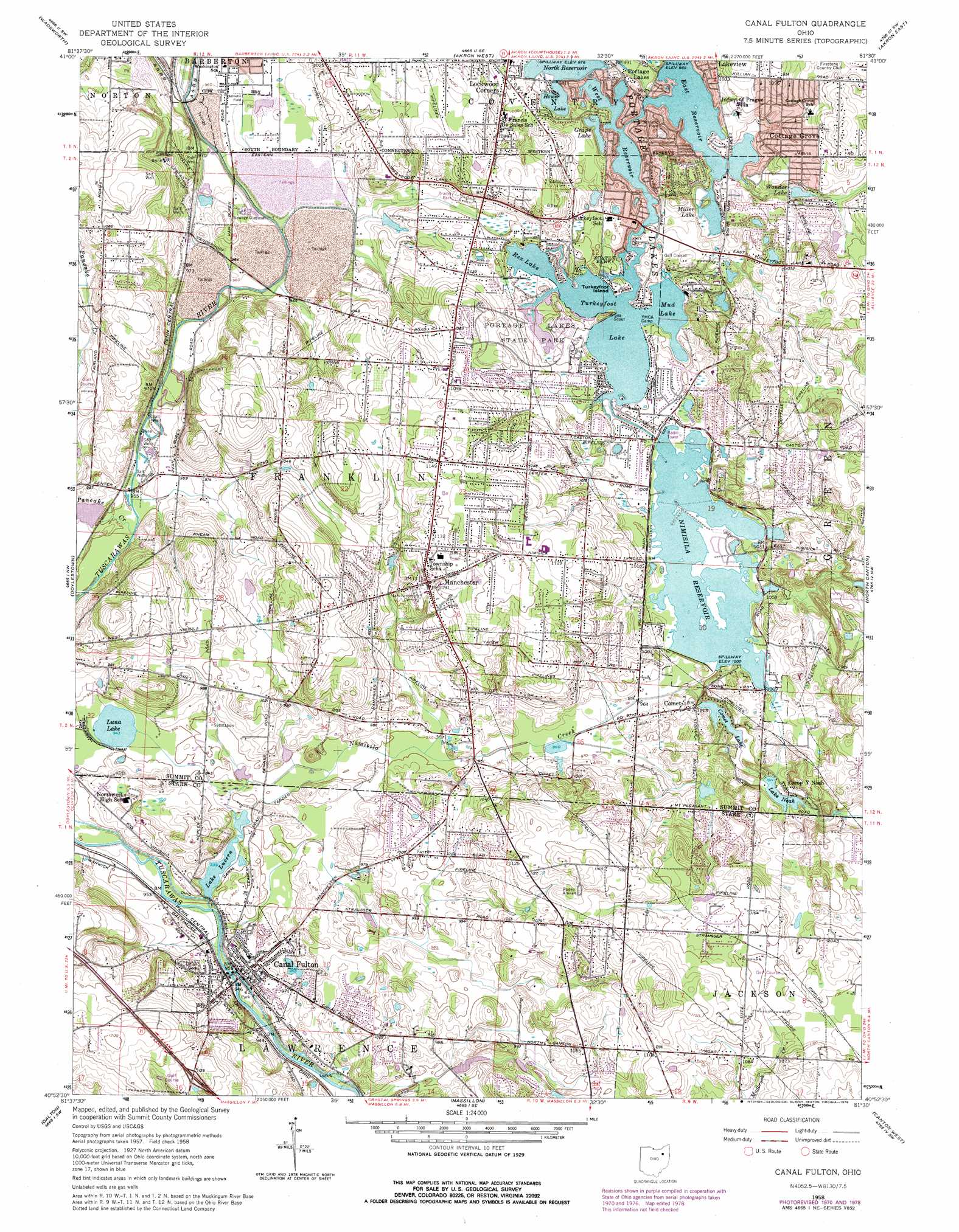
USGS Topo Quad 40081h5 - 1:24,000 scale
| Topo Map Name: | Canal Fulton |
| USGS Topo Quad ID: | 40081h5 |
| Print Size: | ca. 21 1/4" wide x 27" high |
| Southeast Coordinates: | 40.875° N latitude / 81.5° W longitude |
| Map Center Coordinates: | 40.9375° N latitude / 81.5625° W longitude |
| U.S. State: | OH |
| Filename: | o40081h5.jpg |
| Download Map JPG Image: | Canal Fulton topo map 1:24,000 scale |
| Map Type: | Topographic |
| Topo Series: | 7.5´ |
| Map Scale: | 1:24,000 |
| Source of Map Images: | United States Geological Survey (USGS) |
| Alternate Map Versions: |
Canal Fulton OH 1958, updated 1959 Download PDF Buy paper map Canal Fulton OH 1958, updated 1969 Download PDF Buy paper map Canal Fulton OH 1958, updated 1971 Download PDF Buy paper map Canal Fulton OH 1958, updated 1978 Download PDF Buy paper map Canal Fulton OH 1994, updated 1997 Download PDF Buy paper map Canal Fulton OH 2010 Download PDF Buy paper map Canal Fulton OH 2013 Download PDF Buy paper map Canal Fulton OH 2016 Download PDF Buy paper map |
1:24,000 Topo Quads surrounding Canal Fulton
Medina |
West Richfield |
Peninsula |
Hudson |
Kent |
Seville |
Wadsworth |
Akron West |
Akron East |
Suffield |
Rittman |
Doylestown |
Canal Fulton |
North Canton |
Hartville |
Orrville |
Dalton |
Massillon |
Canton West |
Canton East |
Fredericksburg |
Wilmot |
Navarre |
Bolivar |
Waynesburg |
> Back to 40081e1 at 1:100,000 scale
> Back to 40080a1 at 1:250,000 scale
> Back to U.S. Topo Maps home
Canal Fulton topo map: Gazetteer
Canal Fulton: Airports
Canal Fulton Airport elevation 346m 1135′Canal Fulton: Bays
Latham Bay elevation 302m 990′Canal Fulton: Beaches
Turkeyfoot Beach elevation 301m 987′Canal Fulton: Canals
Canal Feeder elevation 285m 935′Canal Fulton: Dams
Comet Lake Dam elevation 299m 980′Lake Lucern Dam elevation 286m 938′
Lake Noah Dam elevation 308m 1010′
Ohnoname 10 Dam elevation 294m 964′
Pancake Lake Dam elevation 292m 958′
West Reservoir Dam elevation 299m 980′
Canal Fulton: Islands
Turkeyfoot Island elevation 307m 1007′Canal Fulton: Lakes
Grape Lake elevation 301m 987′Hower Lake elevation 296m 971′
Lake Noah elevation 305m 1000′
Luna Lake elevation 287m 941′
Miller Lake elevation 302m 990′
Mud Lake elevation 298m 977′
Portage Lakes elevation 300m 984′
Rex Lake elevation 299m 980′
Turkeyfoot Lake elevation 300m 984′
Wonder Lake elevation 311m 1020′
Canal Fulton: Parks
Canal Fulton Historic District elevation 290m 951′Elson Park elevation 292m 958′
Portage Lakes State Park elevation 313m 1026′
Portage Lakes Wetland State Nature Preserve elevation 295m 967′
Canal Fulton: Populated Places
Brimestone Corners (historical) elevation 338m 1108′Canal Fulton elevation 290m 951′
Comet elevation 302m 990′
Comet Trailer Park elevation 301m 987′
Cottage Grove elevation 321m 1053′
Infant of Prague Villa elevation 313m 1026′
Lakeview elevation 314m 1030′
Lockwood Corners elevation 305m 1000′
Manchester elevation 334m 1095′
New Franklin elevation 333m 1092′
Nimisila Mobile Home Park elevation 314m 1030′
Rex Hill Mobile Home Park elevation 308m 1010′
Sandy Beach Trailer Park elevation 312m 1023′
West Fulton elevation 297m 974′
Canal Fulton: Post Offices
Canal Fulton Post Office elevation 291m 954′Comet Post Office (historical) elevation 305m 1000′
Canal Fulton: Reservoirs
Comet Lake elevation 299m 980′Cottage Grove Lake elevation 302m 990′
Lake Lucern elevation 286m 938′
Nimisila Reservoir elevation 301m 987′
Ohnoname 10 Reservoir elevation 294m 964′
Pancake Lake elevation 292m 958′
West Reservoir elevation 299m 980′
Canal Fulton: Streams
Nimisila Creek elevation 286m 938′Pancake Creek elevation 288m 944′
Canal Fulton digital topo map on disk
Buy this Canal Fulton topo map showing relief, roads, GPS coordinates and other geographical features, as a high-resolution digital map file on DVD:
 map DVD")