Galena Topo Map Ohio
To zoom in, hover over the map of Galena
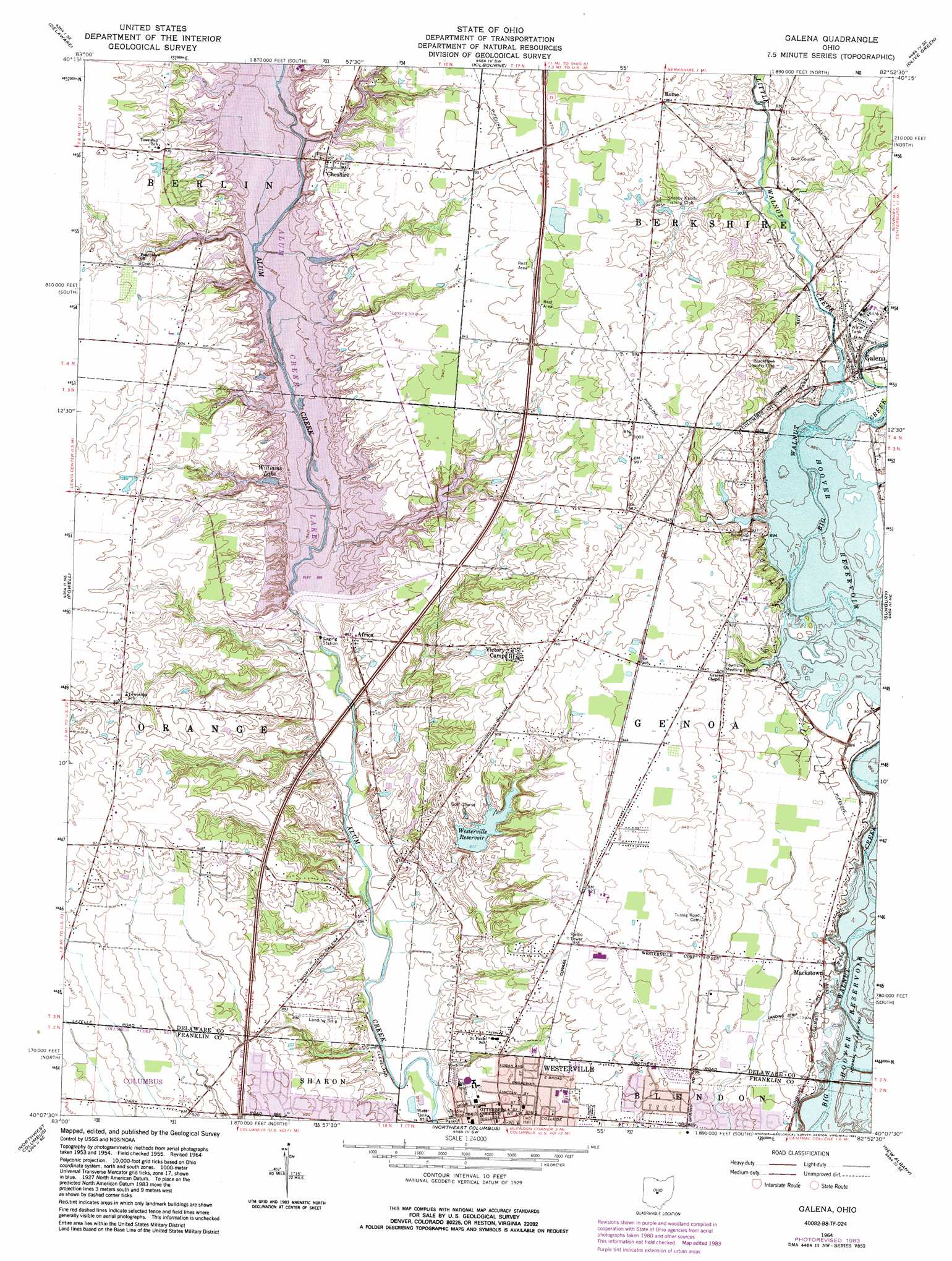
USGS Topo Quad 40082b8 - 1:24,000 scale
| Topo Map Name: | Galena |
| USGS Topo Quad ID: | 40082b8 |
| Print Size: | ca. 21 1/4" wide x 27" high |
| Southeast Coordinates: | 40.125° N latitude / 82.875° W longitude |
| Map Center Coordinates: | 40.1875° N latitude / 82.9375° W longitude |
| U.S. State: | OH |
| Filename: | o40082b8.jpg |
| Download Map JPG Image: | Galena topo map 1:24,000 scale |
| Map Type: | Topographic |
| Topo Series: | 7.5´ |
| Map Scale: | 1:24,000 |
| Source of Map Images: | United States Geological Survey (USGS) |
| Alternate Map Versions: |
Galena OH 1955, updated 1956 Download PDF Buy paper map Galena OH 1964, updated 1965 Download PDF Buy paper map Galena OH 1964, updated 1975 Download PDF Buy paper map Galena OH 1964, updated 1983 Download PDF Buy paper map Galena OH 1964, updated 1983 Download PDF Buy paper map Galena OH 1995, updated 1999 Download PDF Buy paper map Galena OH 2010 Download PDF Buy paper map Galena OH 2013 Download PDF Buy paper map Galena OH 2016 Download PDF Buy paper map |
1:24,000 Topo Quads surrounding Galena
Prospect |
Waldo |
Ashley |
Marengo |
Chesterville |
Ostrander |
Delaware |
Kilbourne |
Olive Green |
Centerburg |
Shawnee Hills |
Powell |
Galena |
Sunbury |
Johnstown |
Hilliard |
Northwest Columbus |
Northeast Columbus |
New Albany |
Jersey |
Galloway |
Southwest Columbus |
Southeast Columbus |
Reynoldsburg |
Pataskala |
> Back to 40082a1 at 1:100,000 scale
> Back to 40082a1 at 1:250,000 scale
> Back to U.S. Topo Maps home
Galena topo map: Gazetteer
Galena: Airports
Grover Airport elevation 286m 938′Pine Lake Airport elevation 296m 971′
Galena: Dams
Alum Creek Lake Dam elevation 254m 833′Berkshire Lake Dam elevation 289m 948′
Pomeroy Ponds Dam elevation 285m 935′
Westerville Reservoir Dam elevation 268m 879′
Galena: Parks
Alum Creek Park North elevation 253m 830′Alum Creek State Park elevation 274m 898′
Hanby Park elevation 265m 869′
Heritage Park elevation 246m 807′
Memorial Stadium elevation 261m 856′
Metzger Park elevation 259m 849′
Towers Park elevation 275m 902′
Galena: Populated Places
Africa elevation 264m 866′Cheshire elevation 274m 898′
Galena elevation 281m 921′
Mackstown elevation 277m 908′
Rome elevation 294m 964′
Victory Camp elevation 294m 964′
Westerville elevation 265m 869′
Galena: Post Offices
Africa Post Office (historical) elevation 263m 862′Galena Post Office elevation 280m 918′
Westerville Post Office elevation 265m 869′
Galena: Reservoirs
Alum Creek Lake elevation 254m 833′Berkshire Lake elevation 290m 951′
Pomeroy Ponds elevation 285m 935′
Westerville Reservoir elevation 268m 879′
Williams Lake elevation 261m 856′
Galena: Streams
Big Run elevation 262m 859′Little Walnut Creek elevation 272m 892′
Galena digital topo map on disk
Buy this Galena topo map showing relief, roads, GPS coordinates and other geographical features, as a high-resolution digital map file on DVD:
 map DVD")