Hunt Topo Map Ohio
To zoom in, hover over the map of Hunt
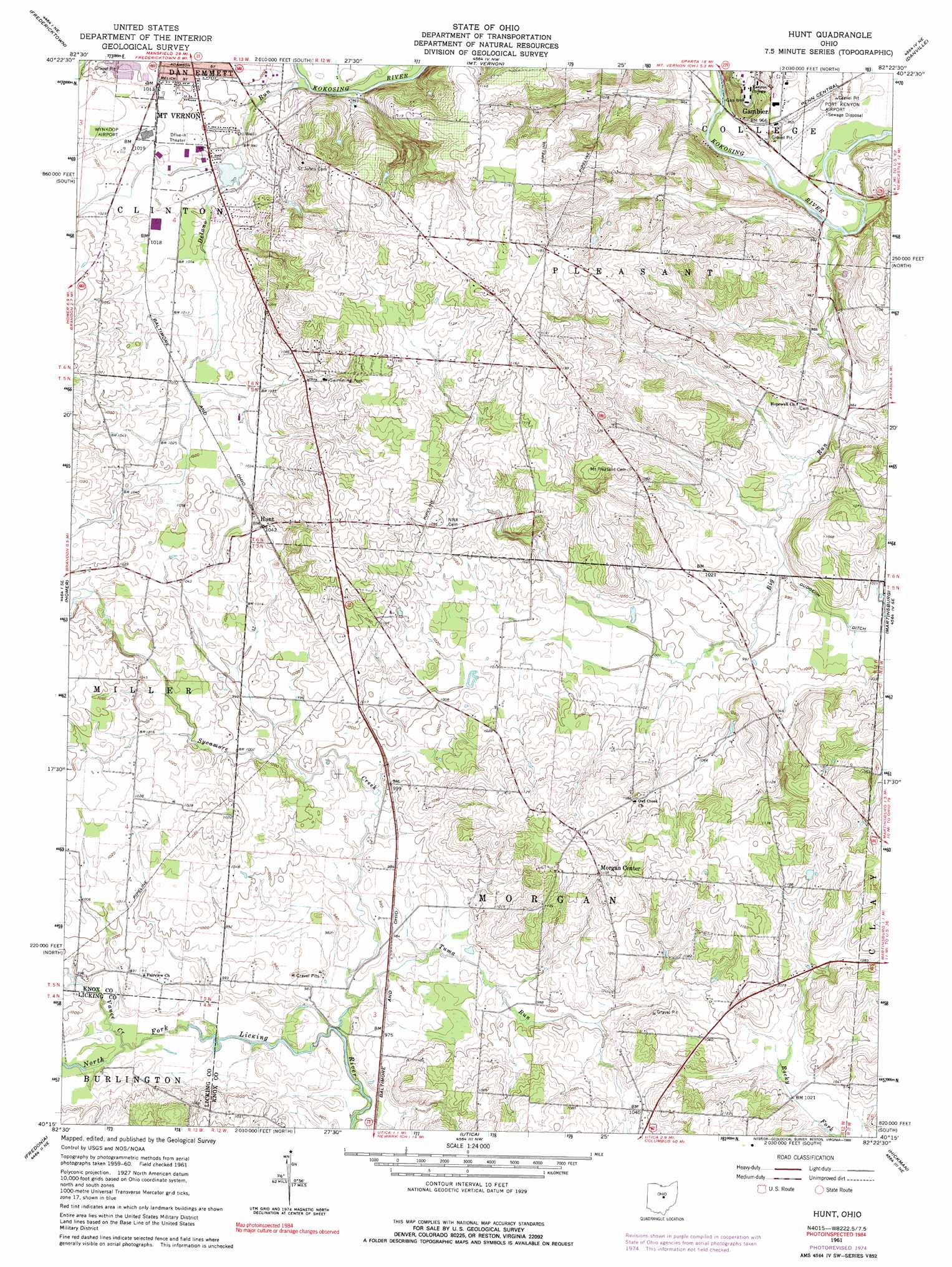
USGS Topo Quad 40082c4 - 1:24,000 scale
| Topo Map Name: | Hunt |
| USGS Topo Quad ID: | 40082c4 |
| Print Size: | ca. 21 1/4" wide x 27" high |
| Southeast Coordinates: | 40.25° N latitude / 82.375° W longitude |
| Map Center Coordinates: | 40.3125° N latitude / 82.4375° W longitude |
| U.S. State: | OH |
| Filename: | o40082c4.jpg |
| Download Map JPG Image: | Hunt topo map 1:24,000 scale |
| Map Type: | Topographic |
| Topo Series: | 7.5´ |
| Map Scale: | 1:24,000 |
| Source of Map Images: | United States Geological Survey (USGS) |
| Alternate Map Versions: |
Hunt OH 1961, updated 1962 Download PDF Buy paper map Hunt OH 1961, updated 1970 Download PDF Buy paper map Hunt OH 1961, updated 1975 Download PDF Buy paper map Hunt OH 1961, updated 1990 Download PDF Buy paper map Hunt OH 2010 Download PDF Buy paper map Hunt OH 2013 Download PDF Buy paper map Hunt OH 2016 Download PDF Buy paper map |
1:24,000 Topo Quads surrounding Hunt
Shauck |
Bellville |
Butler |
Jelloway |
Greer |
Chesterville |
Fredericktown |
Mount Vernon |
Danville |
Brinkhaven |
Centerburg |
Homer |
Hunt |
Martinsburg |
Walhonding |
Johnstown |
Fredonia |
Utica |
Hickman |
Perryton |
Jersey |
Granville |
Newark |
Hanover |
Toboso |
> Back to 40082a1 at 1:100,000 scale
> Back to 40082a1 at 1:250,000 scale
> Back to U.S. Topo Maps home
Hunt topo map: Gazetteer
Hunt: Airports
Port Kenyon Airport elevation 291m 954′Wynkoop Airport elevation 308m 1010′
Hunt: Parks
Baars Tennis Courts elevation 292m 958′McBride Field elevation 295m 967′
Hunt: Populated Places
Hunt elevation 317m 1040′Morgan Center elevation 341m 1118′
Hunt: Post Offices
Hunt Post Office (historical) elevation 315m 1033′Morgan Center Post Office (historical) elevation 338m 1108′
Hunt: Streams
Big Run elevation 283m 928′Chambers Creek elevation 305m 1000′
Delano Run elevation 293m 961′
Muckshaw Run elevation 297m 974′
Owl Creek Stream elevation 298m 977′
Sycamore Creek elevation 292m 958′
Tuma Run elevation 292m 958′
Vance Creek elevation 292m 958′
Hunt digital topo map on disk
Buy this Hunt topo map showing relief, roads, GPS coordinates and other geographical features, as a high-resolution digital map file on DVD:
 map DVD")