Centerburg Topo Map Ohio
To zoom in, hover over the map of Centerburg
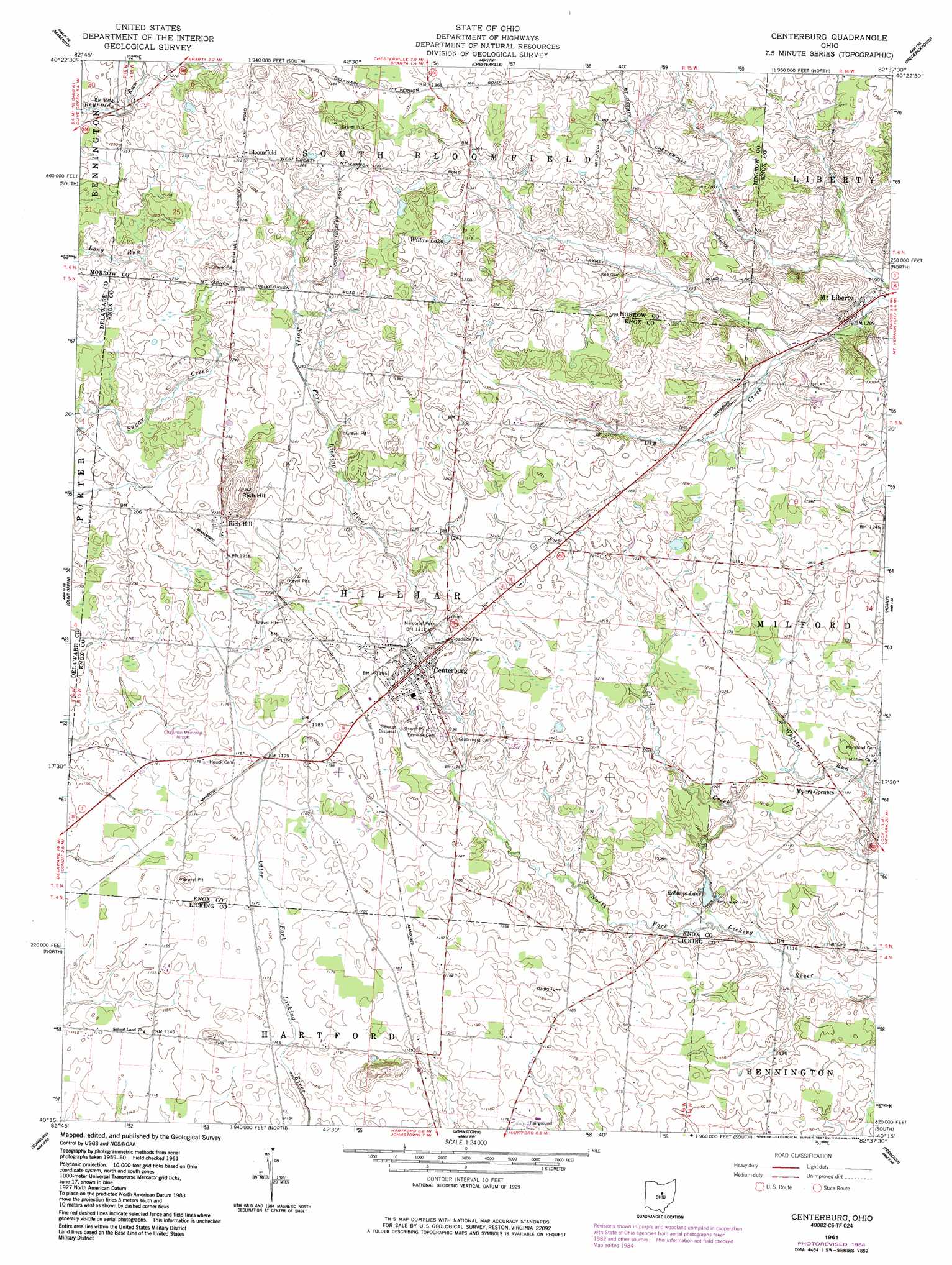
USGS Topo Quad 40082c6 - 1:24,000 scale
| Topo Map Name: | Centerburg |
| USGS Topo Quad ID: | 40082c6 |
| Print Size: | ca. 21 1/4" wide x 27" high |
| Southeast Coordinates: | 40.25° N latitude / 82.625° W longitude |
| Map Center Coordinates: | 40.3125° N latitude / 82.6875° W longitude |
| U.S. State: | OH |
| Filename: | o40082c6.jpg |
| Download Map JPG Image: | Centerburg topo map 1:24,000 scale |
| Map Type: | Topographic |
| Topo Series: | 7.5´ |
| Map Scale: | 1:24,000 |
| Source of Map Images: | United States Geological Survey (USGS) |
| Alternate Map Versions: |
Centerburg OH 1961, updated 1962 Download PDF Buy paper map Centerburg OH 1961, updated 1984 Download PDF Buy paper map Centerburg OH 1961, updated 1984 Download PDF Buy paper map Centerburg OH 2010 Download PDF Buy paper map Centerburg OH 2013 Download PDF Buy paper map Centerburg OH 2016 Download PDF Buy paper map |
1:24,000 Topo Quads surrounding Centerburg
Denmark |
Mount Gilead |
Shauck |
Bellville |
Butler |
Ashley |
Marengo |
Chesterville |
Fredericktown |
Mount Vernon |
Kilbourne |
Olive Green |
Centerburg |
Homer |
Hunt |
Galena |
Sunbury |
Johnstown |
Fredonia |
Utica |
Northeast Columbus |
New Albany |
Jersey |
Granville |
Newark |
> Back to 40082a1 at 1:100,000 scale
> Back to 40082a1 at 1:250,000 scale
> Back to U.S. Topo Maps home
Centerburg topo map: Gazetteer
Centerburg: Airports
Chapman Memorial Field elevation 357m 1171′Centerburg: Lakes
Willow Lake elevation 410m 1345′Centerburg: Parks
Memorial Park elevation 365m 1197′Centerburg: Populated Places
Bloomfield elevation 399m 1309′Centerburg elevation 372m 1220′
Hedington Corners elevation 366m 1200′
Mount Liberty elevation 370m 1213′
Myers Corners elevation 365m 1197′
Rich Hill elevation 375m 1230′
Centerburg: Post Offices
Bloomfield Post Office (historical) elevation 399m 1309′Centerburg Post Office elevation 372m 1220′
Mount Liberty Post Office elevation 372m 1220′
Rich Hill Post Office (historical) elevation 375m 1230′
Centerburg: Streams
Ford Creek elevation 341m 1118′Centerburg: Summits
Rich Hill elevation 414m 1358′Centerburg digital topo map on disk
Buy this Centerburg topo map showing relief, roads, GPS coordinates and other geographical features, as a high-resolution digital map file on DVD:
 map DVD")