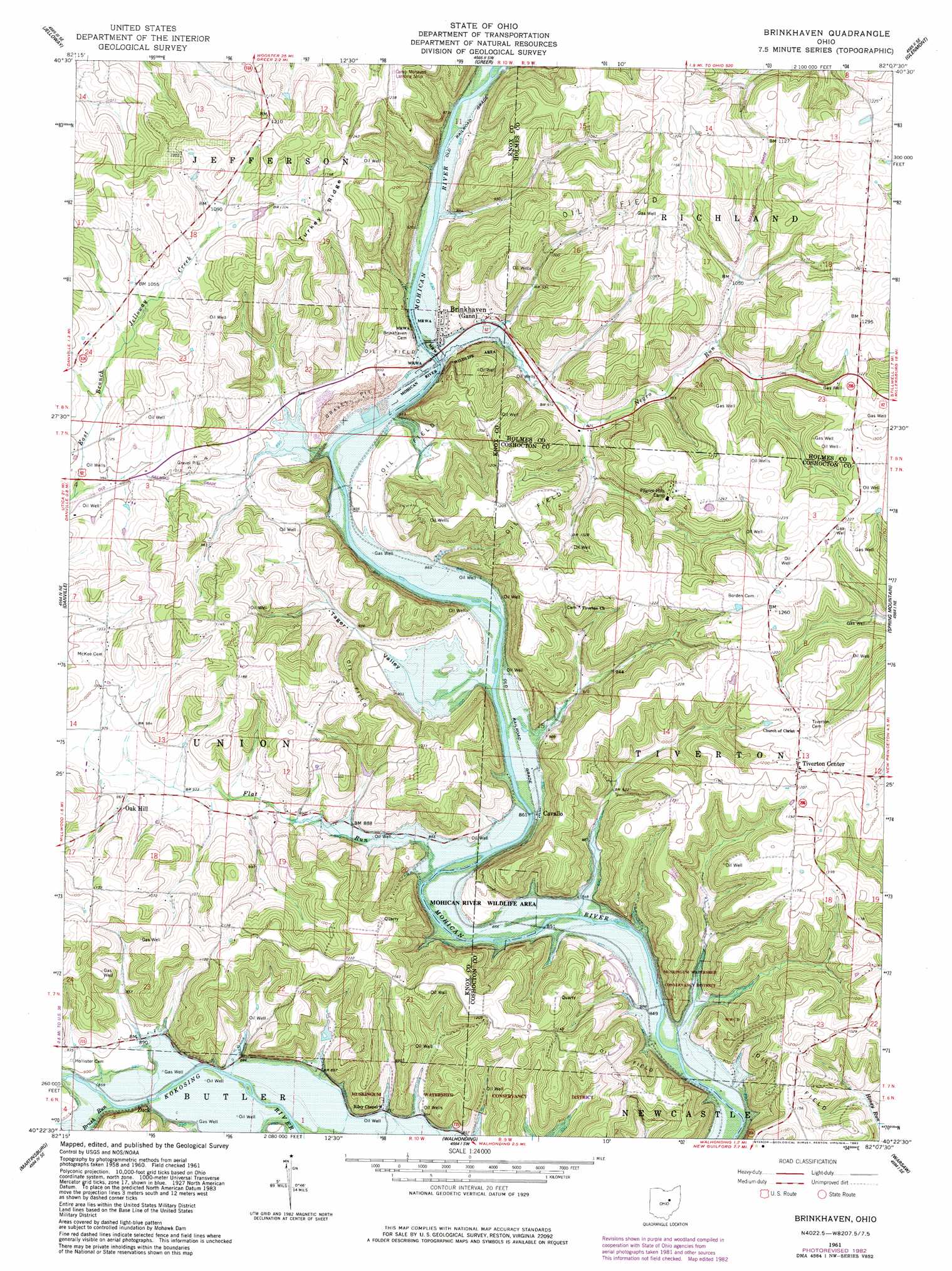
Brinkhaven Topo Map Ohio
To zoom in, hover over the map of Brinkhaven
USGS Topo Quad 40082d2 - 1:24,000 scale
| Topo Map Name: | Brinkhaven |
| USGS Topo Quad ID: | 40082d2 |
| Print Size: | ca. 21 1/4" wide x 27" high |
| Southeast Coordinates: | 40.375° N latitude / 82.125° W longitude |
| Map Center Coordinates: | 40.4375° N latitude / 82.1875° W longitude |
| U.S. State: | OH |
| Filename: | o40082d2.jpg |
| Download Map JPG Image: | Brinkhaven topo map 1:24,000 scale |
| Map Type: | Topographic |
| Topo Series: | 7.5´ |
| Map Scale: | 1:24,000 |
| Source of Map Images: | United States Geological Survey (USGS) |
| Alternate Map Versions: |
Brinkhaven OH 1961, updated 1963 Download PDF Buy paper map Brinkhaven OH 1961, updated 1970 Download PDF Buy paper map Brinkhaven OH 1961, updated 1978 Download PDF Buy paper map Brinkhaven OH 2010 Download PDF Buy paper map Brinkhaven OH 2013 Download PDF Buy paper map Brinkhaven OH 2016 Download PDF Buy paper map |
1:24,000 Topo Quads surrounding Brinkhaven
Lucas |
Perrysville |
Loudonville |
Shreve |
Holmesville |
Butler |
Jelloway |
Greer |
Glenmont |
Millersburg |
Mount Vernon |
Danville |
Brinkhaven |
Spring Mountain |
Killbuck |
Hunt |
Martinsburg |
Walhonding |
Warsaw |
Randle |
Utica |
Hickman |
Perryton |
Trinway |
Conesville |
> Back to 40082a1 at 1:100,000 scale
> Back to 40082a1 at 1:250,000 scale
> Back to U.S. Topo Maps home
Brinkhaven topo map: Gazetteer
Brinkhaven: Airports
Camp Mohaven Landing Strip elevation 385m 1263′Brinkhaven: Parks
Mohican River Wildlife Area elevation 320m 1049′Brinkhaven: Populated Places
Baddow Pass (historical) elevation 338m 1108′Brinkhaven elevation 275m 902′
Cavallo elevation 268m 879′
Hollisters (historical) elevation 281m 921′
Oak Hill elevation 294m 964′
Tiverton Center elevation 371m 1217′
Umbria (historical) elevation 258m 846′
Zuck elevation 262m 859′
Brinkhaven: Post Offices
Baddow Pass Post Office (historical) elevation 342m 1122′Brinkhaven Post Office elevation 272m 892′
Tiverton Post Office (historical) elevation 372m 1220′
Zuck Post Office (historical) elevation 265m 869′
Brinkhaven: Ridges
Turkey Ridge elevation 377m 1236′Yankee Ridge elevation 378m 1240′
Brinkhaven: Streams
Brush Run elevation 262m 859′Flat Run elevation 260m 853′
Negro Run elevation 260m 853′
Spoon River elevation 248m 813′
Brinkhaven: Valleys
Tager Valley elevation 262m 859′Brinkhaven digital topo map on disk
Buy this Brinkhaven topo map showing relief, roads, GPS coordinates and other geographical features, as a high-resolution digital map file on DVD:
 map DVD")