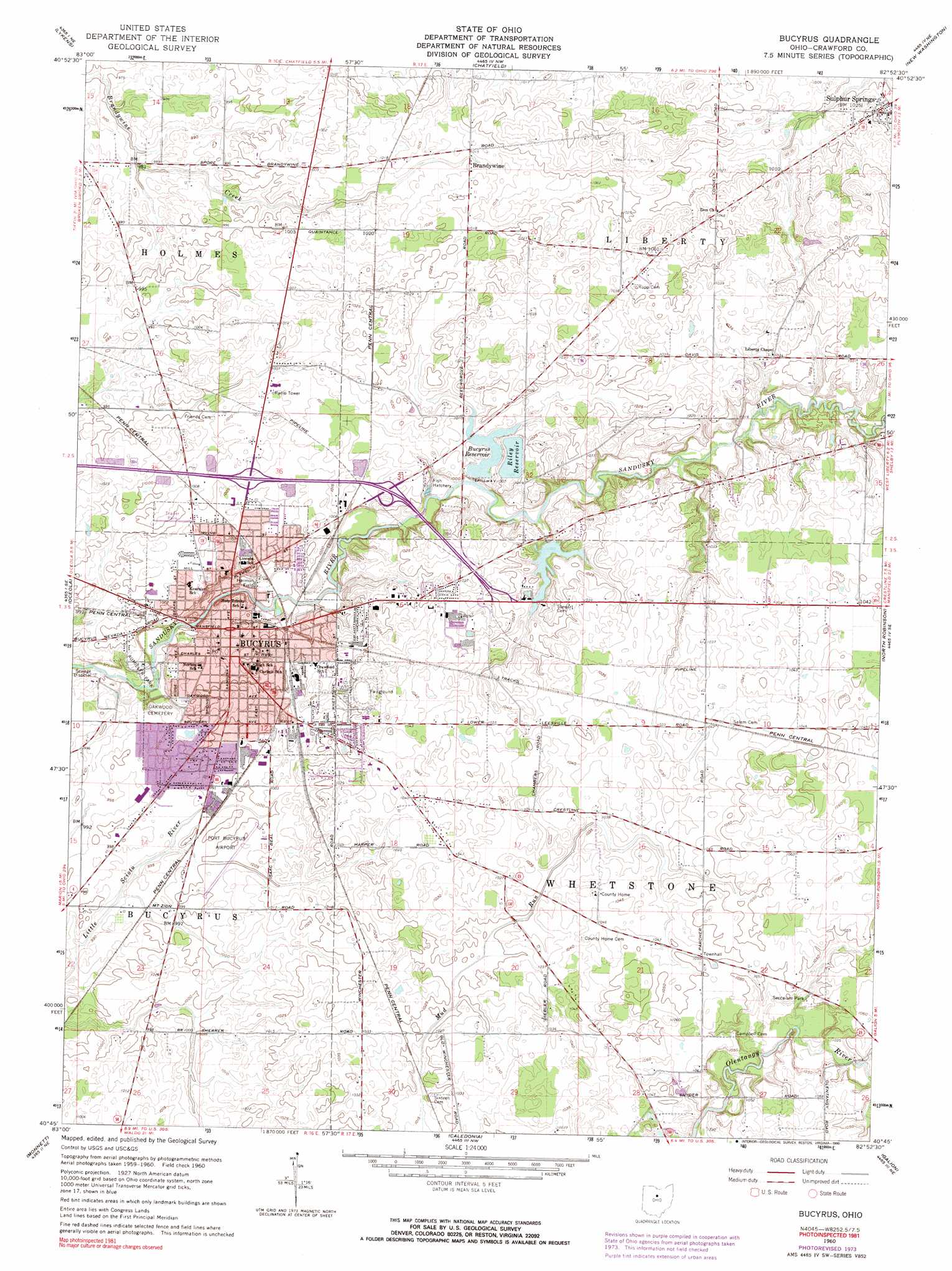
Bucyrus Topo Map Ohio
To zoom in, hover over the map of Bucyrus
USGS Topo Quad 40082g8 - 1:24,000 scale
| Topo Map Name: | Bucyrus |
| USGS Topo Quad ID: | 40082g8 |
| Print Size: | ca. 21 1/4" wide x 27" high |
| Southeast Coordinates: | 40.75° N latitude / 82.875° W longitude |
| Map Center Coordinates: | 40.8125° N latitude / 82.9375° W longitude |
| U.S. State: | OH |
| Filename: | o40082g8.jpg |
| Download Map JPG Image: | Bucyrus topo map 1:24,000 scale |
| Map Type: | Topographic |
| Topo Series: | 7.5´ |
| Map Scale: | 1:24,000 |
| Source of Map Images: | United States Geological Survey (USGS) |
| Alternate Map Versions: |
Bucyrus OH 1960, updated 1962 Download PDF Buy paper map Bucyrus OH 1960, updated 1974 Download PDF Buy paper map Bucyrus OH 1960, updated 1974 Download PDF Buy paper map Bucyrus OH 1960, updated 1990 Download PDF Buy paper map Bucyrus OH 2010 Download PDF Buy paper map Bucyrus OH 2013 Download PDF Buy paper map Bucyrus OH 2016 Download PDF Buy paper map |
1:24,000 Topo Quads surrounding Bucyrus
Tiffin South |
Bloomville |
Attica |
Centerton |
Willard |
Sycamore |
Lykens |
Chatfield |
New Washington |
Shelby |
Nevada |
Oceola |
Bucyrus |
North Robinson |
Crestline |
Morral |
Monnett |
Caledonia |
Galion |
Blooming Grove |
Marion West |
Marion East |
Denmark |
Mount Gilead |
Shauck |
> Back to 40082e1 at 1:100,000 scale
> Back to 40082a1 at 1:250,000 scale
> Back to U.S. Topo Maps home
Bucyrus topo map: Gazetteer
Bucyrus: Airports
Elkhorn Lake Landing Strip elevation 318m 1043′Port Bucyrus-Crawford County Airport elevation 305m 1000′
Bucyrus: Dams
Bucyrus Reservoir Number One Dam elevation 309m 1013′Bucyrus Reservoir Number Two Dam elevation 302m 990′
Riley Reservoir Dam elevation 316m 1036′
Bucyrus: Parks
Aumiller Park elevation 297m 974′Bucyrus Commercial Historical District elevation 303m 994′
Harmon Field elevation 298m 977′
Olentangy Battle Monument elevation 321m 1053′
Seccaium Park elevation 321m 1053′
Washington Square elevation 303m 994′
Bucyrus: Populated Places
Brandywine elevation 310m 1017′Bucyrus elevation 303m 994′
Hill Street Mobile Home Park elevation 306m 1003′
Linden Park elevation 306m 1003′
Maple Grove Park elevation 309m 1013′
Mcfarland's Mobile Home Park elevation 307m 1007′
Northwood Estates elevation 304m 997′
River Edge Mobile Park elevation 297m 974′
Sulphur Springs elevation 312m 1023′
Waterford Glen elevation 302m 990′
Bucyrus: Post Offices
Brandywine Post Office (historical) elevation 310m 1017′Bucyrus Post Office elevation 301m 987′
Sulphur Springs Post Office elevation 313m 1026′
Bucyrus: Reservoirs
Bucyrus Reservoir elevation 306m 1003′Bucyrus Reservoir Number One elevation 309m 1013′
Bucyrus Reservoir Number Two elevation 302m 990′
Riley Reservoir elevation 316m 1036′
Bucyrus digital topo map on disk
Buy this Bucyrus topo map showing relief, roads, GPS coordinates and other geographical features, as a high-resolution digital map file on DVD:
 map DVD")