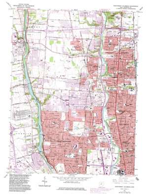
Northwest Columbus Topo Map Ohio
To zoom in, hover over the map of Northwest Columbus
USGS Topo Quad 40083a1 - 1:24,000 scale
| Topo Map Name: | Northwest Columbus |
| USGS Topo Quad ID: | 40083a1 |
| Print Size: | ca. 21 1/4" wide x 27" high |
| Southeast Coordinates: | 40° N latitude / 83° W longitude |
| Map Center Coordinates: | 40.0625° N latitude / 83.0625° W longitude |
| U.S. State: | OH |
| Filename: | o40083a1.jpg |
| Download Map JPG Image: | Northwest Columbus topo map 1:24,000 scale |
| Map Type: | Topographic |
| Topo Series: | 7.5´ |
| Map Scale: | 1:24,000 |
| Source of Map Images: | United States Geological Survey (USGS) |
| Alternate Map Versions: |
Northwest Columbus OH 1955, updated 1956 Download PDF Buy paper map Northwest Columbus OH 1955, updated 1963 Download PDF Buy paper map Northwest Columbus OH 1965, updated 1967 Download PDF Buy paper map Northwest Columbus OH 1965, updated 1971 Download PDF Buy paper map Northwest Columbus OH 1965, updated 1983 Download PDF Buy paper map Northwest Columbus OH 1995, updated 1999 Download PDF Buy paper map Northwest Columbus OH 1995, updated 2000 Download PDF Buy paper map Northwest Columbus OH 2010 Download PDF Buy paper map Northwest Columbus OH 2013 Download PDF Buy paper map Northwest Columbus OH 2016 Download PDF Buy paper map |
1:24,000 Topo Quads surrounding Northwest Columbus
> Back to 40083a1 at 1:100,000 scale
> Back to 40082a1 at 1:250,000 scale
> Back to U.S. Topo Maps home
Northwest Columbus topo map: Gazetteer
Northwest Columbus: Airports
Fawcett Center for Tomorrow Heliport elevation 220m 721′Ohio State University Airport elevation 274m 898′
Riverside Methodist Hospital Heliport elevation 232m 761′
Northwest Columbus: Bridges
Fishinger Bridge elevation 229m 751′Northwest Columbus: Canals
Roberts Millikin Ditch elevation 262m 859′Northwest Columbus: Crossings
Interchange 10 elevation 264m 866′Interchange 13 elevation 267m 875′
Interchange 20 elevation 276m 905′
Interchange 22 elevation 230m 754′
Interchange 23 elevation 272m 892′
Northwest Columbus: Dams
Brookside Country Club Lake Dam elevation 268m 879′Julian Griggs Dam elevation 229m 751′
Ohio State University Golf Course Lake Dam elevation 248m 813′
Northwest Columbus: Parks
Antrim Park elevation 228m 748′Beechwold Park elevation 225m 738′
Bill Moose Memorial elevation 235m 770′
Brevoort Park elevation 262m 859′
Broadmeadows Park elevation 235m 770′
Chadwick Arboretum elevation 228m 748′
Clinton Park elevation 222m 728′
Clintonville Park elevation 240m 787′
Como Park elevation 224m 734′
Delawanda Park elevation 225m 738′
Dublin High Street Historic District elevation 252m 826′
East Granville Park elevation 269m 882′
Fancyburg Park elevation 249m 816′
Hartford Park elevation 265m 869′
Hoover Park elevation 222m 728′
Indianola Park elevation 273m 895′
Iuka Ravine Historic District elevation 247m 810′
James J Thomas Park elevation 231m 757′
James Thomas Park elevation 237m 777′
Jesse Owens Plaza elevation 226m 741′
Lane Road Park elevation 268m 879′
Langston Park elevation 267m 875′
McCord Park elevation 280m 918′
Northam Road Park elevation 259m 849′
Northcrest Park elevation 271m 889′
Northmoor Park elevation 222m 728′
Northwest Park elevation 266m 872′
Ohio Stadium elevation 226m 741′
Old Beechwold Historic District elevation 245m 803′
Olde Sawmill Park elevation 276m 905′
Olentangy Park elevation 230m 754′
Olentangy River State Wildlife Access Area elevation 228m 748′
Perry Park elevation 259m 849′
Pingree Park elevation 274m 898′
Reed Road Park elevation 258m 846′
Riverside Green Park elevation 264m 866′
Sawmill State Wildlife Education Area elevation 274m 898′
Scioto Park elevation 249m 816′
Shelby Park elevation 267m 875′
Sycamore Hills Park elevation 254m 833′
Trautman Field elevation 226m 741′
Tuttle Field elevation 222m 728′
Tuttle Park elevation 220m 721′
Webster Park elevation 228m 748′
Whetstone Park elevation 231m 757′
Wilson Hill Park elevation 275m 902′
Woodbridge Green Park elevation 265m 869′
Worthington Hills Park elevation 232m 761′
Worthington Historic District elevation 268m 879′
Worthington Village Green elevation 268m 879′
Wyandote Park elevation 244m 800′
Wyandotte Park elevation 235m 770′
Northwest Columbus: Populated Places
Dublin elevation 253m 830′Eastcleft elevation 248m 813′
Highway (historical) elevation 251m 823′
Linworth elevation 253m 830′
Olentangy elevation 250m 820′
Riverlea elevation 240m 787′
Seagrave elevation 232m 761′
Worthington elevation 263m 862′
Northwest Columbus: Post Offices
Dublin Post Office elevation 252m 826′Linworth Post Office (historical) elevation 255m 836′
Olentangy Post Office (historical) elevation 249m 816′
Seagrave Post Office (historical) elevation 232m 761′
Worthington Post Office (historical) elevation 263m 862′
Northwest Columbus: Reservoirs
Brookside Country Club Lake elevation 268m 879′Griggs Reservoir elevation 229m 751′
Ohio State University Golf Course Lake elevation 248m 813′
Poste Lake elevation 274m 898′
Northwest Columbus: Streams
Ackerman Run elevation 223m 731′Adena Brook elevation 222m 728′
Bill Moose Run elevation 226m 741′
Glen Echo Run elevation 221m 725′
Hayden Run elevation 232m 761′
Indian Run elevation 234m 767′
North Fork Indian Run elevation 251m 823′
Rush Run elevation 228m 748′
Slate Run elevation 231m 757′
South Fork Indian Run elevation 244m 800′
Turkey Run elevation 222m 728′
Walhalla Creek elevation 221m 725′
Northwest Columbus: Swamps
Buckeye Swamp elevation 223m 731′Northwest Columbus: Valleys
Glen Echo Hollow elevation 223m 731′Walhalla Hollow elevation 237m 777′
Northwest Columbus digital topo map on disk
Buy this Northwest Columbus topo map showing relief, roads, GPS coordinates and other geographical features, as a high-resolution digital map file on DVD:


